River Landforms – Old Age Stage (Leaving Cert Geography): Revision Notes
River Landforms - Old Age Stage
Introduction to the old age stage
During the old age stage of a river's development, the character of the river changes significantly. The river has lost much of its energy by this point, which means deposition becomes the dominant process rather than erosion. The slow-moving water can no longer transport its sediment load effectively, causing material to be deposited along the riverbed and banks. Both the river channel and its valley have become much wider compared to earlier stages.
Understanding the Old Age Stage
This stage represents a fundamental shift in river behaviour. Unlike the vigorous erosional activity of youth and middle age stages, old age rivers are characterised by their reduced energy and capacity to transport material. This creates distinctive landforms through depositional processes.
Levees
Definition: Levee
A natural ridge of sediment that builds up along the banks of a river during its old age stage, creating a natural flood defence.
Levees develop through a gradual process that occurs over many years of repeated flooding. When the river experiences heavy rainfall and flooding, water spills over the riverbanks and flows across the surrounding floodplain. As this happens, the water loses speed and energy, causing it to deposit the sediment it has been carrying.
Formation Process: How Levees Build Up
The formation process works through these key stages:
- Heaviest material first: The largest and heaviest sediments are deposited immediately next to the river bank because the water loses velocity most quickly here
- Lighter material spreads out: Finer sediments are carried further across the floodplain before being deposited
- Ridge building: Over time, the repeated deposition of coarse material close to the riverbank creates raised ridges that grow higher with each flood
- Natural barriers: These ridges eventually become substantial enough to act as natural flood barriers
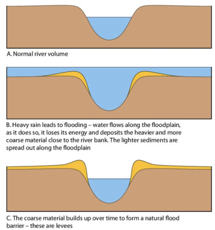
During dry periods, deposition continues but only occurs within the river channel itself. This raises the height of the riverbed. When combined with the growing levees, this can create a raised river channel where the river actually flows higher than the surrounding floodplain.
Critical Consequence: Back Swamps
When flooding occurs again, the floodplain may struggle to drain back into the river through the alluvium levee. This creates waterlogged areas called back swamps that develop on the floodplain behind the levees.
Natural levees can be observed along rivers like the River Moy in Ireland, demonstrating this process in action.
Oxbow lakes
Definition: Oxbow Lake
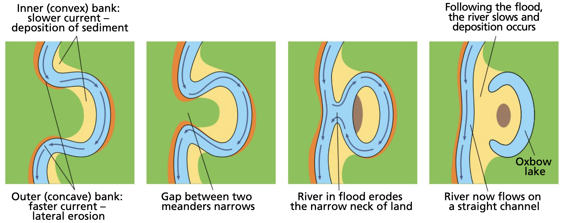
A curved, horseshoe-shaped body of water that develops when a river meander becomes cut off from the main river channel.
Oxbow lakes represent a fascinating continuation of the meander formation process that began in the river's middle course. While deposition is the main characteristic of the old age stage, lateral erosion still continues as meanders migrate downstream and become increasingly twisted with more pronounced bends.
Formation process
The development of an oxbow lake happens through a complex but predictable sequence of events:
Step-by-Step Formation: From Meander to Oxbow Lake
- Meander development: The river's meanders become more pronounced over time, creating increasingly curved bends
- Narrow neck formation: As the meander bends become more extreme, only a narrow strip of land separates the two outer banks of the meander loop
- Flood breakthrough: During times of flooding, the river's discharge and velocity increase dramatically, along with its erosive power
- Channel shortening: The fast-flowing floodwater cannot follow the long, curved path of the meander, so it cuts straight through the narrow neck of land between the outer bends
- Deposition and sealing: After the flood subsides, deposition occurs again. This sediment seals off both ends of the old meander loop, completely separating it from the main river channel
- Lake formation: The isolated curved channel becomes an oxbow lake
- Gradual disappearance: Since the oxbow lake is no longer connected to the river, it slowly dries up through evaporation. The dried-up remains are called a meander scar or mort lake
- Final stage: Repeated flooding from the main river eventually fills the mort lake with alluvium, causing it to disappear entirely
Examples of oxbow lakes can be found along the old age sections of most Irish rivers, including the Shannon, the Nore, and the Moy.
Deltas
Definition: Delta
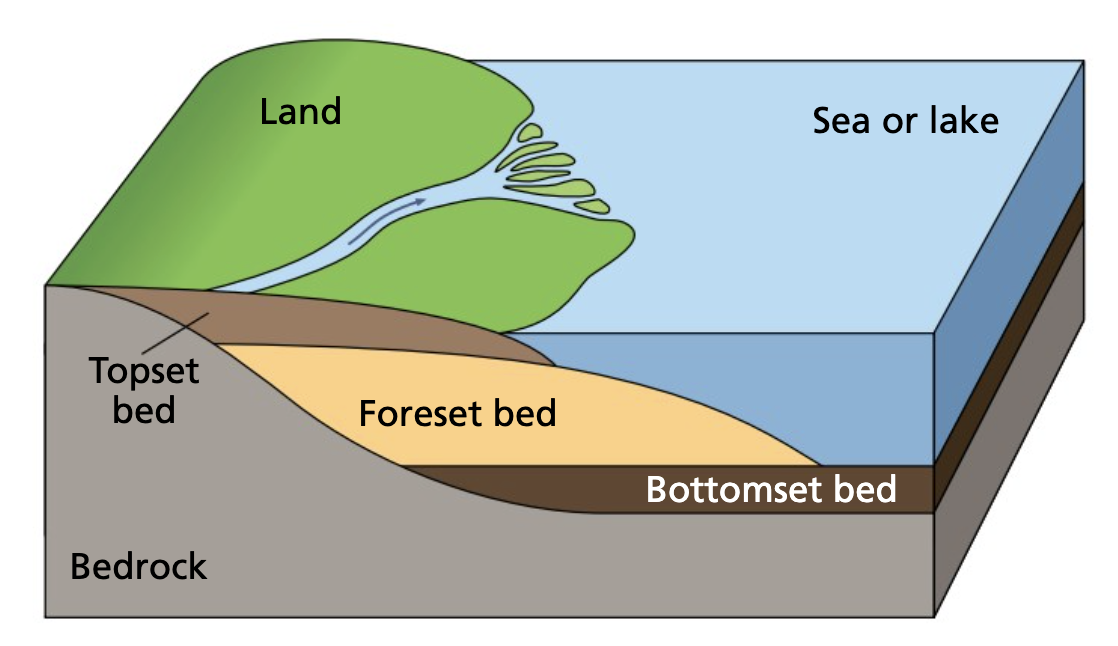
A flat, triangular area of alluvium that accumulates at the mouth of a river where it enters a lake or sea.
Deltas develop when rivers reach large bodies of water such as lakes or seas. As the river enters these calmer waters, it experiences a dramatic loss of velocity and energy, which means it can no longer transport its sediment load effectively.
Formation process
Delta Formation Process
Delta formation involves both erosional and depositional processes working together:
- Velocity reduction: When the river flows into a sea or lake, the water slows down significantly and begins depositing its sediment load along the mouth
- Channel clogging: The deposited material gradually clogs the mouth of the river with sediment
- Distributary formation: The river is forced to break into several smaller channels called distributaries to find ways around the accumulated sediment
- Continued growth: As more material is deposited, the delta advances further outwards from the original river mouth
Essential Conditions for Delta Formation
For a delta to successfully form, the river must carry large amounts of sediment and the rate of deposition must exceed the rate of erosion. Marine deltas typically only develop along calm seas (such as the Mediterranean Sea) because rough waters would wash away the deposited sediments.
Delta structure
Deltas have a distinctive three-layer structure that reflects different depositional environments:
- Bottomset beds: Horizontal layers of fine sediment that are carried furthest into the sea or lake ahead of the main delta
- Foreset beds: Thick layers of coarse material deposited closer to the river mouth that slope gently towards the sea
- Topset beds: Materials deposited closest to the river mouth, which eventually cause the mouth to become clogged with sediment
Types of deltas
There are three main types of marine delta, each with distinctive characteristics:
Arcuate deltas are the most common form of marine delta. They consist mainly of coarse alluvium and extend outwards in a curved, bow-like shape. These deltas are characterised by several distributaries that flow into the sea. The Nile Delta in Egypt is the best-known example of an arcuate delta.
Bird's foot deltas develop when deposition occurs specifically along the banks of the distributaries. Small levees form and grow outwards into the sea, creating a shape that resembles a bird's foot. The Mississippi Delta in the United States provides an excellent example of this type.
Estuarine deltas form when sediment builds up around the banks of river estuaries. The Shannon Delta in County Limerick serves as an example of estuarine delta formation in Ireland.
Examples in Ireland
Irish examples of delta formation can be observed at locations such as:
- Lough Tay in County Wicklow
- The Shannon Delta in County Limerick
Key Points to Remember:
- Deposition dominates the old age stage as rivers lose energy and can no longer transport their sediment load effectively
- Levees form natural flood defences through repeated cycles of flooding and sediment deposition, potentially creating raised river channels and back swamps
- Oxbow lakes develop when pronounced meanders are cut off from the main river channel during floods, eventually drying up to become meander scars
- Deltas require calm water conditions and large sediment loads to form successfully at river mouths
- Three delta types exist: arcuate (most common), bird's foot, and estuarine, each with distinctive shapes and formation processes