Active and Passive Plate Margins (Leaving Cert Geography): Revision Notes
Active and Passive Plate Margins
Understanding plate margins
Before exploring different types of plate margins, it's helpful to recall some fundamental concepts about plate tectonics. The Earth's surface consists of large sections called plates that float on the mantle beneath. When these plates interact by colliding or separating, they create significant geological activity including volcanic eruptions, earthquakes, and the folding and faulting of rock formations.
The interaction between plates is driven by convection currents in the Earth's mantle, which cause the plates to move at rates of just a few centimetres per year - about the same rate your fingernails grow!
These plate interactions also influence rock formation processes. Volcanic activity produces igneous rocks like granite and basalt, while the intense pressure from folding and subduction transforms existing rocks into metamorphic varieties.
Active plate margins
An active plate margin is the leading edge of a continental plate where it collides with an oceanic plate, creating intense tectonic activity including volcanoes, earthquakes, and mountain building.
Active plate margins develop when oceanic plates slide beneath continental plates in a process called subduction. This creates areas of intense geological activity with several important characteristics that distinguish them from more stable regions of the Earth's crust.
Geological processes at active margins
The subduction process triggers numerous geological activities that shape the landscape and create new rock formations:
- Volcanic activity occurs as the descending oceanic plate melts
- Earthquakes happen both in shallow areas near the surface and at deeper levels in the subduction zone
- Folding and faulting of rock layers creates mountain ranges
- Metamorphism transforms existing rocks under intense heat and pressure
The depth of earthquakes at active margins provides scientists with valuable information about the angle and extent of the subducting plate, helping them understand the three-dimensional structure of subduction zones.
Rock formation
Active margins are particularly important for creating new igneous and metamorphic rocks. The continent's newest igneous and metamorphic rock formations develop here due to the intense geological processes occurring.
Over geological time, weathering and erosion remove overlying sedimentary rock layers, exposing the underlying igneous and metamorphic rocks that formed during earlier periods of tectonic activity. This process reveals the complex geological history of these dynamic regions.
Mineral formation
The metamorphic processes at active margins create economically valuable mineral deposits, including:
- Diamonds
- Iron ore
- Copper
These valuable resources form under the extreme conditions of temperature and pressure found in active margin environments.
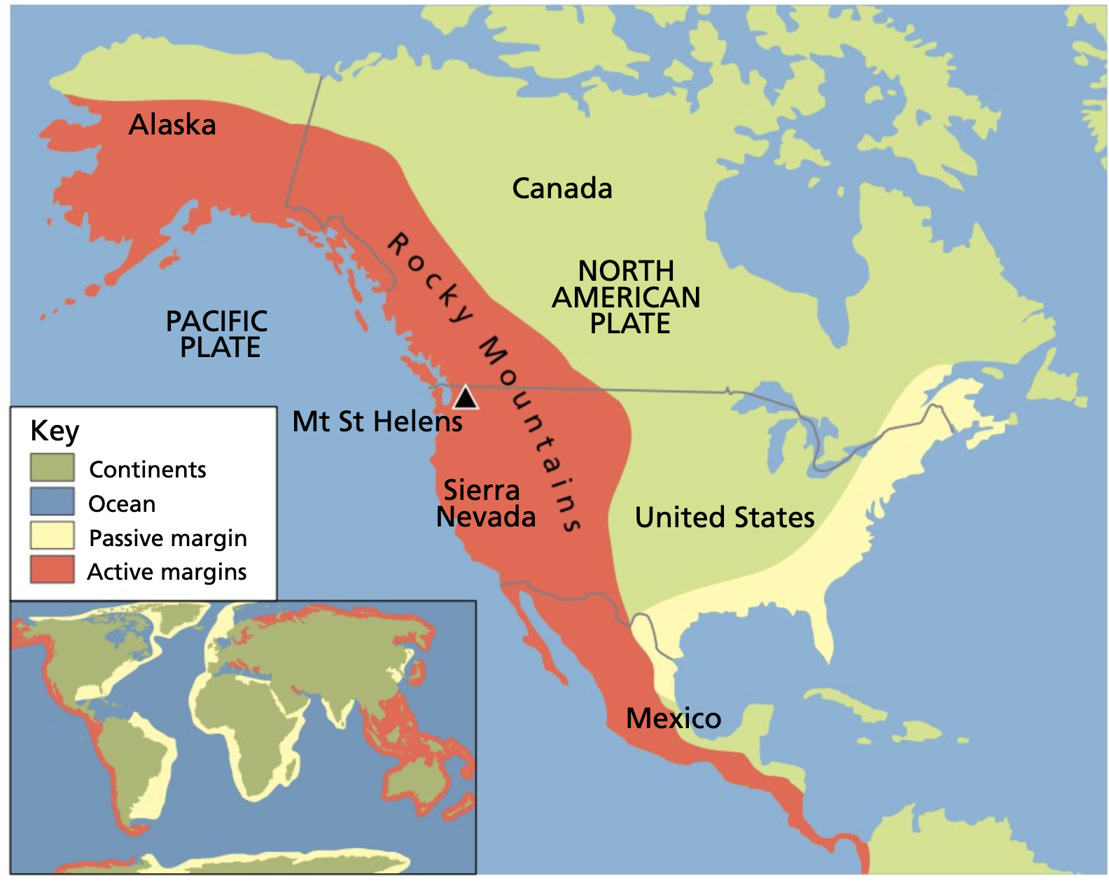
Case study: North American west coast
Case Study: Pacific Plate Subduction
The Pacific Plate provides an excellent example of an active margin as it subducts beneath the eastern section of the North American Plate. This collision zone demonstrates all the classic features of active margins:
- Seismic Activity: The region experiences regular earthquakes, with both shallow crustal earthquakes (0-70 km deep) and deeper subduction zone earthquakes (70-700 km deep) occurring frequently
- Volcanic Activity: The Cascade Range, including Mount St. Helens and Mount Rainier, formed from this subduction process
- Mountain Building: The Coast Ranges and other mountain systems developed from the compressive forces
Passive plate margins (trailing margins)
A trailing plate margin is the inactive edge of a continent where tectonic activity is absent, and weathering and erosion are the primary landscape-shaping processes.
Trailing plate margins represent the opposite condition to active margins. These areas experience no significant seismic, volcanic, or folding activity, making them tectonically stable regions where different geological processes dominate.
Dominant processes
Since tectonic forces are absent, the main geological processes shaping these landscapes are:
- Weathering breaks down existing rock formations through chemical and physical processes
- Erosion removes weathered material and transports it elsewhere
- Deposition creates new sedimentary layers in low-lying areas
The absence of tectonic activity at passive margins allows these surface processes to operate over very long periods without interruption, leading to the formation of extensive sedimentary sequences.
These processes work together over long periods to create thick sequences of sedimentary rocks, particularly limestone and sandstone.
North American trailing margin regions
The trailing margin of North America can be divided into two distinct areas, each with unique geological characteristics:
1. The Canadian shield
The Canadian Shield is a vast area covering over 8 million km² of low-lying crystalline rock across northeastern North America.
The Canadian Shield represents some of Earth's oldest exposed rock formations. Originally consisting of igneous rock, this region underwent intense metamorphism through folding and faulting processes nearly 4 billion years ago.
During the last ice age, glacial activity eroded away thin layers of overlying sedimentary rock, exposing the ancient metamorphic rock beneath. The intense metamorphic processes that shaped this region created valuable mineral deposits, particularly:
- Copper
- Gold
- Iron ore
The Canadian Shield's ancient rocks provide scientists with valuable insights into the Earth's early history, including evidence of some of the planet's earliest life forms and atmospheric conditions.
2. Coastal plains
Coastal plains are low-lying areas along North America's southeastern coast composed primarily of sandstone formations.
The coastal plains formed through a different process than the Canadian Shield. Mountain ranges in the continental interior underwent erosion, and the resulting sediments were transported and deposited in shallow coastal seas along the eastern margin.
Over geological time, these sediments became compressed and underwent lithification, transforming into sandstone. Tectonic uplift later raised these formations above sea level, whilst limestone deposits formed in warmer offshore waters.
The region also developed significant oil and gas reserves as organic sediments partially decomposed in the shallow marine environments, creating valuable hydrocarbon deposits that are now economically important resources.
Formation Process: Coastal Plains Development
Step 1: Erosion Phase - Mountain ranges in the interior (such as the Appalachians) were weathered and eroded over millions of years
Step 2: Transportation - Rivers carried the eroded sediments eastward towards the Atlantic coast
Step 3: Deposition - Sediments were deposited in shallow coastal seas, building up thick layers over time
Step 4: Lithification - Pressure from overlying sediments compressed the deposits into solid sandstone
Step 5: Uplift - Gradual tectonic uplift raised the sea floor above sea level, creating the modern coastal plains
Summary
Key Points to Remember:
- Active plate margins occur where oceanic plates subduct beneath continental plates, creating volcanoes, earthquakes, and new igneous/metamorphic rocks
- Passive (trailing) plate margins lack tectonic activity and are shaped primarily by weathering, erosion, and sediment deposition
- The Canadian Shield contains some of Earth's oldest metamorphic rocks and valuable mineral deposits formed 4 billion years ago
- Coastal plains developed from sediments eroded from interior mountains and deposited in shallow seas, later forming sandstone and oil/gas reserves
- Active margins create new rock through metamorphism and igneous processes, while passive margins accumulate sedimentary rock layers through deposition