Karst Landscapes - Irish Karst (Leaving Cert Geography): Revision Notes
Karst Landscapes - Irish Karst
What is karst?
Karst refers to an area of exposed limestone that has been shaped by the chemical weathering process of carbonation. The term 'karst' comes from the name of a limestone region in Slovenia along the eastern coast of the Adriatic Sea.
Karst landscapes develop because limestone is a permeable rock, meaning water can drain through it easily. The unique properties of limestone make it particularly susceptible to chemical weathering processes that create distinctive landscape features over time.
Limestone is permeable for three main reasons:
- It is porous - limestone contains small holes that can hold water
- It is pervious - it has joints that allow water to pass through it
- It dissolves in carbonic acid - causing it to be chemically weathered
Understanding these characteristics is essential for explaining why karst landscapes form in limestone regions and not in other rock types.
How karst landscapes form
The formation of karst landscapes happens through a process called carbonation. This chemical weathering process is fundamental to understanding how these unique landscapes develop over thousands of years.
Worked Example: The Carbonation Process
Step 1: Acid formation Water in the atmosphere mixes with carbon dioxide, forming weak carbonic acid
Step 2: Chemical reaction When this carbonic acid falls on limestone as rain, it reacts with the calcium carbonate in the rock
Step 3: Dissolution This reaction turns the limestone into calcium bicarbonate, which is soluble and washes away in solution
The chemical equations that show this process are:
- Formation of carbonic acid:
- Weathering of limestone:
This process causes large sections of limestone to dissolve, which enlarges joints on the surface and carves out underground drainage systems. This leads to the creation of unique karst features both on the surface and underground.
Irish karst landscapes
Ireland's landscapes provide excellent examples of karst features because limestone is the most common rock type in the country. The geological composition of Ireland makes it particularly well-suited for studying karst processes and formations.
The two main karst regions in Ireland are:
- The Burren in County Clare
- The Marble Arch region in County Fermanagh
Glacio-karst describes limestone landscapes that have been affected by glaciation. This term is particularly relevant to understanding Irish karst features.
During the last ice age, large glaciers moved across the Burren, eroding away the topsoil and exposing the limestone rock underneath. This is why the Burren is referred to as 'glacio-karst' - it shows the combined effects of both glacial erosion and chemical weathering.
Surface features
The main surface features found in Irish karst landscapes include limestone pavement, swallow holes, and dry valleys. Each of these features represents different aspects of how water interacts with limestone over time.
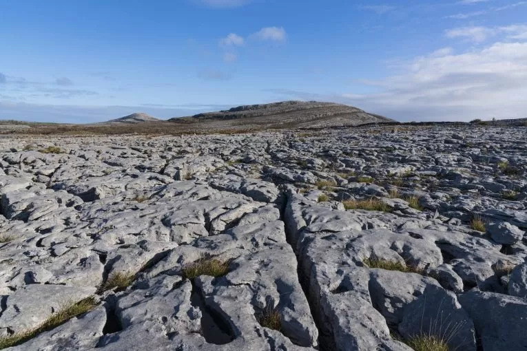
Limestone pavement
Limestone pavement consists of flat, exposed blocks of limestone that are separated by deep, intersecting joints. The Burren in County Clare provides excellent examples of this feature, making it one of the most studied karst landscapes in Europe.
Worked Example: Limestone Pavement Formation
Step 1: Glacial exposure Once glaciers stripped away the overlying soil and rock, the underlying limestone was exposed to the environment
Step 2: Carbonation begins As limestone is naturally jointed and cracked, carbonic acid from rainwater is very effective at dissolving it
Step 3: Percolation occurs Carbonic acid flows through the limestone's cracks and joints, dissolving the rock and widening the gaps
Step 4: Grikes develop The widening and deepening of joints forms intersecting lines called grikes
Step 5: Clints form As grikes deepen, the remaining limestone is divided into sections called clints
Key Definitions:
- Percolation is the movement of water through pores and holes in rock
- Grikes are intersecting lines formed in limestone exposed to carbonation
- Clints are blocks of limestone divided by grikes
Additional features develop on limestone pavement through continued weathering processes:
- Karrens - small hollows that form on clints through carbonation
- Fluting - channels carved out along clints as water flows from karrens into grikes
Swallow holes and dry valleys
A swallow hole is a narrow, funnel-shaped hole where a river flows and disappears underground.
Swallow holes are common features in all karst regions and are also known as sluggas. Many examples, such as Poll na gColm, can be found in the Burren region. They form through a combination of erosion, carbonation, and solution processes.
Worked Example: Swallow Hole Formation
Step 1: River meets limestone A swallow hole marks the point where a river disappears underground in a limestone region
Step 2: Underground channel forms Once the river flows into the swallow hole, it dissolves a channel underneath the surface
Step 3: Grikes provide access When water lands on karst surfaces, it quickly disappears underground through grikes
Step 4: Vertical passage develops As grikes widen and deepen through carbonation, they join with other grikes, creating a large vertical passage
Step 5: Roof collapse The river flows into this passage and disappears underground. Eventually, after more limestone dissolves, the roof of the passage weakens and collapses, opening up the swallow hole
Swallow holes commonly form where limestone borders an impermeable rock such as shale. Water flows across the impermeable rock before seeping through the limestone and disappearing.
When rivers disappear through swallow holes, they leave behind dry sections of river valley. These dry valleys can extend for considerable distances across karst landscapes, creating distinctive linear features that may only carry water during certain seasons.
The point of resurgence is where a river reappears on the surface after flowing underground through a swallow hole.
During winter in Ireland, many dry valleys are temporarily filled with water as the water table rises above the height of swallow holes. The water usually disappears again during summer as underground passages drain it away, demonstrating the seasonal variability of karst drainage systems.
Key Points to Remember:
-
Karst landscapes form through carbonation - carbonic acid dissolves limestone, creating distinctive surface and underground features
-
Irish karst is glacio-karst - glacial erosion exposed limestone in areas like the Burren, allowing chemical weathering to create karst features
-
Limestone pavement consists of clints and grikes - flat limestone blocks separated by deep intersecting joints formed through percolation and carbonation
-
Swallow holes mark river disappearance points - rivers flow underground through these funnel-shaped holes, often leaving dry valleys behind
-
Seasonal changes affect features - dry valleys may fill with water in winter when water tables rise above swallow hole levels