How Remote Sensing Works (Grade 10 NSC Matric Geography): Revision Notes
How Remote Sensing Works
What is remote sensing?
Remote sensing is a method of gathering information about the Earth's surface without making direct physical contact with it. Think of it as studying something from far away, like taking a photograph of a landscape from an aeroplane.
This technology works by using instruments mounted on satellites, aircraft, ocean buoys, and ships to collect data about land surfaces, water bodies, and the sea floor. The key advantage is that we can study areas that might be dangerous, remote, or simply too large to examine on foot.
Remote sensing allows geographers and scientists to monitor changes across vast areas over time, making it an essential tool for understanding our planet. This capability is particularly valuable for tracking environmental changes, urban development, and natural disasters on a global scale.
Types of remote sensing data
Remote sensing works by detecting and recording different types of electromagnetic radiation that come from the Earth's surface. Everything on Earth naturally gives off or reflects energy at different wavelengths and frequencies.
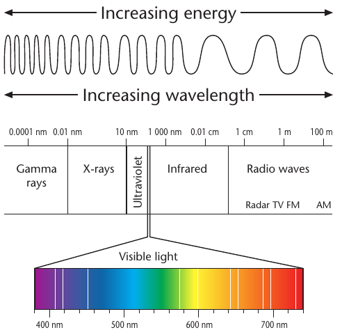
The electromagnetic spectrum includes many different types of energy waves, from very short gamma rays to very long radio waves. Each type of wave carries different information about what it has bounced off or been emitted from.
Some important parts of the electromagnetic spectrum used in remote sensing include:
- Visible light - what our eyes can see (like colours in a rainbow)
- Infrared radiation - heat energy that we can feel but not see
- Radio waves - longer waves used by radar systems
Different sensors can detect specific parts of this spectrum, allowing scientists to gather various types of information about the same area. For example, visible light sensors show us what an area looks like, while infrared sensors can detect temperature differences.

This global temperature map shows how remote sensing data can reveal patterns that would be impossible to see with the naked eye, such as ocean temperature variations across the entire planet. The ability to see these invisible patterns is what makes remote sensing so powerful for scientific research.
Active and passive remote sensing
There are two main ways that remote sensing systems collect information: active and passive methods.
Passive remote sensing
Passive remote sensing systems work like our eyes or a camera - they simply record the natural energy that is reflected or emitted from the Earth's surface. These systems don't send out any signals of their own.
Examples of passive remote sensing include:
- Cameras that record visible light reflected from the ground
- Infrared sensors that detect heat energy naturally given off by objects
- Satellite imagery that captures sunlight bouncing off the Earth's surface
Active remote sensing
Active remote sensing systems work more like a torch in a dark room - they send out their own energy signal towards the Earth and then record what comes back. This allows them to work even in darkness or through clouds.
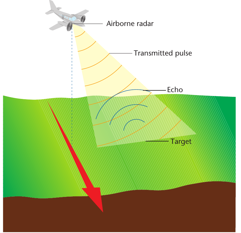
Example: How Radar Works
The most common example is radar, which stands for Radio Detection And Ranging. Here's how it works:
Step 1: Radar systems send out radio wave pulses toward the ground
Step 2: These pulses bounce off objects and return to the sensor
Step 3: The system measures how long the waves take to return
Step 4: The time and strength of returned signals reveal information about object shape, distance, and properties
Radar is particularly useful because radio waves can penetrate through clouds, rain, and even vegetation, allowing scientists to map the ground surface even in bad weather conditions. This makes active remote sensing invaluable for all-weather monitoring.
Satellite systems and coverage
Different types of satellites provide different advantages depending on their orbit around Earth.
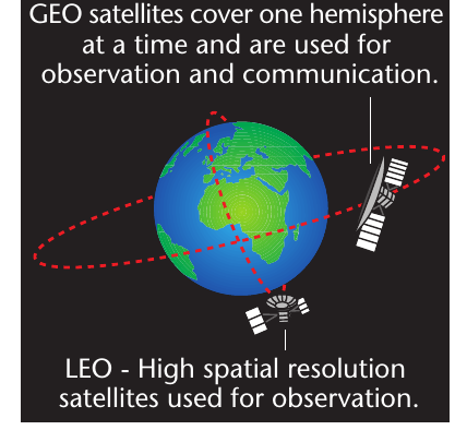
GEO satellites (Geostationary Earth Orbit)
- Orbit at very high altitudes (about 36,000 km above Earth)
- Stay fixed above the same point on Earth's surface
- Can observe one entire hemisphere continuously
- Used mainly for weather monitoring and communications
- Provide less detailed images due to their great distance from Earth
LEO satellites (Low Earth Orbit)
- Orbit much closer to Earth (typically 200-2,000 km altitude)
- Move around the Earth, covering different areas over time
- Provide high-resolution, detailed images
- Used for detailed Earth observation and mapping
- Can capture very small features on the ground
The choice between GEO and LEO satellites depends on whether you need continuous coverage of one area (GEO) or very detailed images of different areas over time (LEO). Each type serves specific monitoring and research purposes.
Applications of remote sensing
Remote sensing technology has revolutionised how we study and monitor our planet. Different types of sensors serve specific purposes across many fields.
| Type of sensor | Uses |
|---|---|
| Visible-light camera | • High-resolution images for tracking development and surface changes • Creating stereoscopic images and topographical maps |
| Infrared sensor | • Measuring heat for military target detection • Temperature sensing of water and land surfaces • Locating geothermal features and geological structures • Finding damaged water pipes |
| RADAR sensor | • Detecting range, speed, altitude and direction of objects • Weather observations (clouds, precipitation, storms, wind speed) • Oceanography and sea floor mapping • Tracking deforestation over time • Finding archaeological sites, even in rainforests • Working through clouds and in all weather conditions |
| LIDAR sensor | • Measuring atmospheric chemicals like greenhouse gases • Very accurate height measurements of ground features • Vegetation monitoring and forest studies |
| Earth-monitoring satellites (LANDSAT, SPOT, IKONOS) | • Land cover and land use monitoring • Forestry and farming applications • Estimating crop production and soil moisture • Mining exploration and geological mapping • Weather and climate monitoring • Producing detailed topographical maps |
Real-world applications
Remote sensing helps professionals in many different fields:
- Weather forecasters use satellite data to track storms and predict weather patterns
- Farmers monitor crop health and estimate harvest yields
- Miners locate potential mineral deposits and plan extraction sites
- Archaeologists discover ancient sites hidden beneath vegetation or sand
- Environmental scientists track deforestation, pollution, and climate change
- Urban planners monitor city growth and development patterns
- Emergency services assess damage from natural disasters
The ability to study dangerous or remote areas safely, combined with continuous monitoring capabilities, makes remote sensing an invaluable tool for understanding and managing our planet's resources and environment.
Key Points to Remember:
- Remote sensing collects information about Earth's surface from a distance without direct contact
- Electromagnetic spectrum provides different types of data - visible light shows appearance, infrared shows heat, radio waves penetrate clouds
- Passive sensors record natural energy reflected or emitted from Earth's surface (like cameras)
- Active sensors send out their own signals and record what bounces back (like radar)
- Different satellite orbits serve different purposes - GEO for continuous coverage, LEO for detailed images
- Multiple applications make remote sensing essential for weather forecasting, agriculture, mining, archaeology, and environmental monitoring