The Development of a GIS (Grade 10 NSC Matric Geography): Revision Notes
The Development of a GIS
What is a Geographic Information System?
A Geographic Information System (GIS) is a powerful digital tool that combines computer technology with geographical data. Think of it as a super-smart map that can do much more than just show you where things are located.
A GIS is an interconnected system made up of:
- Computer hardware and software
- Geographic data about Earth's features and processes
- Tools that allow users to capture, store, update, manipulate, analyse and display geographic information
How does GIS work in practice?
Practical Example: Finding the Best School
Imagine you want to find the best school in your area. A traditional paper map would only show you where schools are located. But with GIS, you could:
- See how many learners attend each school
- Find out what sports facilities each school offers
- Identify which school is closest to parks and recreational facilities
- Calculate travel distances and times to each school
- Compare all this information to make the best choice
This is possible because GIS can layer different types of information on top of a basic map, creating a comprehensive picture that helps with decision-making.
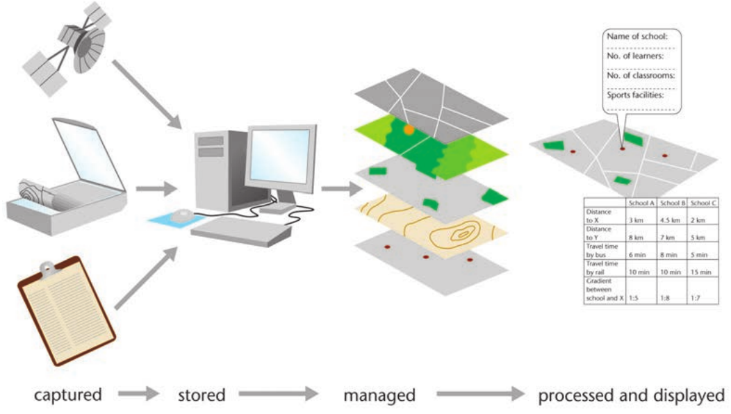
The diagram above shows how GIS processes work from data collection through to final analysis and display.
Why was GIS developed?
Limitations of traditional maps
Traditional topographic maps have several important limitations that led to the need for more advanced systems:
- They can only show a limited amount of information at once
- They are static, meaning they don't change to show new patterns or updated information
- Users cannot easily combine different types of data on the same map
- They don't allow for complex analysis of spatial relationships and patterns
Advantages of computer technology
Modern computers have revolutionised how we handle geographic data by enabling:
- Sophisticated data handling: Computers can manage complex sets of geographic data much more effectively than manual methods
- Advanced calculations: Mathematical analysis of spatial patterns and relationships
- Data manipulation: The ability to combine, update and modify geographic information quickly
- Digital processing: Converting information into formats that can be easily updated and shared
The role of satellite technology
Two key technological developments made GIS possible and transformed how we collect and process geographic information.
Remote sensing - This refers to collecting data about objects from a distance. Examples include:
- Satellite images
- Radar images
- Aerial photographs
Satellite tracking technology has enabled:
- Global positioning devices that can record precise geographic coordinates
- Regular updates of satellite images showing changing conditions on Earth's surface
- The ability to track trends over time, such as rising sea levels affecting coastal areas
The GIS process
GIS follows a systematic four-stage process for handling geographic information:
Understanding this systematic process is essential because it shows how raw geographic data is transformed into useful information for decision-making.
1. Captured
Geographic data is collected from various sources including:
- Satellite communications and imagery
- Field surveys using laptops and mobile devices
- Paper documents and forms
- GPS devices
2. Stored
All collected data is stored digitally in computer databases where it can be:
- Organised by categories
- Linked to specific geographic locations
- Kept secure and accessible
3. Managed
The stored data is organised and maintained through:
- Regular updates as new information becomes available
- Quality checks to ensure accuracy
- Organisation into different data layers
4. Processed and displayed
Finally, the data is:
- Analysed using mathematical models
- Combined into visual maps with multiple layers
- Presented in formats that help users make decisions
- Made available through interactive digital interfaces
Key benefits of GIS
GIS technology allows geographers and researchers to:
- Discover new relationships between different spatial features
- Analyse patterns and trends in geographic data
- Predict future changes based on current patterns
- Make informed decisions about spatial planning and resource management
- Update information quickly as conditions change
This makes GIS an invaluable tool for professions ranging from urban planning and environmental management to business location analysis and emergency response planning.
Key Points to Remember:
- GIS combines computer technology with geographic data to create powerful analysis tools that go far beyond traditional maps
- The main advantage over traditional maps is that GIS is dynamic, interactive, and can combine multiple data layers for complex analysis
- Satellite technology and remote sensing were crucial developments that made modern GIS possible
- The four-stage GIS process follows the sequence: captured → stored → managed → processed and displayed
- GIS enables spatial analysis that helps identify patterns, predict trends, and support decision-making in many professional fields