Movement of Continents (Grade 10 NSC Matric Geography): Revision Notes
Movement of Continents
The movement of continents is one of the most fascinating discoveries in earth science. This concept explains how the landmasses we see today were once joined together as a single supercontinent that slowly broke apart over millions of years.
The development of continental drift theory
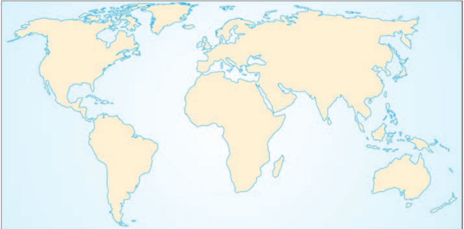
For many years, people noticed that the world's continents seemed to fit together like pieces of a jigsaw puzzle. When you look at a world map, you can see how South America appears to fit closely with Africa, whilst North America fits with Europe. Antarctica, Australia, India and Madagascar also seem to fit next to the southern and eastern parts of Africa.
In 1915, a German geologist named Alfred Wegener developed a theory to explain this continental puzzle. He suggested that the continents changed positions by 'drifting' on top of Earth's mantle. This movement, he proposed, took place over millions of years. Wegener could not provide enough clear evidence to prove his theory of continental drift at the time, so his ideas remained largely unsupported until the 1960s, when new scientific evidence was discovered.
Continental drift is a theory that suggests continents change their position over time by slowly moving on top of the mantle.
The breakup sequence of continents
According to continental drift theory, all continents were originally formed from one large landmass that slowly broke apart to create the continents we see today.
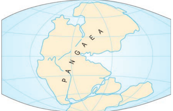
Pangaea - the original supercontinent
Around 180 million years ago, the world consisted of one massive landmass called Pangaea. This supercontinent contained all of today's continents joined together as a single piece of land.
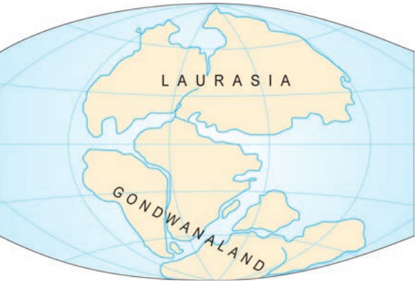
The formation of Laurasia and Gondwanaland
About 175 million years ago, Pangaea began to break apart into two large supercontinents:
The Great Division: Pangaea Splits in Two
- Laurasia - the northern landmass (containing what would become North America, Europe, and Asia)
- Gondwanaland - the southern landmass (containing what would become South America, Africa, Australia, Antarctica, and India)
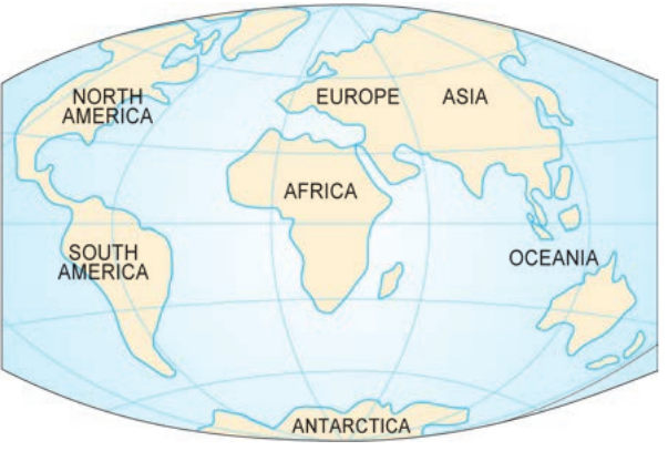
Final separation into modern continents
Between 150 and 65 million years ago, Gondwanaland and Laurasia continued to separate, slowly forming the continents we know today. This gradual process eventually created the seven continents: North America, South America, Europe, Asia, Africa, Australia (Oceania), and Antarctica.
Key terms:
- Pangaea, Gondwanaland, Laurasia - names of ancient landmasses that gave rise to the present continents
Evidence supporting continental movement
Scientific developments in the 1960s began to provide strong evidence that supported Wegener's theory of continental drift. This evidence comes from several different sources that all point to the same conclusion: continents have moved over time.
Evidence means information that proves an idea or theory to be correct.
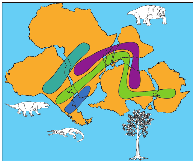
Fossil evidence
Scientists have discovered very similar fossils of animals and plants on continents that are now separated by wide oceans. These identical fossils suggest that these landmasses were once connected, allowing the same species to live across what is now different continents.
Fossil Evidence in Action
When paleontologists found identical plant and animal fossils on South America and Africa - continents now separated by the Atlantic Ocean - this provided strong evidence that these landmasses were once joined together, allowing the same species to inhabit both areas.
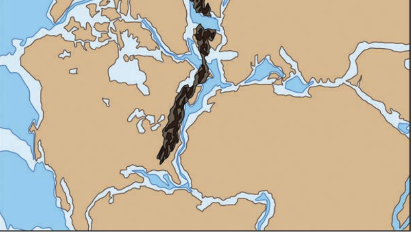
Rock formation evidence
Many rock formations in South America and West Africa have the same age and composition. Mountain ranges in North America have identical rocks and structure to mountains in Britain and Scandinavia. This matching geology indicates these areas were once joined together.
Matching Mountain Ranges
The Appalachian Mountains in North America contain rocks with identical composition and age to mountain ranges in Britain and Scandinavia. This remarkable similarity suggests these mountain chains were once part of the same geological formation before the continents drifted apart.
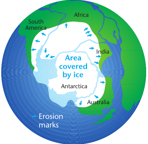
Ice age evidence
There is clear evidence of ice erosion and ice deposition over much of the southern continents. This could only have happened if these landmasses were positioned close to the South Pole during an ancient ice age. The ice-erosion marks on these continents match up when the continents are positioned together.
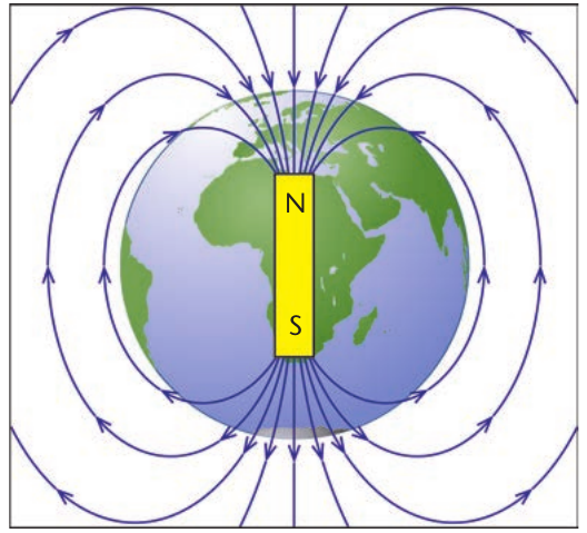
Magnetic field evidence
Earth's magnetic field acts like a giant magnet with north and south magnetic poles. When magma cools to form igneous rocks, iron minerals in the magma record the position of Earth's magnetic field at that time. Scientists expected that minerals in rocks of the same age would all point in the same direction, but they discovered they point in different directions. This suggests that the position of the rocks has changed since they were formed.
Magnetic Field Records Tell a Story
When scientists studied iron-rich rocks of the same age from different continents, they found that the magnetic minerals pointed in completely different directions. This was puzzling until they realized that the rocks hadn't moved - the continents themselves had drifted to new positions since the rocks formed, carrying their "frozen" magnetic records with them.
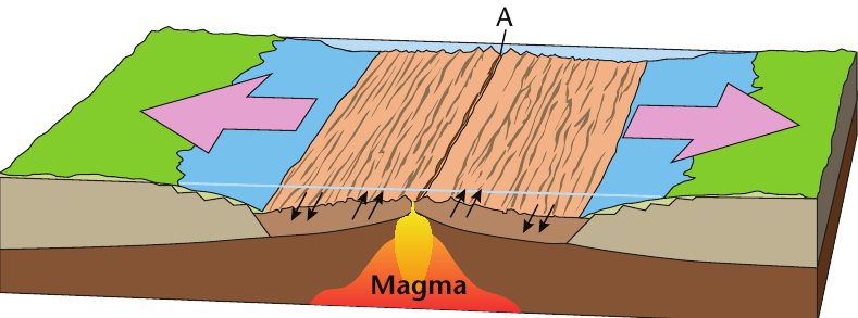
Seafloor spreading evidence
Scientists have identified chains of small volcanoes under the oceans where new ocean crust is being produced. This causes the ocean floors to spread outwards from underwater mountain ridges. The rocks close to these ridges are much younger than rocks further away, which supports the idea that new seafloor is constantly being created and pushing the continents apart.
The Ocean Floor Factory
At mid-ocean ridges, new seafloor is constantly being created as magma rises from the mantle. The youngest rocks are found right at the ridge, while progressively older rocks are found further away. This pattern shows that the ocean floor is spreading outward like a conveyor belt, gradually pushing continents apart.
Why the theory was initially rejected
When Wegener first proposed continental drift theory, it faced significant resistance from the scientific community. Understanding why helps us appreciate how scientific theories develop and gain acceptance over time.
Why Scientists Initially Rejected Continental Drift:
- He could not explain what force was powerful enough to move entire continents
- The technology to gather supporting evidence did not exist yet
- Many scientists found it difficult to imagine continents moving
- There was limited evidence available at the time
It was only in the 1960s, when new technology allowed scientists to study the ocean floor and gather magnetic evidence, that continental drift theory gained widespread acceptance and developed into modern plate tectonics theory.
Key Points to Remember:
- Continental drift theory was proposed by Alfred Wegener in 1915 to explain how continents have moved over time
- Pangaea was the original supercontinent that existed 180 million years ago and gradually broke apart
- The breakup sequence was: Pangaea → Laurasia and Gondwanaland → modern continents
- Five types of evidence support continental movement: fossil evidence, rock formations, ice age evidence, magnetic field evidence, and seafloor spreading
- The theory was initially rejected but became accepted in the 1960s when new evidence was discovered