Case Study of a Flood in South Africa (Grade 10 NSC Matric Geography): Revision Notes
Case Study of a Flood in South Africa
The 2011 South African floods
Background and causes
In January 2011, South Africa experienced devastating floods that highlighted the country's vulnerability to extreme weather events. These floods were primarily caused by the La Niña weather phenomenon, which brought weeks of heavy rainfall across the region. La Niña is a climate pattern that typically results in increased precipitation in certain parts of the world, including southern Africa.
The South African government later acknowledged that the country could have been better prepared for this natural disaster. This admission highlights the importance of disaster preparedness and early warning systems in vulnerable regions.
The floods were part of a broader pattern of extreme weather that also affected other countries, with similar La Niña-related flooding occurring in Brazil and Australia during the same period, demonstrating the global reach of this climate phenomenon.
Scale and impact of the disaster
The 2011 floods were truly catastrophic in their scope and impact. The disaster affected a massive area, with floods declared in 33 municipalities across eight of South Africa's nine provinces. This demonstrates how widespread the flooding was and how it touched nearly every part of the country.
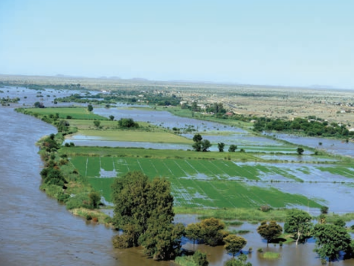
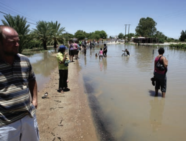
The human cost was severe, with more than 120 people losing their lives to the floods. Beyond the tragic loss of life, approximately 13,000 homes were completely destroyed, leaving thousands of families without shelter. An additional 20,000 people required emergency relief assistance, showing the scale of the humanitarian crisis that unfolded.
Economic and agricultural losses
The economic impact of the 2011 floods was enormous, with damage estimates reaching into the billions. The agricultural sector was particularly hard hit, with organised agriculture reporting that farmers alone suffered losses of approximately two billion rand. This figure only covered crop damage and did not include livestock losses or damage to farm infrastructure.
One woman interviewed during the floods captured the desperation faced by many farmers: "You can't even speak of crops in the fields. Everything is under water. I don't know what I am going to eat." This quote illustrates how the floods didn't just cause economic losses but threatened people's basic survival and food security.
were especially vulnerable to the disaster's effects. Many lost their entire harvest and had no insurance or resources to help them recover quickly from the devastation.
Infrastructure and water management challenges
The floods revealed serious concerns about South Africa's water infrastructure and flood management systems. The Gariep Dam, the country's largest dam, reached dangerous levels during the crisis. Officials warned that the dam was already 112% full and was projected to reach 152% of its capacity, creating fears about potential dam failures.
Maphaka Tau, a senior disaster official, warned that rising dam levels could lead to the opening of additional dam sluice gates, which would worsen flooding downstream. This situation highlighted how flood management becomes more complex when water storage infrastructure reaches capacity.
Investigating floods through fieldwork
Understanding floods and their impacts requires systematic investigation using geographical fieldwork methods. The newspaper report about the 2011 South African floods serves as an excellent example of how information about disasters is collected, processed, and presented.
Collecting information
When investigating floods, researchers and journalists use several methods to gather comprehensive information:
Research activities involve finding out what physical processes caused the flooding. In the case of the 2011 floods, researchers identified La Niña as the primary atmospheric cause.
Interview techniques allow investigators to gather firsthand accounts from people directly affected by the floods. These interviews provide valuable qualitative information about how the disaster impacted individuals and communities.
Statistical data collection involves gathering measurable information about flood impacts, such as rainfall amounts, water levels, economic losses, and casualty figures.
Photographic evidence serves as visual proof of flood impacts and helps document the scale and severity of the disaster.
Processing information
Once information has been collected, it needs to be organised and analysed. This processing stage might involve creating graphs to show rainfall patterns, making tables to compare damage across different regions, or arranging information under clear headings for easier understanding.
The distinction between two types of information is crucial during processing:
Quantitative information deals with measurements, numbers, and statistics - things that can be counted or measured precisely. Examples include the number of people affected, rainfall amounts in millimetres, and economic losses in currency.
Qualitative information focuses on descriptions, feelings, opinions, and experiences that cannot easily be measured. This includes personal testimonies from flood victims, descriptions of how communities responded, and assessments of government preparedness.
Presenting information
The final stage involves presenting findings in a format that others can understand and learn from. In the case of flood investigations, this often takes the form of newspaper articles, government reports, or academic studies.
Effective presentation requires the writer to analyse evidence collected during fieldwork and use this evidence to explore ideas and reach conclusions about the situation. The newspaper report about the 2011 floods demonstrates this approach by combining statistical information, interview quotes, photographs, and research findings to create a comprehensive picture of the disaster.
Key flood management concepts
Emergency relief
Emergency relief refers to immediate assistance provided to people affected by disasters. During the 2011 floods, 20,000 people needed emergency relief, which typically includes temporary shelter, food, clean water, and medical care.
Providing effective emergency relief presents many challenges, including reaching isolated communities, coordinating between different agencies, and ensuring supplies reach those most in need. These logistical challenges become even more complex during widespread disasters like the 2011 floods.
Dam management during floods
When dams reach capacity during flooding, water managers face difficult decisions. If a dam becomes more than 100% full, as the Gariep Dam did in 2011, managers may need to release water through sluice gates to prevent dam failure.
However, releasing water downstream can worsen flooding in communities below the dam, creating a challenging balance between protecting dam infrastructure and minimising flood damage. This dilemma highlights the need for integrated flood management planning that considers both upstream storage and downstream impacts.
Key Points to Remember:
-
La Niña weather patterns can cause devastating floods across southern Africa, as demonstrated by the 2011 South African floods that killed over 120 people and affected eight provinces
-
Flood impacts are multi-dimensional, affecting human life, property, agriculture, and infrastructure - the 2011 floods caused billions of rand in damage and destroyed 13,000 homes
-
Effective flood investigation requires three key stages: collecting information (through research, interviews, statistics, and photographs), processing data (organising and analysing findings), and presenting results (creating reports that analyse evidence and draw conclusions)
-
Quantitative information (numbers and measurements) must be combined with qualitative information (descriptions and personal experiences) to fully understand flood impacts and responses
-
Dam management during floods involves critical decisions about water release that can affect downstream communities, highlighting the importance of integrated flood management planning