Causes and Characteristics of Flooding (Grade 10 NSC Matric Geography): Revision Notes
Causes and Characteristics of Flooding
What is flooding?
A flood occurs when a large amount of water covers parts of the land that are normally dry. Flooding happens when water cannot be absorbed by the ground or contained within normal water channels like rivers and streams. This is a natural process, but it becomes a problem when it negatively affects people, property, and the environment.
The most common types of floods happen when the sea invades coastal land or when a river overflows its banks. Understanding why floods occur helps us prepare for and manage these natural events.
Flooding is essentially about water being in the wrong place at the wrong time. While floods are natural phenomena, they become hazardous when they interact with human activities and settlements.
Physical causes of floods
Geographers use the term physical to describe natural factors related to Earth's structure and the processes that affect its surface. These include elements like rocks, soil, weather patterns, and landforms. Physical causes of flooding are natural environmental conditions that contribute to flood events.
Physical Definition: The word geographers use to describe things linked to the structure of Earth and the processes which affect Earth's surface. These are factors that occur naturally without human intervention.
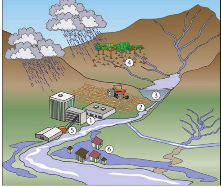
There are six main physical causes of flooding:
1. Extended periods of heavy rain including cyclones
When areas experience prolonged heavy rainfall, the ground becomes unable to absorb all the water. Tropical cyclones and severe storms can dump enormous amounts of rain in short periods, overwhelming natural drainage systems and causing rivers to burst their banks.
2. Steep mountain slopes that lead to high water run-off
On steep terrain, rainwater flows rapidly downhill rather than soaking into the ground. This creates fast-moving surface water that collects in valleys and river channels, causing water levels to rise quickly and leading to flash floods.
3. Saturated soil that prevents water infiltration
When soil becomes completely saturated with water, it cannot absorb any more moisture. Additional rainfall then flows over the surface as run-off, contributing directly to rising water levels in streams and rivers.
4. Volcanic eruptions that can melt ice or cause ash to dam rivers
Active volcanoes can trigger floods in several ways. Volcanic heat can rapidly melt snow and ice, creating sudden water surges. Additionally, volcanic ash and debris can block river channels, causing water to back up and eventually overflow.
5. Earthquakes that can cause tsunamis or divert rivers
Seismic activity can trigger devastating floods through tsunamis in coastal areas. Earthquakes can also alter river courses or create landslides that block waterways, leading to dangerous flooding when the temporary dams eventually break.
6. Flat land where rivers can naturally overflow
In low-lying, flat areas, rivers naturally tend to overflow their banks during high water periods. These floodplains are part of the river's natural system, but they become problematic when people build homes and infrastructure in these areas.
Human causes of floods
Human activities can significantly increase the likelihood and severity of flooding. Unlike natural causes, these are factors that people can potentially control or modify through better planning and environmental management.
Critical Understanding: Human activities don't usually cause floods directly, but they can make flooding much worse and more frequent. The key difference is that human causes can be managed and controlled through proper planning and policy.
The main human causes of flooding include:
1. Urban areas with rapid water run-off
Cities and towns create large areas of impermeable surfaces like concrete and asphalt. When it rains, water cannot soak into the ground and instead flows rapidly into storm drains and rivers, causing water levels to rise quickly.
2. Altering the shape of river channels
When people straighten rivers or change their natural course, it can cause water to flow faster and increase flood risk downstream. These modifications disrupt the river's natural ability to manage varying water levels.
3. Building dams that change natural river flow
While dams can help control flooding, they also create risks. Dam failures can cause catastrophic floods, and dams can alter natural flood patterns, sometimes making flooding worse in certain areas.
4. Deforestation and vegetation removal
Trees and plants naturally absorb large amounts of water and slow down surface run-off. When forests are cleared for agriculture or development, more water flows directly into rivers, increasing flood risk.
5. Destruction of wetlands
Wetlands act like natural sponges, absorbing excess water during heavy rains. When these areas are drained or filled for development, this natural flood control system is lost, increasing flood risk for surrounding areas.
6. Poverty and overpopulation leading people to live in flood risk areas
Economic pressures sometimes force people to build homes in areas prone to flooding, such as floodplains or low-lying coastal areas. This puts both people and property at greater risk during flood events.
Characteristics of river floods
Understanding river discharge
When a river floods, it overflows its banks because the river channel contains much more water than it normally carries. The amount of water flowing in a river is called discharge. During floods, rivers experience very high discharge levels.
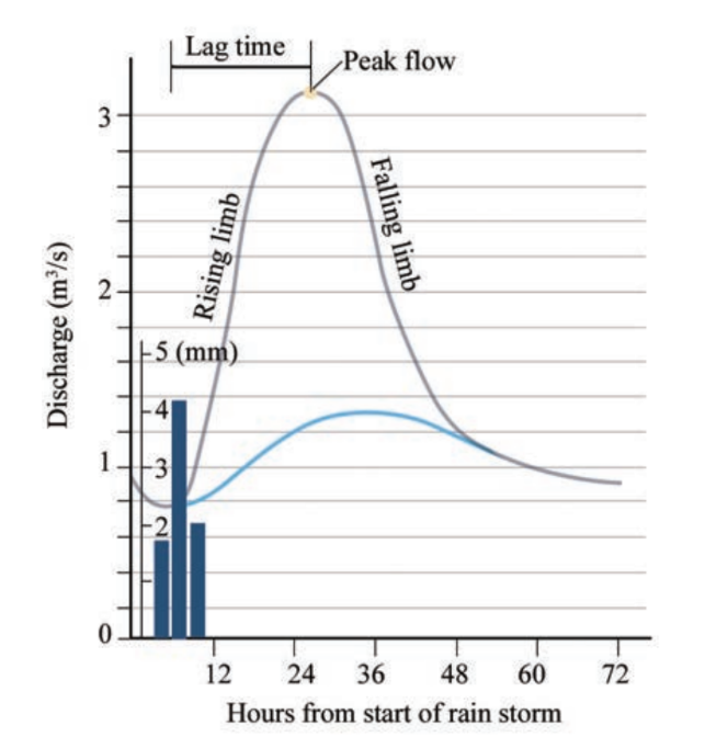
Discharge is measured as the volume of water passing a specific point in one second, typically expressed in cubic metres per second (m³/s). We can track how a river's discharge changes over time using a special graph called a hydrograph.
Think of discharge like traffic flow: Just as we can measure how many cars pass a point on a road per minute, discharge measures how much water passes a point in a river per second. During floods, it's like having a traffic jam of water!
Components of a hydrograph
A hydrograph shows how a river's discharge changes over time in response to rainfall. This tool helps us understand flood patterns and timing.
Understanding Hydrograph Components:
Base flow: The normal, everyday flow of the river when there is no recent rainfall
Peak discharge: The maximum amount of water flowing in the river during the flood event
Rising limb: The part of the graph that shows discharge increasing as rainwater reaches the river
Falling limb: The section showing discharge returning to normal levels after the flood peak
Lag time: The delay between when peak rainfall occurs and when the river reaches its maximum discharge
Factors affecting river discharge
Several factors influence how much water flows in a river and how quickly it responds to rainfall:
- Steepness of the land: Steep slopes cause water to reach rivers more quickly
- Land use: Urban areas and deforested regions increase the speed of water flow
- Basin shape: The overall shape of the river's drainage area affects how water collects
- Soil type: Different soils absorb water at different rates
- Vegetation cover: Plants slow down water flow and increase absorption
Common Exam Mistake: Students often confuse the causes of flooding with the factors that affect discharge timing. Remember that causes explain why floods happen, while factors affecting discharge explain how quickly and how much a river responds to rainfall.
Study tips for exams
Exam Success Tips:
When studying floods, practise interpreting hydrographs and identifying different flood causes from diagrams. Be able to explain the difference between physical and human causes, and understand how human activities can make natural flood risks worse.
Remember to use specific examples when discussing flood causes in exam answers, and always explain the processes involved rather than just listing factors.
Key Points to Remember:
-
Flooding occurs when water covers normally dry land - this can happen through river overflow or sea invasion
-
Physical causes are natural factors like heavy rain, steep slopes, saturated soil, volcanic activity, earthquakes, and flat terrain
-
Human activities increase flood risk through urbanisation, deforestation, wetland destruction, and poor land use planning
-
Hydrographs show how river discharge changes over time and help us understand flood timing and characteristics
-
The lag time between rainfall and peak discharge varies depending on factors like slope steepness, land use, and soil type