Rivers, Lakes, and Dams in South Africa (Grade 10 NSC Matric Geography): Revision Notes
Rivers, Lakes, and Dams in South Africa
Introduction to South Africa's water storage systems
South Africa's water resources come from both natural and artificial sources. Rivers and lakes serve as natural storage areas for fresh water, while people have built walls across rivers to create artificial lakes called dams. Since South Africa doesn't have many natural lakes, the construction of numerous dams across the country's rivers has become essential for water management and storage.
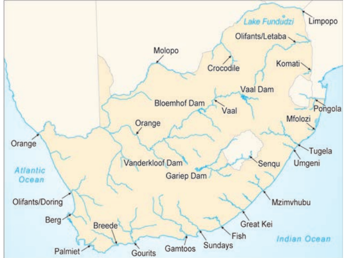
Interesting Fact: Lake Funduzi in the Venda region of Limpopo is one of the few natural lakes found in South Africa, making it quite unique in the country's landscape.
Factors affecting water availability in South Africa
Several key factors determine how much water is available across different regions of South Africa. Understanding these factors helps explain why some areas have abundant water while others face shortages.
Rainfall distribution patterns
Water reaches us primarily through rainfall, but this precipitation is not evenly spread across the country. The rainfall distribution refers to how rainfall varies from one area to another throughout South Africa.
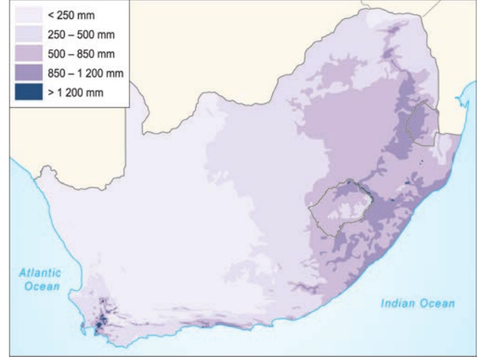
Looking at the rainfall patterns, you'll notice a clear divide:
Critical Rainfall Pattern:
- Eastern regions of South Africa receive substantial rainfall, with some areas getting more than 1,000mm per year
- Western regions are much drier, with some areas receiving less than 200mm annually
- The national average yearly rainfall is less than 500mm, which classifies South Africa as having a dry climate overall
This uneven distribution means that eastern provinces generally have better water security than western areas.
Evaporation rates and water loss
South Africa experiences high evaporation rates due to its climate conditions. During summer months, temperatures often exceed 30°C, and the country receives an average of 8.5 hours of sunshine daily. This combination of high temperatures and long sunshine hours creates ideal conditions for rapid water evaporation.
Critical Water Loss Statistic: Here's a striking statistic: only 8.6% of the rainfall that falls actually remains available as surface water in South African rivers and dams. The remaining water either evaporates back into the atmosphere or soaks into the soil.
Groundwater as a backup source
Fortunately, a significant amount of precipitation soaks into the ground and becomes groundwater. This underground water supply helps compensate for the high evaporation rates experienced above ground. People can access this groundwater resource by drilling wells and boreholes.
Impressive Groundwater Usage: The scale of groundwater use in South Africa is impressive:
- Approximately 1,000 new boreholes are drilled every week
- Currently, over 2,000 cubic metres of water are extracted from the ground through boreholes daily
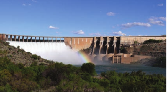
Water storage in dams
Since natural water storage is limited, South Africa relies heavily on dams built across rivers. These artificial reservoirs store water during rainy periods, making it available during drier times when communities and industries need it most.
South Africa's major dams
The following table shows South Africa's ten largest dams ranked by their storage capacity:
| Dam name | Province | Capacity (million cubic metres) |
|---|---|---|
| Gariep | Free State | 5,340 |
| Vanderkloof | Free State | 3,171 |
| Sterkfontein | Free State | 2,616 |
| Vaal | Free State | 2,603 |
| Pongolapoort | KwaZulu-Natal | 2,267 |
| Bloemhof | Free State | 1,240 |
| Theewaterskloof | Western Cape | 480 |
| Heyshope | Mpumalanga | 451 |
| Woodstock | KwaZulu-Natal | 373 |
| Loskop | Mpumalanga | 362 |
Key observations about South Africa's dams:
- Free State dominance: Five of the ten largest dams are located in the Free State province
- Gariep Dam supremacy: The Gariep Dam has by far the largest capacity at 5,340 million cubic metres
- Provincial distribution: Besides Free State (5 dams), KwaZulu-Natal has 2 dams, Mpumalanga has 2 dams, and Western Cape has 1 dam
- Capacity range: Storage capacity ranges from over 5,000 million cubic metres down to 362 million cubic metres
Important Dam Facts: More than 20% of South Africa's river flow is carried by the Gariep-Orange River system, highlighting the critical importance of this water source for the country.
The Vanderkloof Dam, which is the second largest in South Africa, also holds the record for having the highest dam wall at 108 metres.
Study Tips for Success:
When studying this topic, focus on understanding the relationships between different factors rather than just memorising facts. For example, consider how high evaporation rates make dam storage more important, or how uneven rainfall distribution affects where dams are built.
Practice reading and interpreting maps showing rainfall patterns and dam locations, as these skills are often tested in Geography examinations.
Key Points to Remember:
- South Africa has few natural lakes, making dams essential for water storage
- Only 8.6% of rainfall becomes available as surface water due to high evaporation rates
- Free State province contains five of the country's ten largest dams
- Gariep Dam is South Africa's largest water storage facility with 5,340 million cubic metres capacity
- Eastern areas receive much more rainfall than western regions, creating uneven water availability across the country