Number and Bar Scales (Grade 10 NSC Matric Mathematical Literacy): Revision Notes
Number and Bar Scales
What is scale?
Scale is the relationship between distances on a map or plan and the actual distances in real life. It tells us how many units in reality are represented by one unit on the map.
The scale helps us understand the size of objects and distances when they are drawn smaller than their actual size. For example, if a school building is 50 metres long in real life, it might only be 10 centimetres long on a map.
Understanding number scales
A number scale is written as a ratio, such as 1:50 or 1:500. This means that 1 unit on the map represents a specific number of units in real life.
For example:
- A scale of 1:40 means 1 cm on the map = 40 cm in real life
- A scale of 1:500 means 1 cm on the map = 500 cm (or 5 m) in real life
How to use number scales
To find the real distance when you have a number scale, follow these simple steps:
- Measure the distance on the map using a ruler
- Multiply that measurement by the scale factor (the number after the colon)
- Convert to appropriate units if needed
Essential Formula: Real distance = Map distance × Scale factor
This is the most important formula for working with number scales!
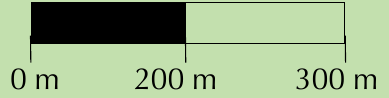
Understanding bar scales
A bar scale is a visual ruler that shows actual distances. It looks like a horizontal bar divided into segments, with each segment representing a specific distance in real life.
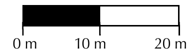
Bar scales are particularly useful because they provide a visual reference that you can use directly with your ruler. Each segment of the bar represents a particular distance in real life. To use a bar scale, you measure how many segments fit into the distance you want to find, then multiply by the value of each segment.
How to use bar scales
To find the real distance using a bar scale, follow these steps:
- Use your ruler to measure one segment of the bar scale
- Measure the distance you want to find on the map
- Calculate how many segments fit into that distance
- Multiply the number of segments by the distance each segment represents
Essential Formula: Real distance = Number of segments × Distance per segment
Remember to be careful with your measurements when counting segments!
Worked Example: Using Number Scales
Question: You have a map with a number scale of 1:40. You measure a length of 10 cm on the map. What is the real distance?
Solution:
- Scale: 1:40
- Map distance: 10 cm
- Real distance = 10 cm × 40 = 400 cm = 4 m
Worked Example: Using Bar Scales
Question: You have a bar scale where each segment represents 50 m. You measure a distance of 15 cm on the map, and each segment is 1.5 cm long. What is the real distance?
Solution:
- Length of one segment = 1.5 cm
- Distance measured = 15 cm
- Number of segments = 15 ÷ 1.5 = 10 segments
- Real distance = 10 × 50 m = 500 m
Worked Example: School Map Measurements
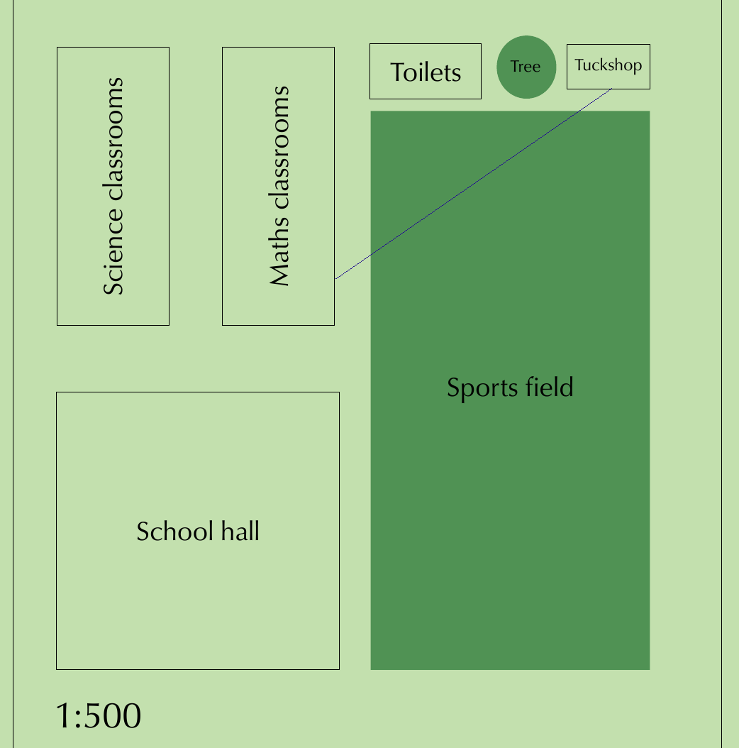
Question: Using the school map with scale 1:500, calculate the real length of the sports field if it measures 5 cm on the map.
Solution:
- Map measurement = 5 cm
- Scale = 1:500
- Real distance = 5 cm × 500 = 2500 cm = 25 m
Worked Example: Room Floor Plan
Question: Using the room plan shown, calculate the real length of the couch if the bar scale shows 1 cm = 20 cm.
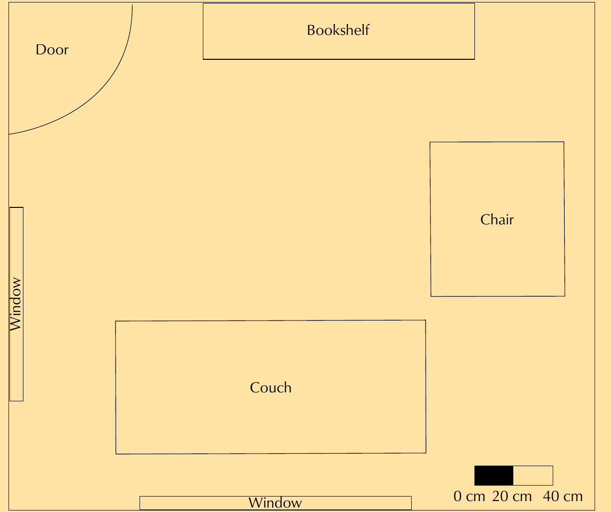
Solution:
- Measure the couch on the map = 8 cm
- Scale shows 1 cm = 20 cm
- Real length = 8 cm × 20 cm = 160 cm = 1.6 m
Advantages and disadvantages of each scale type
Understanding when to use each type of scale is important for accurate measurements and map reading.
Number scales
Advantages:
- Simple to use - only need to multiply by one number
- Quick calculations with just basic arithmetic
- Takes up less space on the map
Disadvantages:
- Becomes inaccurate if the map is photocopied or resized
- Scale changes when map size changes
- Can be difficult to visualize actual distances
Bar scales
Advantages:
- Remains accurate even when maps are resized or photocopied
- Visual and easy to understand - provides immediate reference
- Always shows correct proportions regardless of map size
Disadvantages:
- Requires more complex calculations
- Need to measure and count segments carefully
- Takes up more space on the map
When to choose each scale type: Use number scales for simple, one-off calculations when you know the map won't be resized. Use bar scales when accuracy is critical or when the map might be photocopied or resized.
Drawing scaled maps from real dimensions
When you need to create your own map or plan, you work backwards from real measurements to create scaled measurements that fit on your paper.
Steps to draw a scaled map:
The process involves several important steps that must be followed in order:
- Choose an appropriate scale (e.g., 1:50) based on your paper size and the real area
- Convert all real measurements to the same units (usually centimetres)
- Divide each real measurement by the scale factor
- Draw using the calculated scaled measurements
- Always include the scale on your drawing
Critical Step: Always include the scale on any map or plan you draw. Without the scale, your drawing cannot be used to calculate real distances!
Worked Example: Drawing a Scaled Room
Question: Draw a scaled map of a room that measures 3 m by 4.5 m using a scale of 1:50.
Solution:
- Room width: 3 m = 300 cm
- Scaled width: 300 ÷ 50 = 6 cm
- Room length: 4.5 m = 450 cm
- Scaled length: 450 ÷ 50 = 9 cm
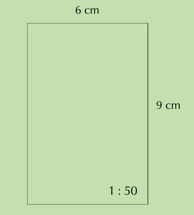
The room should be drawn as a 6 cm by 9 cm rectangle with the scale 1:50 marked on it.
Key Points to Remember:
- Scale shows the relationship between map distances and real distances
- Number scales are written as ratios (1:50) - multiply map measurement by the scale factor
- Bar scales are visual rulers - count segments and multiply by segment value
- Number scales become inaccurate when maps are resized, but bar scales remain accurate
- Always check your units - convert between mm, cm, and metres as needed
- Always include the scale on any map or plan you draw
- Use the formula: Real distance = Map distance × Scale factor for number scales
- Use the formula: Real distance = Number of segments × Distance per segment for bar scales