Distance (Grade 11 NSC Matric Geography): Revision Notes
Distance
What is ground distance?
Ground distance refers to the actual distance between two points on the Earth's surface. When we use maps, we need to convert the measurements we take on the map into real-world distances. This is essential for planning journeys, understanding the true scale of geographical features, and making practical decisions based on map information.
Maps are scaled-down representations of reality, so a centimetre on a map represents a much larger distance in the real world. The key to successful mapwork is understanding how to make these conversions accurately.
Distance measurement is one of the most practical skills in geography - you'll use it for planning trips, understanding news reports about distances, and in many careers including emergency services, tourism, and urban planning.
Understanding map scales
Different types of maps use different scales, which affects how we calculate distances. The two main types you'll encounter are:
Topographic maps
These detailed maps typically use a scale of 1:50,000. This means:
- 1 centimetre on the map = 0.5 kilometres (500 metres) on the ground
- The conversion formula is:
Orthophoto maps
These aerial photograph maps use a scale of 1:10,000. This means:
- 1 centimetre on the map = 0.1 kilometres (100 metres) on the ground
- The conversion formula is:
Always check the map scale before starting any calculation! Using the wrong scale is one of the most common mistakes in distance measurement. Look for the scale information in the map legend or corner.
Measuring straight line distances
For features that follow a direct path between two points, measuring distance is straightforward:
- Use a ruler to measure the distance on the map in centimetres
- Apply the appropriate formula based on your map scale
- Convert to the required units (kilometres, metres, etc.)
This method works well for measuring distances between cities, the width of lakes, or any other direct measurements where you can draw a straight line between two points.
Worked Example: Measuring Distance Between Cities
Step 1: Measure the distance on a 1:50,000 topographic map Distance on map = 6.4 cm
Step 2: Apply the formula Distance on ground = 6.4 cm × 0.5 = 3.2 km
Step 3: Convert if needed The cities are 3.2 kilometres apart (or 3,200 metres)
Measuring curved features
Many geographical features don't follow straight lines. Rivers wind through landscapes, coastlines have irregular shapes, and roads curve around obstacles. For these features, we need a different approach.
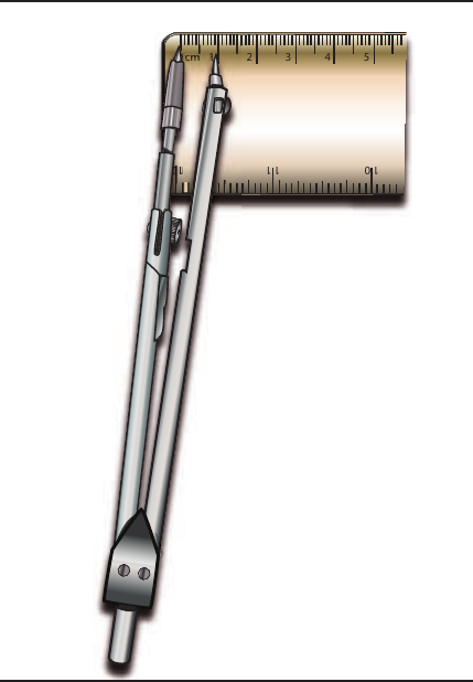
Using dividers (compass tool)
The most accurate way to measure curved distances is using a pair of dividers or a compass:
- Set the divider points approximately 1 cm apart on a ruler - the closer together they are, the more accurate your measurement will be
- Place one point at the beginning of the feature you want to measure
- "Walk" the dividers along the curved line, lifting and placing the second point repeatedly
- Count the number of segments as you follow the entire curve
- Measure the total distance by placing the dividers on the bar scale
This technique allows you to follow the exact path of winding rivers, meandering roads, or irregular coastlines, giving you a much more accurate measurement than attempting to estimate with straight-line segments.
The process requires patience and practice, but it's the most reliable method for measuring curved features on both topographic and orthophoto maps.
Worked Example: Measuring a Winding River
Step 1: Set dividers to 0.5 cm apart on ruler Step 2: Start at river source, "walk" dividers along entire river course Step 3: Count segments - river took 14 segments of 0.5 cm each Step 4: Total map distance = 14 × 0.5 = 7 cm Step 5: Convert using 1:50,000 scale = 7 × 0.5 = 3.5 km
The river is 3.5 kilometres long following its winding path.
Practical applications
Understanding distance measurement is crucial for:
- Route planning: Calculating journey times and fuel requirements
- Emergency services: Determining response times and coverage areas
- Environmental studies: Measuring river lengths, coastal erosion, or habitat sizes
- Urban planning: Assessing development impacts and infrastructure needs
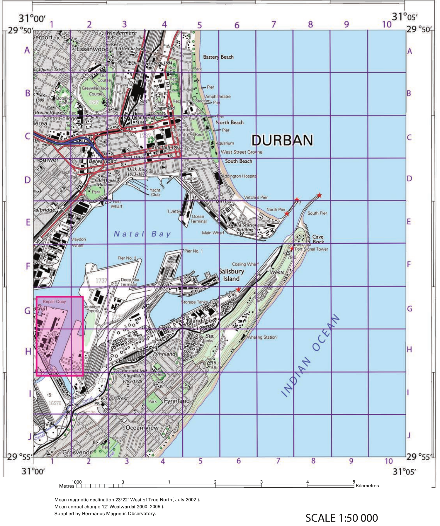
Maps like this topographic map of Durban provide excellent opportunities to practice distance measurements between various landmarks, along the coastline, and through the urban areas.
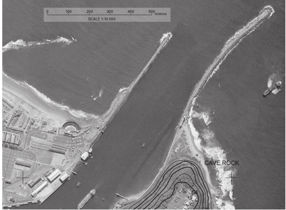
Orthophoto maps offer a different perspective, showing the same area with photographic detail that can help you understand the terrain you're measuring across.
Real-world relevance: The skills you're learning here are used daily by professionals in many fields. Emergency responders use these techniques to plan optimal routes, environmental scientists measure habitat areas, and urban planners assess development impacts.
Common Exam Mistakes to Avoid:
- Forgetting to check the map scale before calculating
- Using the wrong conversion factor (0.5 vs 0.1)
- Not showing your working clearly
- Mixing up units (kilometres vs metres)
- Rushing the dividers method for curved features
Key Points to Remember:
- Ground distance is the real-world distance between points on Earth's surface
- Topographic maps (1:50,000): 1 cm = 0.5 km, so multiply your measurement by 0.5
- Orthophoto maps (1:10,000): 1 cm = 0.1 km, so multiply your measurement by 0.1
- Use rulers for straight lines and dividers for curved features like rivers and coastlines
- Always check the map scale first before making any distance calculations
- Show all working in exams and double-check your units
- Take your time with curved measurements - accuracy is more important than speed