Topography – Horizontally Layered Rocks (Grade 11 NSC Matric Geography): Revision Notes
Horizontally Layered Rocks – Characteristics, Processes, and Utilisation
Introduction to horizontally layered rocks
Horizontally layered rocks create some of the most distinctive and dramatic landscapes on Earth. When these rock layers are arranged parallel to the horizon, they form characteristic flat-topped landforms that stand out prominently in arid and semi-arid regions. The key to understanding these landscapes lies in recognizing that different rock layers have varying levels of resistance to weathering and erosion processes.
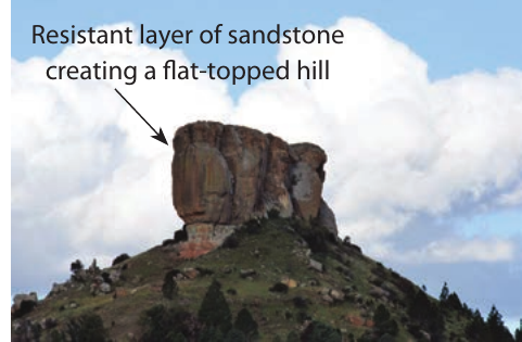
The formation of flat-topped hills occurs when a more resistant layer of rock sits on top of less resistant layers beneath it. Because the upper layer resists weathering and erosion more effectively than the softer rocks below, it acts like a protective cap, preventing the underlying materials from being worn away as quickly. This creates the distinctive flat-topped appearance that characterizes these geological formations.
The process of differential erosion is fundamental to understanding horizontally layered rock landscapes. Different rock types erode at different rates, with harder rocks forming caps that protect softer rocks beneath, creating the dramatic flat-topped hills characteristic of these regions.
Unit 1: Characteristics and processes associated with the development of hilly landscapes
Formation mechanisms of flat-topped hills
Flat-topped hills develop through three main geological processes, each creating similar-looking landforms but through different formation mechanisms. Understanding these processes helps explain why certain areas of the world display such dramatic flat-topped topography.
Horizontally laid sedimentary rock formations
Sedimentary rocks form in layers over millions of years, with different types of sediments creating layers with varying resistance to weathering. When these layers remain horizontal and are exposed to surface processes, differential erosion begins to shape the landscape.
In areas where shale (a softer sedimentary rock) lies beneath sandstone (a more resistant sedimentary rock), the shale erodes much faster than the sandstone above it. This creates situations where the sandstone layer forms a protective cap over the softer materials below, resulting in flat-topped hills with steep sides.
Formation Process: Sedimentary Rock Layers
Step 1: Layer deposition - Different sedimentary rocks form in horizontal layers over millions of years
Step 2: Exposure - Geological processes expose these layers to surface weathering
Step 3: Differential erosion - Softer shale erodes faster than resistant sandstone above
Step 4: Cap formation - Sandstone layer protects underlying materials, creating flat-topped hills
The geological cross-section reveals how these different rock layers interact with erosional processes. Areas with less resistant rock experience more rapid weathering and erosion, while the resistant layers remain as elevated features in the landscape.
Igneous intrusions and sill formations
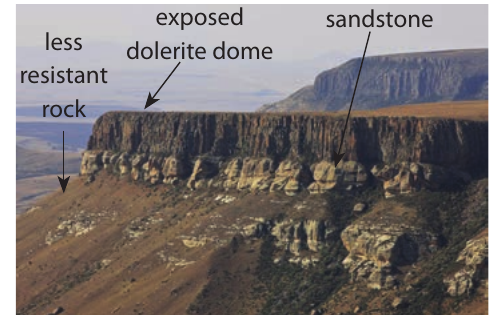
The second way flat-topped hills form involves igneous intrusions called sills. When very hot magma forces its way between existing layers of sedimentary rock and then cools and solidifies, it creates an igneous rock layer sandwiched between sedimentary layers. In South Africa, many of these sills consist of dolerite, which typically proves more resistant to erosion than the surrounding sedimentary rocks.
When these geological formations become exposed at Earth's surface through various processes, the igneous sill resists erosion more effectively than the sedimentary rocks around it. This creates flat-topped hills where the resistant igneous layer forms the summit, while the less resistant sedimentary rocks below erode away more rapidly.
Formation Process: Igneous Sill Development
Step 1: Magma intrusion - Hot magma forces between sedimentary rock layers
Step 2: Cooling and solidification - Magma cools to form resistant igneous rock (e.g., dolerite)
Step 3: Surface exposure - Geological processes expose the sill at Earth's surface
Step 4: Differential erosion - Resistant igneous layer protects softer rocks beneath
Lava flows and basaltic plateaus
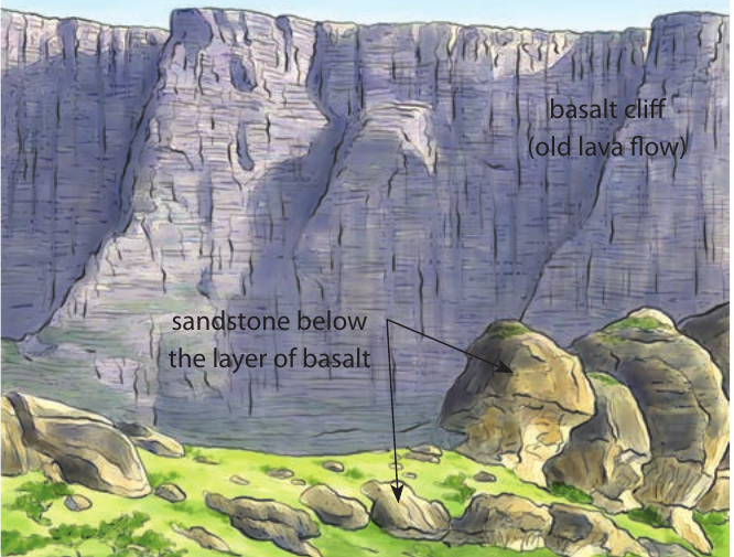
The third formation mechanism involves ancient lava flows that created extensive flat areas known as basaltic plateaus. Basaltic lava possesses very fluid properties, allowing it to flow across Earth's surface and spread out over vast areas covering thousands of square kilometres. When this lava cools and solidifies, it forms a large flat area composed of basalt rock.
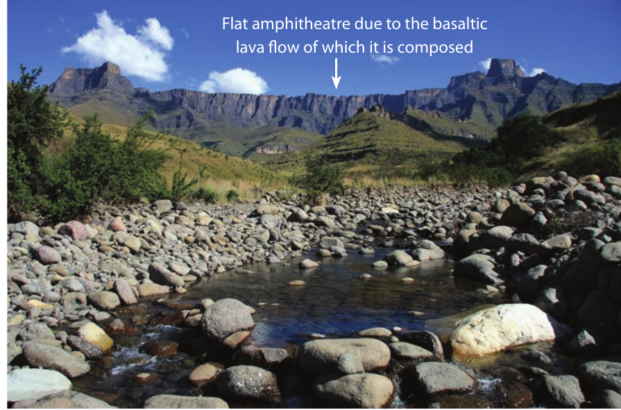
Basaltic plateaus and canyon landscapes
Basaltic plateaus create unique landscape characteristics because basalt rock demonstrates exceptional resistance to weathering and erosion processes. This resistance means that very few rivers can successfully carve valleys through these plateau surfaces. However, the few rivers that do manage to flow across these plateaus create deep, narrow valleys called canyons due to the concentrated erosive power needed to cut through such resistant rock.
Canyon Definition: Any deep, narrow valley in an arid area receives the designation of canyon. Rivers that create canyons typically originate in areas with higher rainfall and flow into drier regions, carrying sufficient water volume to erode through resistant rock layers over extended time periods.
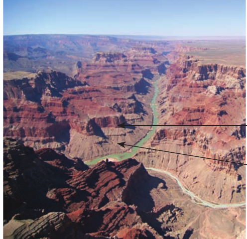
The formation process involves rivers gradually cutting downward through multiple layers of sedimentary rock, each layer displaying different resistance levels to weathering and erosion. More resistant rock layers create steep canyon walls, while softer rock layers experience faster erosion, creating more gentle slopes within the canyon system.
Canyon formation represents a long-term process where rivers continue cutting deeper into plateau surfaces over millions of years. In arid and semi-arid regions, limited surface water runoff means that canyon walls widen very slowly through back wasting processes, maintaining their characteristic steep-sided, narrow profile for extended periods.
Karoo landscapes and landform evolution
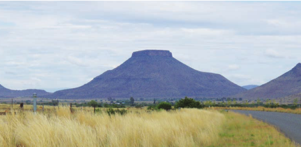
Karoo landscapes demonstrate the evolutionary sequence that occurs when horizontally layered rocks undergo long-term erosional processes. These landscapes typically display concave slopes leading up to flat-topped hills, a characteristic feature of arid and semi-arid environments where limited rainfall results in minimal surface water runoff.
The evolutionary sequence follows a predictable pattern: plateau → mesa → butte → conical hill. This progression occurs because weathering and erosion gradually reduce the size of flat-topped landforms over geological time scales.
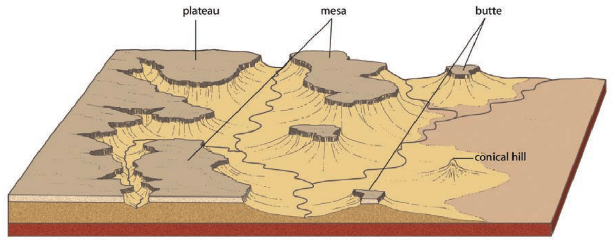
Understanding the landform sequence
Plateau stage: Large, extensive flat-topped areas represent the initial stage of this evolutionary sequence. Plateaus maintain their flat surfaces because resistant rock layers protect underlying softer materials from erosion.
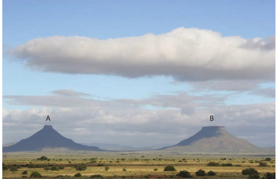
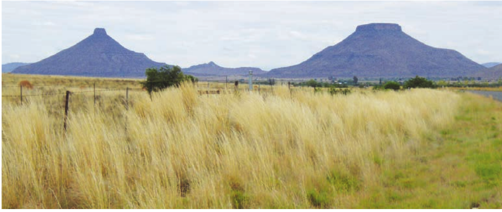
Mesa development: When the distance across the top of a flat-topped hill exceeds the height of the hill itself, geographers classify it as a mesa. Mesas form as plateaus undergo continued erosion around their edges, gradually reducing their overall size while maintaining their flat-topped character.
Butte formation: Continued erosional processes eventually reduce mesas to smaller flat-topped hills called buttes. A butte differs from a mesa in that its distance across the top becomes less than its total height, indicating advanced stages of erosional reduction.
Conical hill development: Eventually, all resistant cap rock undergoes complete removal through weathering and erosion processes. When this occurs, the remaining softer rock forms rounded hills known as conical hills, representing the final stage in this evolutionary sequence.
The classification between mesa and butte depends on the relationship between width and height: if the top is wider than the height, it's a mesa; if the top is narrower than the height, it's a butte.
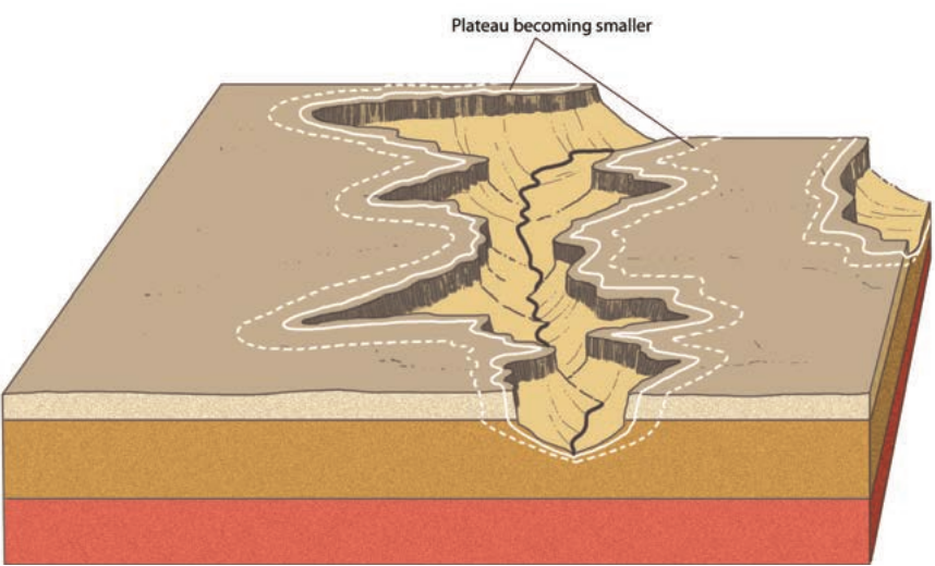
Unit 2: Scarp retreat and back wasting processes
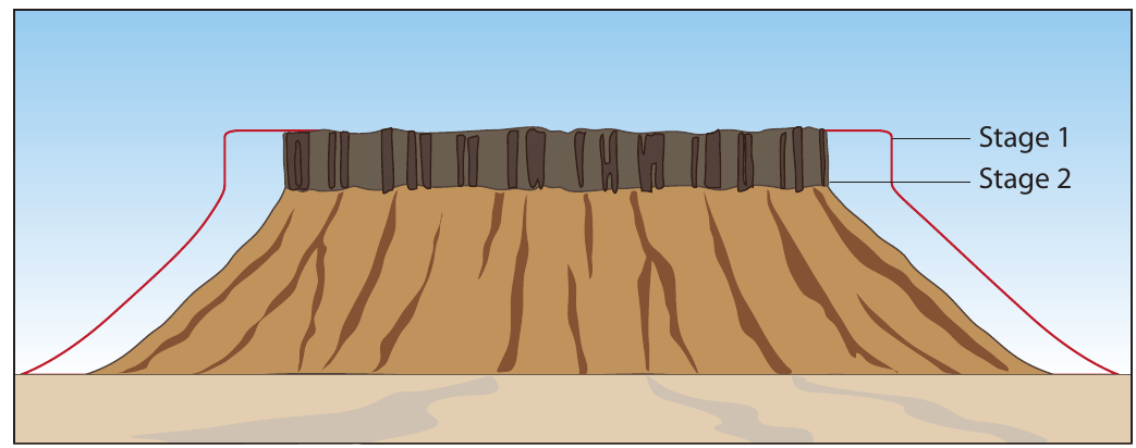
Karoo landscapes typically undergo gradual modification through a process called scarp retreat or back wasting. This erosional mechanism occurs commonly in dry climates where limited surface water runoff creates specific conditions for slope development and modification.
Understanding scarp retreat mechanisms
The scarp retreat process operates through two distinct stages that work together to modify landscape features over time. During the first stage, pieces of rock break away from cliff faces and collect on talus slopes below. These rock fragments undergo relatively rapid breakdown because they exist in already fragmented conditions, allowing weathering processes to act more effectively.
Key Characteristic of Scarp Retreat: The angle of talus slopes remains parallel to the original cliff position throughout this process. This parallel relationship represents a key characteristic of back wasting in arid environments, where mechanical weathering dominates over chemical weathering processes.
During the second stage, both scarp retreat and parallel back wasting continue simultaneously. The plateau area decreases in size as erosional processes work on the cliff faces, but both the cliff (scarp) and the talus slope maintain consistent angles throughout the process. This creates the characteristic stepped appearance of evolving landforms in arid environments.
Unit 3: Utilisation of landscapes by people
Landscapes formed from horizontally layered rocks in arid regions present limited economic opportunities due to several environmental constraints. However, these areas do offer some specific uses and economic potential under certain circumstances.
Agricultural limitations and opportunities
The arid climate conditions that characterize these landscapes make traditional crop farming virtually impossible. However, limited pastoral activities can occur in specific locations within these landscapes. Sheep farming and goat farming represent the most viable agricultural activities, typically taking place either on plateau surfaces or on pediment areas where mesas and buttes have developed.
Agricultural Constraints: These pastoral activities remain restricted in scope because the harsh climate conditions and limited water availability constrain the carrying capacity of the land. The steep terrain and difficulty accessing water sources further limit agricultural development potential.
Transportation and infrastructure challenges
Developing transportation networks in these landscapes presents significant engineering challenges. The deep canyons and steep cliff faces make road and railway construction extremely expensive, requiring elaborate bridge systems to span the dramatic topographic features.
Limited transportation infrastructure restricts economic development opportunities and makes these areas relatively isolated from major economic centers. This isolation contributes to the limited economic utilization of these dramatic landscapes.
Tourism and scenic attractions
Despite agricultural and transportation limitations, these landscapes possess significant potential as tourist attractions. The dramatic scenery created by flat-topped hills, deep canyons, and stark arid beauty appeals to visitors interested in natural landmarks and geological features.
Tourism Potential: Canyons particularly attract tourists due to their spectacular scenic qualities. These natural formations provide opportunities for tourism-based economic development, though this requires careful management to balance economic benefits with environmental conservation needs.
Several well-known examples demonstrate the tourism potential of these landscapes. Canyon systems in various parts of the world have become major tourist destinations, generating significant economic benefits for local communities while showcasing the remarkable geological processes that create these distinctive landforms.
Key Points to Remember:
- Three formation mechanisms: Flat-topped hills form through horizontally laid sedimentary rocks, igneous sills, or ancient lava flows creating basaltic plateaus
- Landform evolution sequence: Landscapes progress from plateau → mesa → butte → conical hill through continued erosional processes
- Scarp retreat process: In arid climates, slopes erode back parallel to their original positions while maintaining consistent angles, creating the characteristic stepped landscape appearance
- Canyon formation: Rivers flowing from wet to dry areas can cut deep, narrow valleys through resistant rock layers, creating dramatic canyon landscapes
- Limited economic use: These landscapes offer restricted agricultural potential but can provide valuable tourism opportunities due to their dramatic scenic qualities