Topography – Massive Igneous Rocks (Grade 11 NSC Matric Geography): Revision Notes
Batholiths, Laccoliths, Lopoliths, Dykes, and Sills
Understanding massive igneous rocks
Massive igneous rocks are formed when molten magma solidifies underground or on the surface. These rocks cover vast areas and have distinctive characteristics that set them apart from other rock types. They lack any internal layering and display a uniform color and texture throughout their structure.
The formation process of massive igneous rocks is closely linked to how quickly they cool. When magma cools very slowly deep underground, it forms large, coarse crystals. However, when cooling happens closer to the surface, the process is much faster, resulting in smaller crystals and a finer texture. This relationship between cooling rate and crystal size is fundamental to understanding igneous rock formation.
The cooling rate of magma directly determines the crystal size in igneous rocks. This principle helps geologists understand where and how different igneous rocks formed by examining their crystal structure under a microscope.
Types of intrusive igneous features
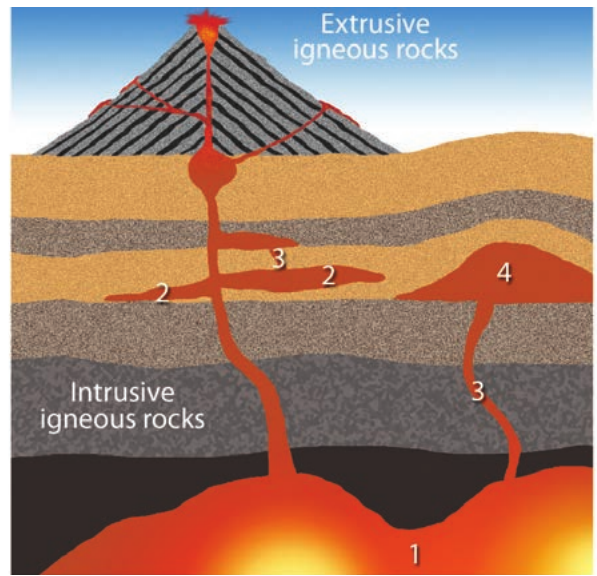
When magma solidifies beneath the Earth's surface, it creates various types of intrusive igneous features. Each type has a unique shape and formation process, which influences the landforms they create when eventually exposed at the surface.
Batholiths
The term "batholith" comes from two Greek words: "bathos" meaning depth and "lithos" meaning rock. This name perfectly describes these massive underground rock formations, as they are the largest and deepest of all intrusive igneous features.
Batholiths form when enormous amounts of magma solidify very deep underground. They typically have a surface area larger than 100 square kilometers, but many extend for thousands of square kilometers. What makes batholiths particularly interesting is that they appear to have no bottom - they extend so deep that their base has never been found.
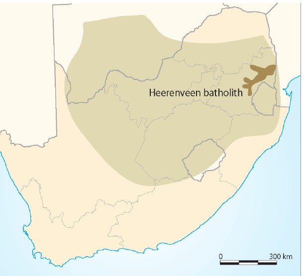
Real-World Example: Heerenveen Batholith
The Heerenveen Batholith in the Barberton region of Mpumalanga, South Africa provides an excellent case study. This massive rock formation:
- Developed approximately 3,105 million years ago
- Demonstrates the enormous scale that batholiths can achieve
- Shows how these ancient formations can still be studied today
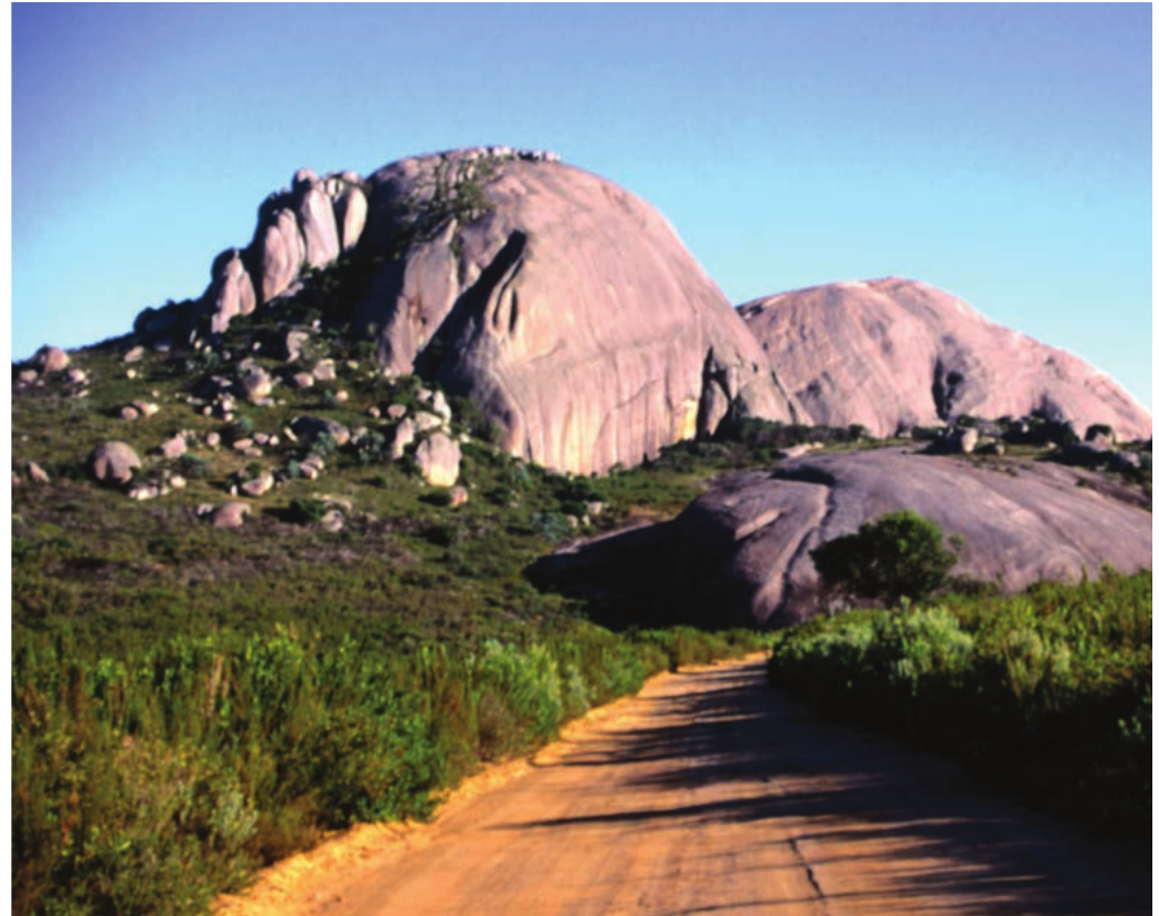
When batholiths are eventually exposed at the Earth's surface through erosion of overlying rocks, they typically form distinctive dome-shaped landforms. These domes develop through a weathering process called exfoliation.
Lopoliths
The word "lopolith" originates from the Greek words "lopas" (meaning dish or bowl) and "lithos" (meaning rock). This name describes the characteristic dish or saucer shape that these intrusions take underground.
Lopoliths form when magma is squeezed between layers of existing rock deep underground. The immense heat and pressure from the large body of magma causes the underlying rocks to sag downward, allowing the magma to cool and solidify in this distinctive bowl-like shape.
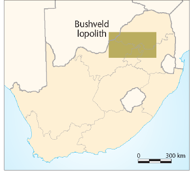
Real-World Example: Bushveld Igneous Complex
The Bushveld Igneous Complex in South Africa provides an excellent example of a lopolith:
- Location: North of the Magaliesberg, between Brits and Rustenburg
- Economic importance: Contains rich deposits of chrome and platinum-group metals
- Demonstrates the valuable mineral resources often associated with lopoliths
Like batholiths, when lopoliths are exposed at the surface, they also form dome-shaped landforms through the same exfoliation weathering process.
Laccoliths
The term "laccolith" comes from the Greek words "lakkos" (meaning pond) and "lithos" (meaning rock). This name reflects the way these intrusions form underground.
Laccoliths develop when magma is squeezed between rock layers relatively close to the Earth's surface. The pressure and heat from the magma cause the overlying rocks to buckle upward, creating a mushroom-like shape as the magma cools and solidifies.
When laccoliths are eventually exposed at the surface through erosion, they too form dome-shaped landforms, similar to batholiths and lopoliths.
All three large intrusive features (batholiths, laccoliths, and lopoliths) create the same type of surface landform - domes - despite having completely different underground shapes. This occurs because they all undergo the same weathering processes due to their massive size.
Sills
A sill forms when a thin layer of very liquid magma is forced between horizontal layers of sedimentary rock. The magma cannot bend or break through these layers, so it cools in a horizontal position between the existing rock layers.
Dolerite is the most common type of rock found in sills. This rock type is particularly important because it is more resistant to erosion than many surrounding sedimentary rocks. When sills are eventually exposed at the Earth's surface, they create several distinctive landforms.
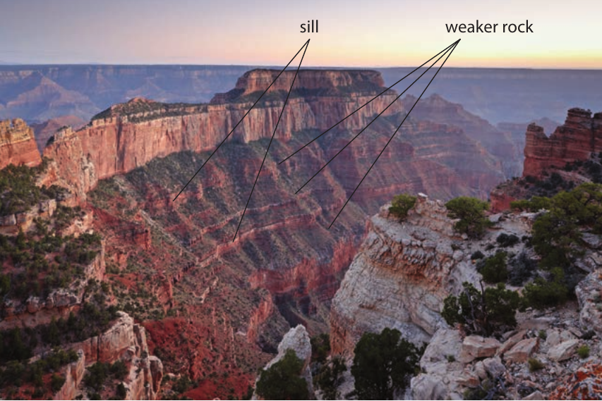
The most common landforms created by exposed sills are structural terraces, mesas, and buttes. These form because the resistant dolerite rock protects the layers of rock beneath it from erosion. When exposed on the side of a hill, sills create stepped slopes called structural terraces. Over time, as erosion continues, mesas (flat-topped hills) are formed, which may eventually be reduced to smaller buttes.
Dykes
A dyke forms in a similar way to a sill, but the magma forces its way up through vertical cracks in the rock and solidifies in an upright position, almost like a wall underground.
When dykes are eventually exposed at the Earth's surface, they can form two different types of landforms, depending on their resistance to weathering compared to the surrounding rocks.
If the dyke rock is more resistant than the surrounding rocks, it will form a low, narrow ridge called a serrated ridge when exposed on the surface. However, if the dyke rock is less resistant than the surrounding rock, it will erode away more quickly, creating a groove or valley called a portal.
Weathering and landform development
The process by which these intrusive igneous features become exposed landforms involves the gradual removal of overlying rock through erosion. Once exposed, they undergo specific weathering processes that shape their final appearance.
Exfoliation is the key weathering process that affects the larger intrusive features (batholiths, laccoliths, and lopoliths). This mechanical weathering process occurs when rock particles expand during hot days and contract during cool nights. Over time, this constant expansion and contraction causes the outer layers of rock to peel off, gradually rounding the rocks and creating the characteristic dome shapes we observe.
The smaller intrusive features (sills and dykes) create different landforms because of their different shapes and orientations. Sills, being horizontal, protect underlying rocks and create stepped landscapes, while dykes, being vertical, either stand out as ridges or erode to form valleys depending on their resistance to weathering.
The exfoliation process is similar to how an onion's layers peel away. Temperature changes cause the rock to expand and contract repeatedly, eventually causing the outer "layers" to separate and fall away, creating the smooth, rounded dome shapes we see today.
Summary of intrusive features and their landforms
Understanding the relationship between intrusive igneous bodies and their resulting surface landforms is crucial for recognizing these features in the landscape. The three large intrusive features - batholiths, laccoliths, and lopoliths - all create dome-shaped landforms when exposed, despite their different underground shapes. This similarity occurs because they all undergo the same exfoliation weathering process due to their massive size and granite composition.
In contrast, the smaller intrusive features create more varied landforms. Sills create distinctive stepped landscapes that preserve underlying rocks, while dykes create either raised ridges or eroded valleys depending on their resistance compared to surrounding rocks.
These relationships help geographers and geologists identify the underlying rock structures by observing surface landforms, making it possible to understand the geological history of an area through careful landscape observation.
Key Points to Remember:
-
Massive igneous rocks form when magma cools and solidifies, with slower cooling creating larger crystals and faster cooling creating smaller crystals
-
The three large intrusive features (batholiths, laccoliths, lopoliths) all form dome-shaped landforms when exposed due to exfoliation weathering, regardless of their different underground shapes
-
Sills create protective stepped landscapes because the resistant dolerite rock shields underlying sedimentary layers from erosion, forming structural terraces, mesas, and buttes
-
Dykes form either ridges or valleys when exposed - ridges when the dyke is more resistant than surrounding rock, valleys (portals) when it's less resistant
-
Greek word origins help remember shapes: bathos (depth), lopas (dish), lakkos (pond), which describe the underground forms of these intrusive features