Evidence of Soil Erosion in South Africa (Grade 11 NSC Matric Geography): Revision Notes
Evidence of Soil Erosion in South Africa
Introduction
Soil erosion affects most regions across South Africa, with the most severely impacted areas found in the drier western regions of the country. Understanding this environmental challenge requires examining real-world examples and scientific evidence that demonstrate both the causes and consequences of soil degradation.
Soil erosion is a widespread environmental issue in South Africa, requiring scientific investigation to understand its patterns, causes, and long-term impacts on agricultural productivity and landscape stability.
Case study: Soil erosion in the Karoo near Graaff-Reinet
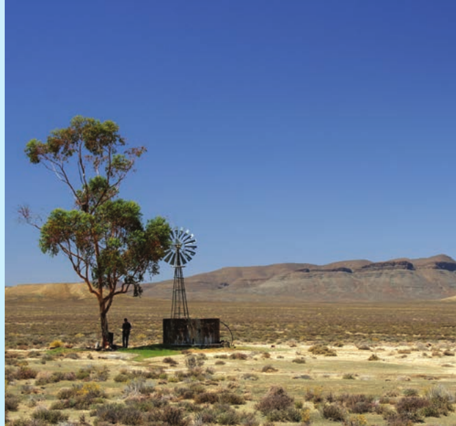
An international team of researchers conducted an investigation into the severely degraded farmland located in the Klein Seekoei valley, situated north of Graaff-Reinet in the Eastern Cape province. This region, similar to many areas throughout the Karoo, has experienced significant soil erosion connected to excessive grazing and intensive farming practices.
Research methods employed
Scientific Approach to Soil Erosion Research
The research team employed multiple complementary methods to build a comprehensive understanding of erosion patterns and their historical development over several decades.
The scientific team used several different approaches to gather comprehensive evidence:
- Analysis of aerial photographs spanning from 1945 to 2000
- Investigation of sediment deposits in local dams
- Conducting interviews with local farmers
- Performing experiments that simulate erosion processes
- Collecting soil samples from various locations across the study area
Key Word: Simulate - reproduce the essential features of something as an aid to study
Historical changes revealed through aerial photography
The examination of aerial photographs provided striking evidence of environmental change over time. Historical images from the 1940s revealed extensive vegetation cover across the landscape, showing active wheat cultivation in the valley areas. However, aerial photographs from the 1990s demonstrated that these same areas had become virtually bare of vegetation and had been completely abandoned by farmers.
The contrast between 1940s and 1990s aerial photographs shows a dramatic transformation from thriving agricultural land with extensive vegetation cover to completely barren, abandoned farmland - clear visual evidence of severe environmental degradation.
Interviews with local farmers supported these visual findings. They explained that during the 1930s, the valley floors supported thriving wheat farms, and farmers maintained much larger sheep populations on the hillsides compared to current practices. When researchers examined the landscape directly, they observed clear signs of severe gully erosion, providing evidence that soil loss had been occurring over an extended period.
Sediment analysis findings
The research team analyzed sediment layers in two different farm dams to understand erosion patterns over time. They used scientific techniques to determine the age of mineral deposits in the sediments, creating a timeline of soil erosion events.
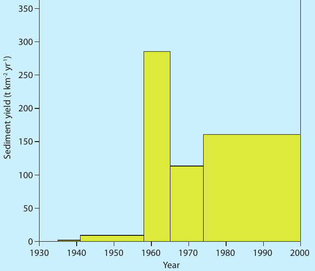
Dam 1 Sediment Analysis Results
Timeline of sediment accumulation:
- 1930s-1950s: Very low sediment levels (baseline period)
- 1960-1965: Enormous spike to approximately 290 tonnes per km² per year
- 1965-2000: Elevated but reduced levels at around 160 tonnes per km² per year
This pattern shows a dramatic acceleration of soil erosion beginning in the 1960s, with persistently high rates continuing for decades.
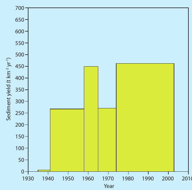
Dam 2 Sediment Analysis Results
Correlation with sheep grazing intensity:
- Late 1930s: Maximum sheep grazing period begins
- 1940s: Sediment levels reach 270 units
- 1960s: Increased accumulation to 450 units
- 1980-2000: Highest levels of approximately 470 units
Key finding: Even after sheep numbers were significantly reduced, sediment levels remained elevated, indicating long-term landscape damage.
What the evidence reveals
After analyzing all available information, the research team reached several important conclusions:
Critical Research Findings
The landscape has been severely destabilized through excessive grazing and intensive crop cultivation. Rainfall provides the energy that transports sediment particles from hillsides into valleys and drainage channels. Most of the sediment material that accumulates in dams consists of valuable topsoil that has been stripped from the land surface. Periods when vegetation is destroyed through burning coincide with times of increased soil erosion activity.
Perhaps most concerning was the team's observation that despite some areas being completely abandoned and dramatic reductions in livestock numbers, soil erosion processes continue to operate. This suggests that once severe degradation occurs, the landscape struggles to recover naturally, even when the original pressures are removed.
Remember!
Key Points to Remember:
- South Africa experiences widespread soil erosion, particularly in drier western regions
- The Karoo case study demonstrates how scientific methods can reveal long-term environmental changes
- Aerial photographs provide powerful evidence of landscape transformation over decades
- Sediment analysis in dams creates a historical record of erosion events
- Overgrazing and overcultivation are major contributors to soil degradation
- Even after farming activities cease, damaged landscapes continue to lose soil, showing the lasting impact of poor land management