Mid-Latitude Cyclones (Grade 12 NSC Matric Geography): Revision Notes
Mid-Latitude Cyclones
What are mid-latitude cyclones?
Mid-latitude cyclones are large-scale weather systems that develop in the middle latitudes of our planet. These powerful weather systems are particularly important for South Africa because they regularly move across the country, bringing significant changes in weather conditions.
The most important part of a mid-latitude cyclone for South African weather is the cold front. This is the boundary where cold, dense air meets and pushes under warmer air masses. Understanding how these systems work helps us predict and prepare for changing weather conditions.
Structure and formation
Mid-latitude cyclones have a distinctive structure that can be understood by looking at their cross-section. These weather systems consist of both cold and warm fronts, with a warm sector located between them.
The structure of mid-latitude cyclones follows a predictable pattern that makes weather forecasting possible. The interaction between cold and warm air masses creates the distinctive frontal boundaries that characterise these systems.
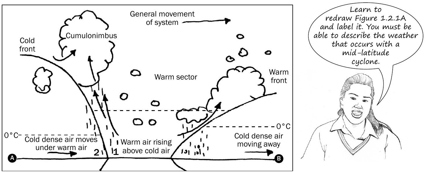
The diagram above shows how cold, dense air moves underneath warmer air because cold air is heavier. This creates the characteristic wedge shape of the cold front. As the warm air is forced upward, it cools and forms different types of clouds, leading to various weather conditions.
The 0°C line shown in the diagram indicates where temperatures change from above to below freezing, which affects the type of precipitation that occurs.
Movement patterns
Mid-latitude cyclones generally move from west to east across South Africa. This means that when meteorologists track these systems, they can predict which areas will experience the cold front first and which will be affected later.
The predictable west-to-east movement pattern is crucial for weather forecasting in South Africa. This allows meteorologists to issue warnings and help communities prepare for changing conditions as the system approaches.
As the system moves eastward, different locations experience the weather conditions in a predictable sequence - first the conditions ahead of the cold front, then the cold front itself, and finally the conditions behind the front.
Weather conditions with cold fronts
The weather conditions associated with mid-latitude cyclones change dramatically as the cold front passes through an area. Understanding these changes helps explain why the weather can shift so quickly during these events.
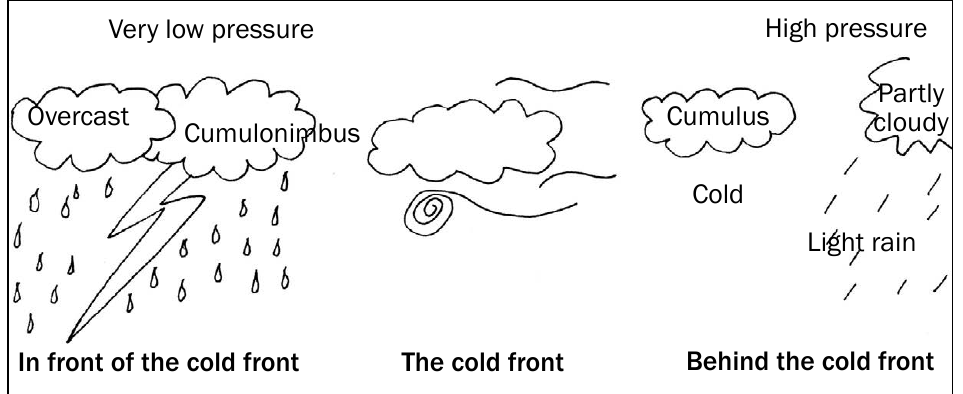
Weather in front of the cold front
Before the cold front arrives, several distinctive weather conditions develop:
The temperature remains relatively cool, and atmospheric pressure drops to very low levels. This low pressure creates unstable conditions in the atmosphere. Cloud cover becomes overcast with thick, heavy clouds dominating the sky. The most dramatic feature is the development of cumulonimbus clouds, which are the towering storm clouds responsible for producing thunderstorms. These conditions often bring heavy rainfall and can produce spectacular lightning displays and thunder.
Weather Sequence - Before Cold Front:
Step 1: Atmospheric pressure drops significantly
Step 2: Thick, overcast clouds develop
Step 3: Cumulonimbus clouds form
Step 4: Heavy rain and thunderstorms occur
Weather behind the cold front
After the cold front passes, the weather conditions change significantly:
Temperatures drop noticeably as the cold air mass takes control of the area. Atmospheric pressure rises sharply, creating more stable conditions. The heavy overcast conditions clear, replaced by partly cloudy skies with cumulus clouds. These are the smaller, white, fluffy clouds often seen on pleasant days. Precipitation changes from heavy rain to light rain or stops altogether.
Weather Sequence - After Cold Front:
Step 1: Temperature drops significantly
Step 2: Atmospheric pressure rises
Step 3: Overcast conditions clear
Step 4: Partly cloudy skies with cumulus clouds develop
Step 5: Rain decreases or stops
The most dramatic weather changes occur during the passage of the cold front itself. This is when temperatures drop most rapidly and weather conditions shift from stormy to clear.
Satellite identification
Modern weather forecasting relies heavily on satellite imagery to track and identify mid-latitude cyclones as they approach and move across the continent.
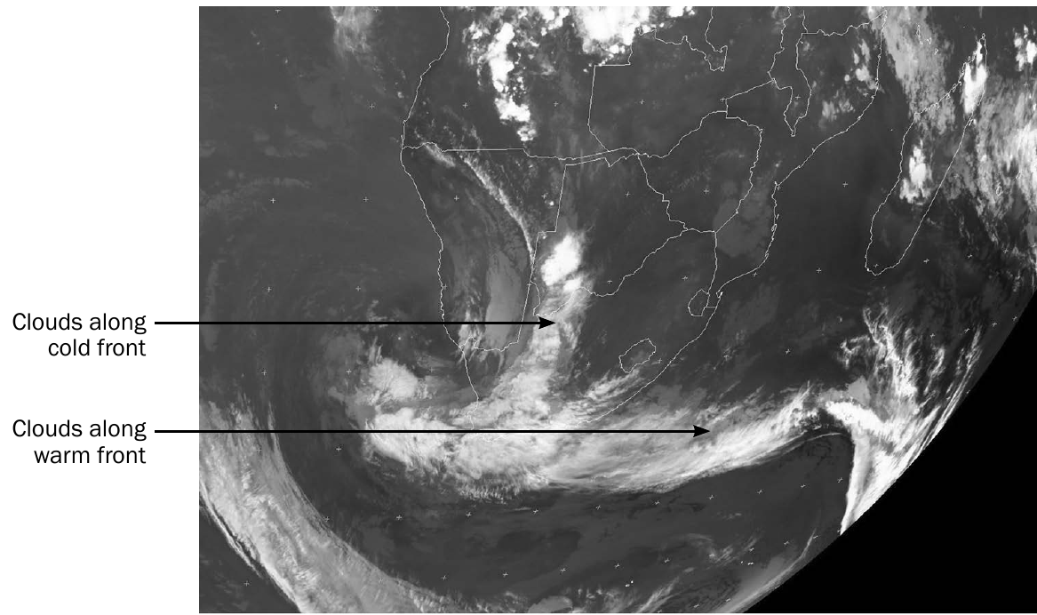
Satellite images show the characteristic cloud patterns associated with both cold and warm fronts. The cold front appears as a more defined, linear band of clouds, while the warm front shows as a broader, more diffuse area of clouds. These distinctive patterns help meteorologists track the movement and intensity of the weather system.
Importance for South Africa
Mid-latitude cyclones are crucial for South African weather patterns and are frequently tested in NSC examinations. Most of South Africa's significant weather changes are caused by the passage of cold fronts associated with these cyclone systems.
Understanding these weather systems helps explain:
- Why temperatures can drop suddenly
- Why heavy rains are often followed by clearer skies
- Why weather conditions change from west to east across the country
- How meteorologists make weather predictions
Key Points to Remember:
- Mid-latitude cyclones bring the most significant weather changes to South Africa through their cold fronts
- These systems move from west to east, allowing weather prediction as they approach
- Cold fronts create a sequence of weather conditions: stormy weather in front, then clearing and cooler conditions behind
- The cold, dense air slides under warm air, forcing it upward and creating different cloud types and weather patterns
- Satellite images help identify these systems by their characteristic cloud formations along the fronts