Magnetic Declination (Grade 12 NSC Matric Geography): Revision Notes
Magnetic Declination
Understanding magnetic declination
Magnetic declination represents the angular difference between true north and magnetic north at any given location. This concept is crucial for accurate navigation and mapwork because compass needles point to magnetic north, not true north.
The position of magnetic north shifts over time due to changes in Earth's magnetic field. This means the angle between true north and magnetic north (the magnetic declination) also changes annually.
When working with maps, you need to calculate what the magnetic declination is for the current year, not just use the value that was recorded when the map was created.
Key components and terminology
Understanding these fundamental elements is essential for magnetic declination calculations:
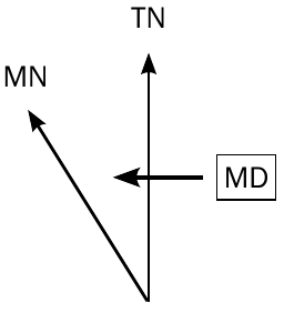
True North (TN) - This points directly towards the North Pole and remains constant. It serves as your fixed reference point for all calculations.
Magnetic North (MN) - This indicates the direction a compass needle points. Unlike true north, this direction changes over time due to shifts in Earth's magnetic field.
Magnetic Declination (MD) - This is the angle you're calculating. It represents the angular separation between true north and magnetic north.
Annual Change (AC) - This shows how much the magnetic declination shifts each year. The change can occur in either an eastward or westward direction, measured in minutes.
Maps typically display the magnetic declination information on the left side or bottom. This data includes the declination for the year the map was created and the annual rate of change.
Step-by-step calculation method
Follow this systematic approach to determine magnetic declination for any given year:
Step-by-Step Calculation Process
Step 1: Calculate the time difference Work out how many years have passed between the current year and the year shown on the map. Use only the year that appears after "true north" on the map - you can ignore any month information that might be included.
Step 2: Determine total change Multiply the number of years (from Step 1) by the mean annual change given on the map. This calculation gives you the total change in magnetic declination since the map was created.
Step 3: Apply the directional rule This step depends on the direction of the annual change:
- If the annual change is eastwards: subtract the total change from the original magnetic declination
- If the annual change is westwards: add the total change to the original magnetic declination
Step 4: Express your final answer Present your result as the magnetic declination for the current year.
Critical Directional Rule:
- Eastward annual change = SUBTRACT from original declination
- Westward annual change = ADD to original declination
Remember that magnetic declination is always expressed as "west of true north" in your final answer.
Worked examples
Example 1: Westward annual change
Worked Example: Westward Annual Change
Starting information:
- Mean magnetic declination: west of true north (1990.01)
- Mean annual change: westwards (1985-1995)
- Target year: 2012
Calculation process:
- Years difference: years
- Total change:
- Since change is westward: west of TN
Final Answer: 20° 54' west of true north
Example 2: Eastward annual change
Worked Example: Eastward Annual Change
Starting information:
- Mean magnetic declination: west of true north (1985.01)
- Mean annual change: eastwards (1980-1990)
- Target year: 2012
Calculation process:
- Years difference: years
- Total change:
- Since change is eastward: west of TN
Final Answer: 18° 23' west of true north
Handling special cases
Converting decimal degrees to minutes
When magnetic declination appears as a decimal (like ), convert the decimal portion to minutes by multiplying by 6. For instance, , so becomes .
Managing answers with minutes exceeding 59'
Converting Minutes to Degrees
After completing your calculation, if the minutes exceed 59', convert them to degrees. Subtract 60 from the minutes and add 1 to the degrees.
For example, if you get , this becomes of TN.
Complex scenarios with borrowing
Sometimes when subtracting for eastward changes, you may need to "borrow" from the degrees. If you need to subtract a larger number of minutes than available, borrow (which equals ) from the degrees column and add it to the minutes before subtracting.
Common mistakes to avoid
Critical Mistakes Students Make:
- Forgetting to apply the correct directional rule (adding when they should subtract, or vice versa)
- Using the wrong year as the starting point (remember to use the year after "true north")
- Incorrectly converting between degrees and minutes
- Not expressing the final answer as "west of true north"
Remember the logic: Eastward annual change means the declination is getting smaller (subtract), while westward annual change means it's getting larger (add).
Always double-check your directional logic and mathematical conversions before finalising your answer.
Key takeaways
Key Points to Remember:
- Magnetic declination is the angle between true north and magnetic north that changes over time
- Eastward annual change means subtract the total change from the original declination
- Westward annual change means add the total change to the original declination
- Always convert minutes greater than into additional degrees ()
- Final answers should always be expressed as "west of true north"