Position / Co-ordinates (Grade 12 NSC Matric Geography): Revision Notes
Position / Co-ordinates
Understanding how to find and write the exact position of any point on Earth is a fundamental mapwork skill. Co-ordinates help us locate specific places with pinpoint accuracy, making them essential for navigation, surveying, and geographical analysis.
What are co-ordinates?
Co-ordinates are a set of two numbers that tell us exactly where a place or landmark is located on Earth's surface. Think of them as a precise address system for any point on our planet.
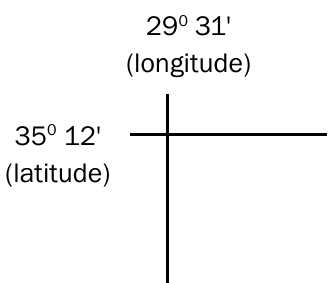
Latitude is the measurement that tells us how far north or south a point is from the equator. It specifies the north-south position of a point on Earth's surface.
Longitude is the measurement that tells us how far east or west a point is from the Prime Meridian (0° longitude). It specifies the east-west position of a point on Earth's surface.
Co-ordinates are incredibly useful because they allow us to pinpoint exactly where a place or landform is located.
For example, if you only had the co-ordinates 35°S 29°E, you would need to search an area of approximately 6,084 km² to find a specific house - this shows why we need more precise measurements!
Understanding the correct format for writing position
When writing co-ordinates, there is a specific format that must always be followed. This standardised approach ensures everyone understands the location being described.
The correct format for writing position follows this pattern:
- ____° ,' S
- ____° ,' E
Key rules to remember:
- Latitude is always written first - this means the North/South measurement comes before the East/West measurement
- Latitude uses either N (North) or S (South)
- Longitude uses either E (East) or W (West)
- Both latitude and longitude are measured in degrees (°) and minutes (')
Understanding the grid system
On topographical maps, you'll notice several important features that help with accurate coordinate reading:
Grid System Features:
- Each line drawn on a map represents 1' (one minute) of latitude or longitude
- Every fifth minute line is labelled to help you count accurately
- Latitude minutes increase as you move south (down the map)
- Longitude minutes increase as you move east (to your right along the map)
Step-by-step method for finding the position of an object
Finding the exact position of a point on a map requires careful measurement and calculation. Here's the systematic approach used for determining co-ordinates:
Worked Example: Finding Position Coordinates
Step 1: Set up your format Write the position format leaving blanks for your measurements:
- ____° ,' S
- ____° ,' E
Step 2: Find the degrees Look at the top left-hand corner of your map to find the degree values for latitude and longitude. Write these degrees in your format:
- 24° ,' S
- 31° ,' E
Step 3: Identify the minute blocks Determine which minute blocks contain your point. The point will be located between specific minute lines. For example:
- 24° 10',____' S
- 31° 28',____' E
Detailed measurement process
The precision measurement involves several key steps that require careful attention to detail:
Step 4: Measure latitude position Measure the distance between the two latitude lines (e.g., between 10' and 11') and divide this measurement by 2. Mark where your measurement of 3 cm falls on this line.
Step 5: Measure longitude position Measure the distance between the two longitude lines (e.g., between 28' and 29') and divide this measurement by 2. Mark where your measurement of 4.7 cm falls on this line.
Step 6: Divide into decimal places The space between minute lines is divided into 10 decimal places. This means the area is subdivided into: 10.1', 10.2', 10.3', 10.4', 10.5', 10.6', 10.7', 10.8', 10.9'.
Since the point is in the bottom half of the latitude block, focus on the 10.5' to 10.9' section. Divide this half section equally into 4 lines to help with precise measurement.
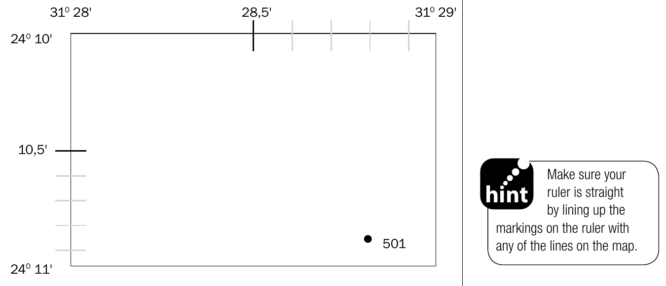
Step 7: Apply the same process to longitude The space between 28' and 29' longitude is also divided into 10 decimal places: 28.1', 28.2', 28.3', 28.4', 28.5', 28.6', 28.7', 28.8', 28.9'.
Since the point is in the right-hand half of the longitude block, focus on the 28.5' to 28.9' section and divide this half equally with 4 lines.
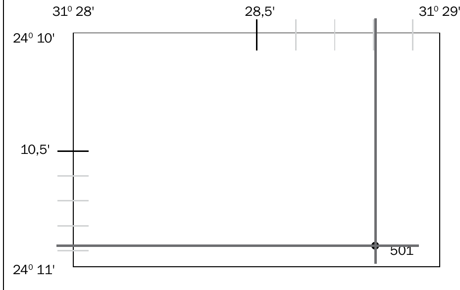
Step 8: Read the latitude measurement Line up your ruler with the point and the latitude line (on the left of the map). Make a mark and read off the decimal place for latitude. Write this in your format:
- 24° 10.8' S or 24° 10.9' S (both answers are acceptable)
Step 9: Read the longitude measurement Line up your ruler with the point and the longitude line (at the top of the map). Make a mark and read off the decimal place for longitude. Write this in your format:
- 31° 28.8' E
Final Answer: 24° 10.8' S; 31° 28.8' E
Important exam tip In NSC examinations, position questions often appear in multiple-choice sections. Be careful - some incorrect options may show longitude written first instead of latitude. Remember that latitude is always written first.
Map sheet references/map code
The map sheet reference system is used to identify and link different sections of South African topographical maps. Understanding this system helps you navigate between different map sheets and locate specific areas.
What is a map sheet reference?
A map sheet reference is the title of a map that refers to the specific area the map covers. This reference system links one South African map to all other maps of South Africa, creating a comprehensive grid system.
Understanding the numbering system
A typical map sheet reference looks like 3318CD. Each part has specific meaning and follows a logical pattern:
Map Reference Breakdown:
- The numbers (3318) refer to the intersection of lines of latitude and longitude
- The first two numbers (33) refer to latitude
- The last two numbers (18) refer to longitude
- The letters (CD) refer to the specific blocks within that grid section
Grid subdivision system
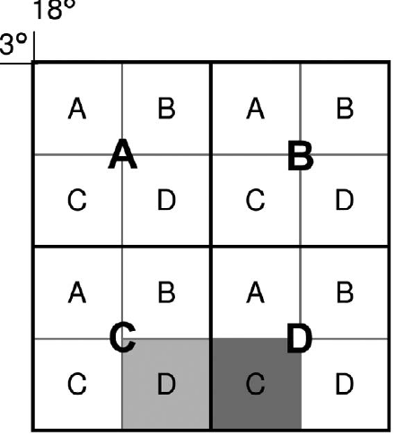
The area within the latitude and longitude lines is divided systematically using a hierarchical approach:
Subdivision Process:
- Big blocks: The main area is divided into four large squares, labelled A, B, C, and D
- Small blocks: Each big block is then subdivided into four smaller squares, also labelled A, B, C, and D
Typical exam questions
You may encounter two types of questions about map sheet references that test different skills:
Question Types:
-
Direct identification: "What is the map sheet reference of the map?"
- The answer will be found at the top of the map, usually in front of the place name
-
Directional reference: "Name the map sheet reference in any direction from the given map sheet reference"
- This requires understanding the grid system and how adjacent maps are coded
Practical example: For a map titled 3318CD Cape Town:
- If asked for the map sheet reference to the east of 3318CD
- The block to the east would have a different letter designation
- You need to understand how the A, B, C, D system works in relation to compass directions
Key Points to Remember:
- Co-ordinates consist of latitude (north-south) and longitude (east-west) measurements
- Always write latitude first, followed by longitude
- Use the step-by-step method to measure positions accurately
- Divide grid sections into decimal places for precise measurements
- Map sheet references use a systematic numbering and lettering system to identify specific areas