Scale (Grade 12 NSC Matric Mathematical Literacy): Revision Notes
Scale
Scale is a crucial concept in maps and plans that shows the relationship between distances on a drawing and actual distances in real life. There are two main types of scales you need to understand: the number scale and the bar scale.
Understanding scale is essential for reading maps, architectural plans, and technical drawings accurately. Scale allows us to represent large real-world distances on manageable paper sizes while maintaining accurate proportional relationships.
The number scale
The number scale is expressed as a ratio, such as 1:50 or 1:500. This means that 1 unit on the map represents a specific number of units on the ground in real life.
For example, if a map has a scale of 1:50:
- 1 cm on the map represents 50 cm on the ground
- 1 m on the map represents 50 m on the ground
The key to using number scales successfully is understanding unit conversions. You must always ensure both measurements are in the same units before calculating.

Critical Rule: Both values must be written in the same units! Always convert measurements to matching units before performing any scale calculations.
How to use the number scale
To calculate real distances using a number scale:
- Measure the distance on the map using your ruler
- Multiply that measurement by the "real" part of the scale ratio
- Convert units if necessary to get your final answer
Worked Example: Number Scale Calculations
Problem a) You measure 10 cm between two buildings on a map with scale 1:40. What is the actual distance in metres?
Solution:
- Scale is 1:40
- Map distance = 10 cm
- Real distance = 10 cm × 40 = 400 cm = 4 m
Problem b) On a map with scale 1:50,000, you measure 15 cm. What is the actual distance in km?
Solution:
- Scale is 1:50,000
- Real distance = 15 cm × 50,000 = 750,000 cm = 7.5 km
The bar scale
The bar scale is represented as a visual measurement tool that looks like a ruler or bar with marked segments. Each segment represents a specific distance on the ground.
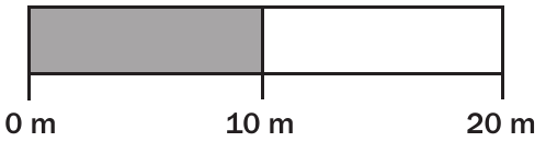
The bar scale provides a visual reference that makes it easier to estimate distances quickly. Unlike number scales, bar scales remain accurate even when maps are photocopied or resized.
The bar scale shows segments with labels underneath indicating the real-world distances they represent. To use a bar scale:
- Measure how long one segment of the bar is on your ruler
- Measure the distance on the map in centimetres
- Calculate how many segments fit into your measured distance
- Multiply by the scale value underneath to get the real distance
How to calculate using bar scales
If 1 cm on the bar represents 10 m on the ground, and you measure 3 cm on the map:
- 3 cm ÷ 1 cm per segment = 3 segments
- 3 segments × 10 m = 30 m real distance
Worked Example: Bar Scale Calculations
Problem a) You measure 10 cm on a map with a bar scale where 1 cm = 15 m. What is the actual distance?
Solution:
- 1 segment = 1 cm on ruler = 15 m on ground
- 10 cm = 10 × 15 m = 150 m on the ground
Problem b) You measure 11 cm on a map where 2 cm on the bar scale = 100 m. What is the actual distance?
Solution:
- 1 segment = 2 cm on ruler = 100 m on ground
- 11 cm ÷ 2 cm per segment = 5.5 segments
- 5.5 segments × 100 m = 550 m on the ground
Understanding advantages and disadvantages of number and bar scales
Both types of scales have important advantages and disadvantages, especially when maps are resized or photocopied.
Advantages of number scales:
- Simple calculations - you only measure one distance
- Don't need to measure segment lengths
- Calculations are usually straightforward
Disadvantages of number scales:
- When maps are resized, the number scale becomes incorrect
- You must know that the scale has changed with the map size
- Critical to check conversions carefully
Advantages of bar scales:
- When resizing a map, the bar scale resizes with it and remains accurate
- Visual representation makes it easier to estimate distances quickly
- More reliable for photocopied or printed maps
Disadvantages of bar scales:
- Must measure the length of one segment first
- Calculations can be more complicated
- Need to calculate how many segments fit into your measured distance
Key Insight: When working with photocopied or resized maps, always use bar scales for accurate measurements. Number scales become unreliable when the map size changes.
Drawing a scaled map when given real dimensions
Sometimes you need to work backwards - taking real measurements and creating a scaled drawing. This requires converting actual dimensions to scaled measurements.
To draw a scaled map:
- Know the actual measurements of everything to include
- Choose an appropriate scale for your drawing size
- Convert each real measurement to the scaled measurement by dividing by the scale factor
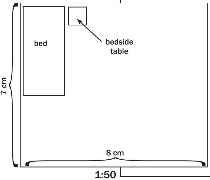
Worked Example: Drawing a Scaled Bedroom Plan
Problem: Draw a floor plan of a bedroom that is 3.5 m by 4 m, with a bed (92 cm × 188 cm) and bedside table (400 mm square). Use scale 1:50.
Solution: Scale 1:50 means 1 unit on drawing = 50 units in real life.
Room dimensions:
- Width: 3.5 m = 350 cm ÷ 50 = 7 cm on drawing
- Length: 4 m = 400 cm ÷ 50 = 8 cm on drawing
Furniture dimensions:
- Bed: 188 cm × 92 cm ÷ 50 = 3.76 cm × 1.84 cm on drawing
- Bedside table: 400 mm = 40 cm ÷ 50 = 0.8 cm × 0.8 cm on drawing
Key conversion steps
When drawing scaled plans, remember these conversion steps:
| Real life measurement | Calculation | Measurement on plan |
|---|---|---|
| 5 metres | 5 m = 500 cm ÷ 50 = 10 cm | 10 cm |
| 810 mm | 810 mm ÷ 50 = 16.2 mm = 1.62 cm | 1.62 cm |
| 1000 mm | 1000 mm ÷ 50 = 20 mm = 2 cm | 2 cm |
Key Points to Remember:
- Always convert all measurements to the same units before calculating
- For drawing scaled plans, divide real measurements by the scale factor
- For finding real distances from scaled drawings, multiply by the scale factor
- Bar scales remain accurate when maps are resized, but number scales do not
- Double-check your unit conversions - this is where most mistakes occur
- Choose appropriate scales for your drawing size and level of detail needed