World Time Zones (Grade 12 NSC Matric Tourism): Revision Notes
World Time Zones
What are time zones?
A time zone represents one of 24 longitudinal divisions across Earth's surface where people use the same standard time. The world is divided into these zones to help coordinate time globally, with each zone covering approximately 15 degrees of longitude. This system ensures that when the sun is directly overhead in any location, the local time shows around midday.
The time zone system was developed to create order from the chaos that existed when every town and city kept its own local time based on the sun's position. Before standardisation, train schedules and communication were extremely difficult to coordinate across distances.
The primary division runs through Greenwich, England, which serves as the global reference point. Each time zone experiences a clock time that differs by one hour from the zone immediately next to it - earlier to the west and later to the east.
Key concepts and terminology
UTC (Universal Time Coordinate)
UTC serves as the primary global time standard that regulates clocks and time worldwide. Think of UTC as the "master clock" that all other time zones reference. It replaced Greenwich Mean Time (GMT) as the international standard, though both terms are often used interchangeably in everyday conversation.
While GMT and UTC are often used interchangeably in daily conversation, UTC is technically more precise as it's based on atomic time rather than astronomical observations. For most practical purposes, however, they represent the same time.
Greenwich and the prime meridian
The 0° line of longitude passes through Greenwich in London, England. This imaginary line, known as the prime meridian, divides Earth into Western and Eastern Hemispheres. Greenwich was chosen as the global starting point for measuring time zones, making it the reference point from which all other times are calculated.
Hemispheres
Earth is divided into four hemispheres:
- Northern and Southern Hemispheres (separated by the equator)
- Eastern and Western Hemispheres (separated by the Greenwich Meridian)
Understanding hemispheres helps explain why different parts of the world experience different seasons and daylight hours simultaneously.
Standard time vs local time
Standard time refers to the official time used throughout an entire country, calculated from Greenwich. For example, South Africa uses South African Standard Time (SAST), which is UTC+2.
Local time represents the specific time that everyone in a particular area agrees to use. In most cases, local time matches the country's standard time, but some regions may observe different practices.
International Date Line (IDL)
The International Date Line is an imaginary line located at 180° longitude - directly opposite Greenwich on the other side of Earth. When you cross this line:
- Travelling westward: you move forwards one day
- Travelling eastward: you move backwards one day
The International Date Line doesn't follow 180° longitude exactly - it zigzags around countries and territories to avoid splitting them into different days. This means some island nations that would otherwise be split can maintain the same date throughout their territory.
This line prevents confusion about dates when travelling across the Pacific Ocean.
The 24-hour clock system
The 24-hour clock runs from midnight to midnight, with hours numbered from 0 to 23. This system eliminates confusion between morning and evening hours:
- 0:00 = midnight
- 12:00 = midday
- 23:59 = one minute before midnight
This format is commonly used in international travel, military contexts, and many countries worldwide.
Geographic coordinates and time zones
Latitude and longitude form a coordinate system that pinpoints any location on Earth. Longitude lines (running north-south) are particularly important for time zones because:
- They lie east and west of the Greenwich Meridian
- They divide the world into 24 time zones
- Each 15° of longitude represents one hour of time difference
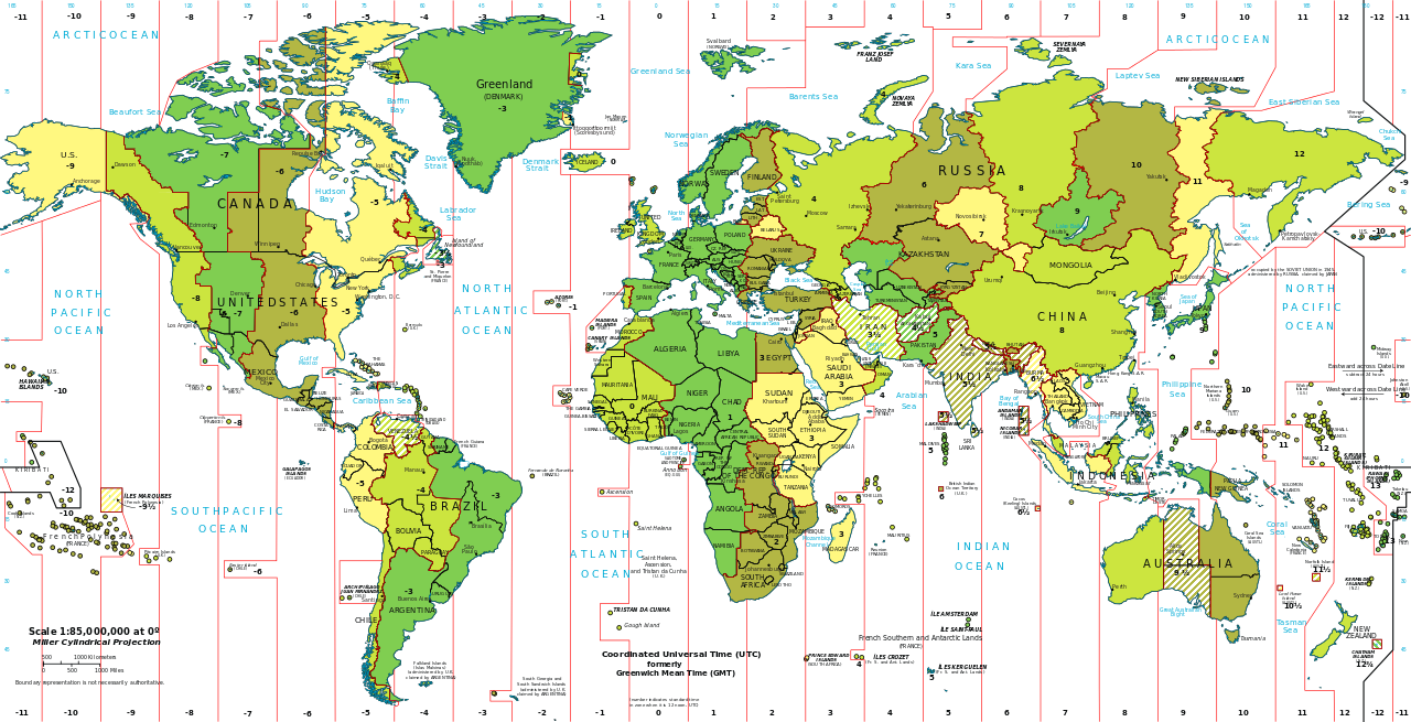
Understanding world time zone maps
Time zone maps are essential tools for understanding global time differences, but they can initially seem complex due to irregular boundaries and multiple pieces of information displayed simultaneously.
Time zone maps display the different time zones around the world using colours and numbers. These maps show:
- Time differences from UTC (marked as +/- hours)
- Major cities and their local times
- International boundaries and how they affect time zones
- Irregular time zone boundaries due to political and geographical factors
When reading these maps, remember that countries may choose time zones that best suit their needs rather than strictly following longitudinal lines.
Daylight saving time (DST)
Daylight Saving Time adds complexity to time zone calculations because different countries implement it at different times of the year, and some countries don't observe it at all. Always verify DST status when planning international activities.
Daylight Saving Time involves adjusting clocks to make better use of daylight during different seasons. During DST:
- Clocks move forwards one hour in spring/summer ("spring forwards")
- Clocks move back one hour in autumn/winter ("fall back")
- Not all countries observe DST
Reasons for implementing DST
Countries implement DST for several practical reasons:
- Extended evening daylight: People can enjoy more daylight hours after work for outdoor activities
- Road safety: Improved visibility during evening commute times may reduce traffic accidents
- Social benefits: Children have more daylight hours for outdoor play and social activities
- Tourism boost: Extended evening daylight encourages outdoor recreational activities
- Energy conservation: Reduced need for artificial lighting during extended daylight hours
Impact on travel planning
Understanding time zones and DST becomes crucial when planning international travel. The complexity increases significantly when crossing multiple time zones or travelling during DST transition periods.
Flight scheduling considerations
Flight times are typically displayed in local time for both departure and arrival locations. This means a 3-hour flight eastward might show as departing at 2:00 PM and arriving at 6:00 PM due to time zone changes, even though the actual flight duration is only 3 hours.
- Eastward travel: You lose an hour for each time zone crossed, making flights appear longer
- Westward travel: You gain an hour for each time zone crossed, making flights appear shorter
- Long-haul flights: May arrive the next day (eastward) or same day (westward) due to time differences
Essential travel knowledge
Travellers must understand:
- Whether their destination observes DST and when changes occur
- How crossing the International Date Line affects dates
- Local time differences for scheduling connections, accommodation check-ins, and activities
- How jet lag increases with greater time zone differences
Practical planning tips
Pro Travel Tips:
- Always confirm time zones when booking hotels or tours online
- Set your phone to display multiple time zones when travelling
- Consider arriving a day early for important meetings when crossing many time zones
- Check if your destination observes DST during your travel period
- Check time zone differences before booking connecting flights
- Verify whether destinations observe DST during your travel dates
- Plan arrival times considering local customs and business hours
- Allow extra time for connections when crossing multiple time zones
Key Points to Remember:
- Earth has 24 time zones, each covering approximately 15 degrees of longitude, with one-hour differences between adjacent zones
- Greenwich, England (0° longitude) serves as the global reference point for calculating all time zones worldwide
- UTC (Universal Time Coordinate) is the international standard that replaced GMT as the master time reference
- The International Date Line at 180° longitude is where the date changes - crossing it means gaining or losing a full day
- Daylight Saving Time helps maximise daylight usage but creates additional complexity for travellers who must track when different countries implement these changes