Choosing Your Topic and Using GIS (AQA A-Level Geography): Revision Notes
Choosing Your Topic and Using GIS
Understanding the fieldwork investigation pathway
Your A-Level geography fieldwork follows a structured approach that takes you from initial ideas through to final evaluation. This pathway ensures your investigation is thorough, well-organised, and meets the requirements of the AQA specification.
The process involves six key stages that build upon each other. Each stage is important, and together they form a complete investigation. Throughout the entire process, you must maintain a high quality of written argument that clearly explains your thinking and justifies your decisions.
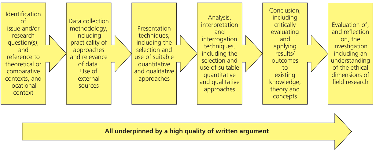
The fieldwork pathway is sequential - each stage builds on the previous one. Think of it as a journey from your initial research question through to reflecting on your completed investigation. Quality written argument underpins every single stage.
The six stages explained
Stage 1: Identification
You begin by identifying your research question(s) and providing context. This means explaining what you want to investigate and why it matters. You should connect your work to geographical theory and existing knowledge. Consider how your study relates to broader concepts and what other researchers have found about similar topics.
Stage 2: Data collection
This stage focuses on your methodology - how you will gather information. You need to think carefully about what approaches you will use and ensure they are practical and appropriate. Your data collection should include both primary data (information you collect yourself in the field) and secondary data (existing information from external sources like maps, census data, or previous studies).
Stage 3: Presentation
Once you have collected your data, you need to present it clearly. Choose appropriate techniques based on whether your data is quantitative (numerical) or qualitative (descriptive). Different types of data require different presentation methods, such as graphs, maps, photos, or written descriptions.
Stage 4: Analysis and interpretation
This is where you make sense of your data. Use suitable quantitative techniques (like statistical tests) and qualitative approaches (like identifying themes or patterns) to interpret what your findings mean. Your analysis should be thorough and appropriate for the type of data you have collected.
Worked Example: Linking Analysis to Data Type
If you collected numerical data on pedestrian counts in a town centre:
- Quantitative analysis: Calculate mean values, create graphs showing temporal patterns, use statistical tests to compare locations
- Qualitative analysis: Describe observed patterns, explain why certain areas were busier, link findings to urban geography theory
If you collected interview responses about coastal management:
- Qualitative analysis: Identify common themes, categorise opinions, quote significant responses
- Quantitative analysis: Count frequency of different viewpoints, create charts showing percentage breakdowns
Stage 5: Conclusions and critical evaluation
You must draw conclusions that relate directly back to your original aims and research questions. Critically evaluate your findings by applying them to existing knowledge, theory and concepts. This means discussing how your results compare with what others have found and what geographical theory would predict.
Stage 6: Evaluation and reflection
The final stage involves reflecting on your entire investigation. Consider the ethical dimensions of your field research - did you treat people and places respectfully? Think about what went well, what could be improved, and how the investigation could be developed further if you had more time or resources.
Choosing an appropriate fieldwork topic
Selecting the right topic for your fieldwork is crucial to your success. Your topic must be carefully considered because you will spend significant time working on this investigation. The topic needs to be manageable yet substantial enough to allow detailed analysis.
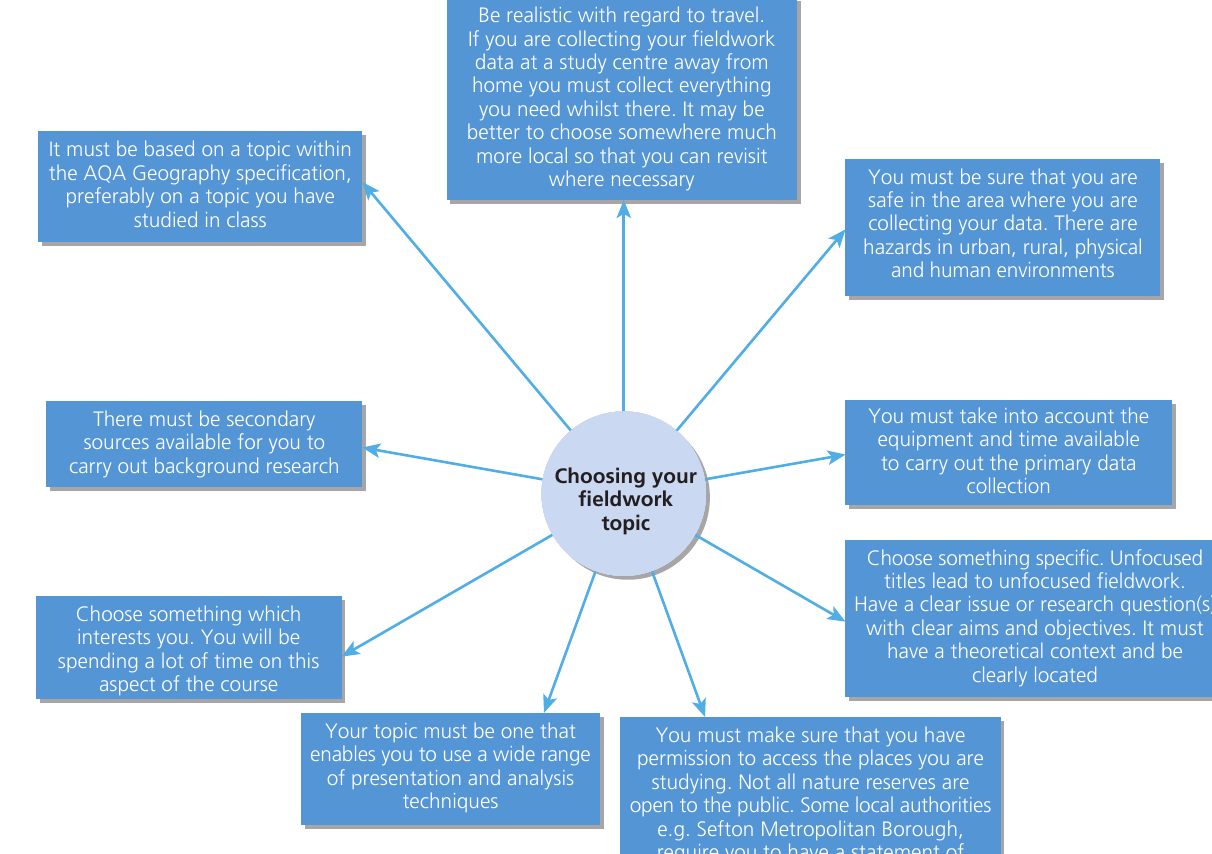
Key considerations when selecting your topic
Alignment with the specification
Your topic must be based on something within the AQA Geography specification. Ideally, choose a topic you have already studied in class as this gives you essential background knowledge. You cannot investigate something completely new that is not covered in your course. This connection ensures you can link your fieldwork to geographical theory and concepts.
Travel and accessibility
Be realistic about travel requirements. If your chosen fieldwork location is far from home or school, you must collect everything you need in one visit. It may be better to choose somewhere more local so you can revisit if necessary. Consider transport costs, time, and whether you can easily return if you need additional data.
Practical Tip: Local fieldwork sites offer flexibility. If you discover you need additional measurements or realize you've missed something important, you can easily return for a second visit. This isn't possible with distant locations that require special travel arrangements.
Health and safety
Your safety is paramount. You must be confident that you are safe in your chosen study area. Different environments present different hazards:
- Urban areas: traffic, strangers, busy locations
- Rural areas: isolation, weather exposure, difficult terrain
- Physical environments: water hazards, cliffs, unstable ground
- Human environments: busy roads, unfamiliar areas
Always carry out a risk assessment and follow safety guidelines.
Safety First: Never compromise on safety for the sake of your investigation. If a location seems risky or makes you uncomfortable, choose somewhere else. Your teacher must approve all fieldwork locations, and you should always follow their guidance on risk assessments and safety procedures.
Equipment and time
Think practically about what equipment you need and how long data collection will take. Do you have access to the necessary tools? Can you realistically collect all the data you need in the time available? Consider whether you need specialist equipment that might be difficult to obtain or use.
Permission and access
Before starting, ensure you have permission to access your study locations. Not all nature reserves are open to the public - some require special permission. Certain local authorities, such as Sefton Metropolitan Borough, require you to have public liability insurance before conducting studies on coastal dunes. Check access requirements well in advance.
Access Planning: Start researching access requirements early in your planning process. Some permissions can take weeks to obtain, and you don't want delays to affect your data collection schedule. Keep records of all permissions granted - you may need to reference these in your report.
Secondary data availability
There must be secondary sources available for background research. These might include:
- Census data
- Historical maps
- Previous studies of the area
- Climate records
- Land use surveys
- Government reports
Secondary data provides context and allows you to compare your findings with existing information.
Personal interest and commitment
Choose something that genuinely interests you. You will spend considerable time on this investigation, so select a topic that motivates you. Your enthusiasm will show in the quality of your work and will help you stay focused when the investigation becomes challenging.
Specificity and focus
Avoid unfocused titles that lead to vague investigations. You need a clear issue or research question with clear aims and objectives. Your study must have a theoretical context (connecting to geographical concepts) and be clearly located (specific place and time). A well-defined focus makes data collection and analysis much easier.
Use of diverse techniques
Your topic should enable you to use a wide range of presentation and analysis techniques. This demonstrates your geographical skills and allows you to explore the data from different perspectives. Consider whether your chosen topic will generate both quantitative and qualitative data.
Report Requirements: After completing your fieldwork, you are required to write and submit a report of 3,000-4,000 words based on one or more aspects of your investigation. This will be marked by your teachers and moderated by AQA. The topic you choose must be linked to an area of the AQA A-Level specification.
Using geographical information systems in fieldwork
Geographical Information Systems (GIS) are powerful digital tools that can significantly enhance your fieldwork investigation. They bring together mapping technology and data analysis in ways that would be difficult or impossible to achieve manually.
What is GIS?
GIS Definition
Geographical information systems have the ability to store, retrieve, manipulate and analyse a range of spatially related data. With a GIS, you can ask questions of data related to a map, search for patterns and distributions, and investigate the underlying relationships between different sets of data.
Think of GIS as a way of layering different types of geographical information on top of each other. For example, you could combine a map showing land use with data about population density, environmental quality scores, and your fieldwork photographs - all linked to specific locations.
How GIS enhances fieldwork investigations
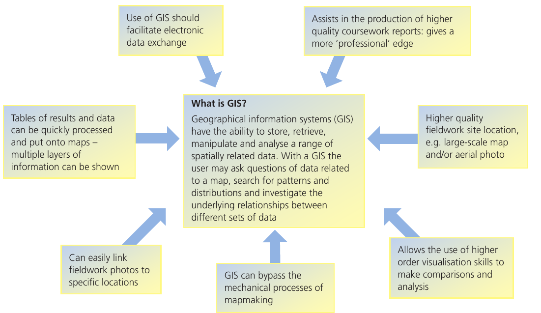
Electronic data exchange
GIS facilitates easy electronic data exchange, making it simple to share your findings or incorporate data from other sources. You can export your maps and analysis in various formats and integrate data from multiple sources into one system.
Data Integration: One of GIS's greatest strengths is bringing together data from different sources. You might combine your own field measurements with government census data, historical maps, and satellite imagery - all precisely aligned to the same geographical coordinates.
Higher quality coursework reports
Using GIS assists in producing higher quality coursework reports. Your work will have a more professional edge with clear, accurate maps and sophisticated data visualisation. This can make complex geographical patterns much clearer to your readers.
Superior site location and mapping
GIS provides higher quality fieldwork site location information. You can use large-scale maps and aerial photographs to show exactly where you collected data. This precision is important for explaining your methodology and for others who might want to replicate your study.
Enhanced data visualisation
GIS allows you to use higher order visualisation skills to make comparisons and conduct analysis. You can create multiple map layers, use different colours to show patterns, and generate graphs directly from your spatial data. This helps you spot relationships and trends that might not be obvious in tables of numbers.
Bypassing manual mapmaking
Traditional mapmaking is time-consuming and requires considerable skill. GIS can bypass these mechanical processes of mapmaking, allowing you to focus on analysis rather than drawing. The software handles the technical aspects of map production automatically.
Linking photos to locations
You can easily link your fieldwork photos to specific locations on your map. This creates a clear visual record of conditions at each sampling point. Clicking on a location can display the photograph you took there, providing valuable context for your data.
Worked Example: Using Photo Links in GIS
Imagine you're investigating river channel characteristics along a 2km stretch:
- You take photos at 10 different points showing channel width, bed material, and vegetation
- In your GIS, each photo is linked to its exact GPS coordinates
- When you click on a point on your map, the corresponding photo appears
- This allows you to quickly compare visual conditions at different locations
- You can overlay this with graphs of quantitative measurements taken at the same points
Quick data processing
Tables of results and data can be quickly processed and fed into maps. The software can create multiple layers of information that can all be shown together. This speed allows you to test different ways of presenting your data and to update maps easily if you find errors or collect additional information.
Integration with GPS technology
Global Positioning Systems (GPS) technology works hand-in-hand with GIS. You can use GPS devices to record the exact position of data collection points along a transect or within a sampling system. The position of each point is recorded at the same time as you collect your data.
This GPS-located data can then be fed into your GIS program, bringing together data recording and mapping. This integration ensures accuracy and saves time because you do not need to manually plot points on a map later.
GPS-GIS Workflow: The typical workflow involves using a GPS-enabled device (smartphone, tablet, or dedicated GPS unit) to record your location as you collect data. Later, you import this data into your GIS software where it automatically appears in the correct locations on your map. This eliminates errors from manual plotting and ensures precise positioning.
Getting started with GIS
Many websites and programs are available for fieldwork use, including Multimap, Aegis, Digital Worlds, Quikmaps and Google Earth. Some allow you to use maps and photos together, while others let you add annotations. Different software requires different levels of training - some are straightforward to use whilst others need more advanced ICT skills. Choose software that matches your abilities and needs.
Key Points to Remember:
- Your fieldwork investigation follows six key stages: identification, data collection, presentation, analysis, conclusions, and evaluation - all require high quality written argument
- Choose a topic that links to the AQA specification, is safe and accessible, interests you personally, and allows you to use diverse geographical techniques
- Consider practical factors like travel, equipment, time, permissions, and availability of secondary data when selecting your topic
- GIS technology stores, retrieves, manipulates and analyses spatial data, helping you create professional reports with sophisticated visualisation
- GPS and GIS work together effectively - use GPS to record data locations in the field, then feed this into GIS programs for mapping and analysis