ICT Skills (AQA A-Level Geography): Revision Notes
ICT skills
Information and communication technology (ICT) plays a vital role in modern geographical research and analysis. Geographers can access vast amounts of data through electronic databases, innovative crowdsourcing platforms, and big data systems. Understanding how to use these tools effectively is essential for conducting meaningful geographical investigations.
Modern geography relies heavily on digital tools and data sources. Mastering these ICT skills will enable you to conduct more sophisticated and data-driven geographical investigations.
Use of electronic databases
Geographers have access to numerous electronic databases containing valuable geographical information. Many schools and colleges provide access to platforms like Digimap, which offers interactive mapping resources and Ordnance Survey data.
Key databases available to geographers:
-
ONS (Office for National Statistics) - Contains all government-collected information including census data, economic statistics, trade figures, and crime surveys
-
MetOffice UK - Holds weather records dating back to 1869, plus information on global climate patterns and climate change
-
Ordnance Survey - The UK's national mapping agency providing continuously updated databases with 450 million geographic features, from individual addresses to roads and railways. Uses TOID (unique reference codes) enabling layers to be combined with your own data
-
CIA World Factbook - Provides information on 267 countries covering history, people, government, economy, energy, geography, communications, transportation, military, and transnational issues
-
Planning Portal - Online resource for planning and building regulations in England and Wales, directing users to local planning information
-
Digimap - A collection of mapping services delivering data for Great Britain and UK tertiary education. Data can be downloaded for use with GIS or CAD software, or accessed through online map generation
Evaluating internet sources
When using the internet as a research tool, you must critically assess the reliability and validity of information.
Always ask these essential questions when evaluating online sources:
- Who published the information (organisation/agency/individual)?
- Who wrote the information (expert/interested individual)?
- What is the age of the material?
- Why does the material exist (academic research/special interest groups)?
- How one-sided (biased) are the arguments presented?
Remember the mnemonic WWAAH to help you evaluate sources effectively!
Not all online sources are equally reliable. Government and academic sources typically provide more trustworthy data than anonymous websites or those with commercial interests. Always cross-reference important information from multiple reputable sources.
Use of innovative sources of data such as crowdsourcing and 'big data'
Crowdsourcing
Traditional large-scale data collection methods like censuses and social surveys face significant limitations. They typically deal with broad population characteristics rather than individual behaviors, and they only provide snapshots rather than continuous information. However, new data sources available through social networks offer a wealth of detail about people's geographical behavior at the individual level.
Volunteered geographical information (VGI) refers to information with geographic footprints or associations contributed by users through platforms like social media, even when the original contributors did not intend it to be used for geographic purposes.
This represents a fundamental shift in how geographical data is collected - from top-down official surveys to bottom-up user-generated content.
These sources are commonly called geo-spatial crowdsourced data (GSD). This type of data is increasingly used to study individual daily behaviors and explore how these patterns might lead to civil unrest. GSD is also valuable for examining how people respond to natural disasters.
The early twenty-first century has witnessed numerous devastating natural disasters, including the Indian Ocean earthquake and tsunami (26 December 2004) and the Australian wildfires (2019/20). These events have highlighted the critical need for accurate maps and geospatial data on impacted areas, as well as the importance of geographically-distributed information-sharing communities in emergency response.
Social media platforms such as Twitter, Facebook, Flickr and YouTube contain large volumes of information with geographic associations that can be analyzed, even though contributors may not have intended the content to serve any specific geographic purpose.
Worked Example: Relief efforts after the Nepal earthquake (2015)
Following the devastating Nepalese earthquake on 25 April 2015, two critical questions needed immediate answers: Who needs help? And where? Relief organizations needed to deliver supplies and resources to the areas of greatest need, but lacked systematic data to guide deployment decisions. Even basic information like detailed road maps and locations of critical infrastructure was unavailable.
The Solution: Ushahidi Platform
Ushahidi, a crowdsourcing platform originally developed in Kenya to map post-election violence reports in Nairobi (2008), proved invaluable. As a social enterprise providing software and services to improve bottom-up information flow, Ushahidi helped Nepalese agencies understand what was happening on the ground as the disaster unfolded.
Results:
Organizations could immediately see who required what type of relief, and where:
-
Dobhan rescue: 18 trekkers became stranded between dangerous landslides near Dobhan. Using Ushahidi, they were evacuated within 48 hours, and food supplies were distributed to more than 60 others in the area.
-
Chayarsaba relief: A report highlighted urgent relief needs where roads were blocked or unstable and drinking water supplies had stopped because landslides damaged supply pipes. The Kathmandu Living Labs team used Ushahidi to verify reported needs and their exact locations. Roads were cleared, new water sources were secured and installed by the community, and multiple food drops were confirmed.
Limitations of crowdsourced data:
The massive volume of crowdsourced information available during disasters can create challenges:
- Aid organizations struggle to process and verify all reports, making accurate information difficult to extract
- Reports are often duplicated or contain inaccuracies, requiring careful verification before action can be taken
- The quality of data depends on users' willingness and ability to contribute
- Coverage may be uneven, with some areas better represented than others
Big data
Geographers have traditionally worked with large datasets, such as weather records and population census information. However, expensive and logistical constraints meant data could only be collected periodically and analyzed partially. Modern technology has transformed this landscape dramatically.
Big data refers to the enormous volumes of data held indefinitely in cloud-based servers, typically measured in terabytes or petabytes.
To put this in perspective, a single petabyte equals 1,000 terabytes or approximately 500 billion pages of standard text!
Until recently, analyzing such vast quantities of data was impractical. However, the development of geographical information systems (GIS) has provided tools enabling spatial data to be collected, stored, archived, managed, analyzed and presented effectively. Even these sophisticated systems have limitations in scope.
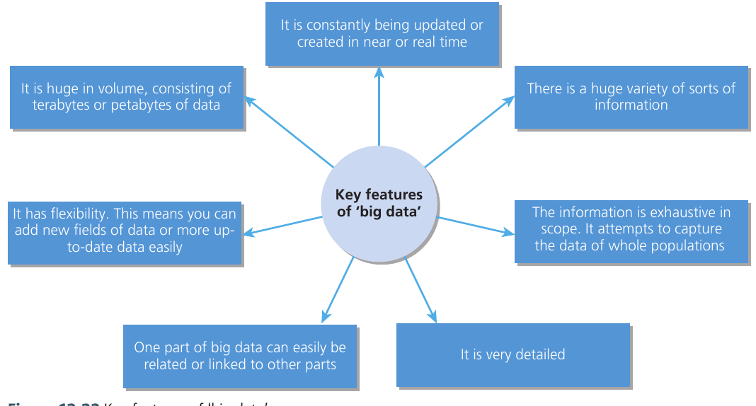
Key characteristics of big data:
Remember the mnemonic VVV-FRED to recall the key features of big data:
- Constantly updated (Velocity) - Information is created or refreshed in near-real time
- Huge volume (Volume) - Consists of terabytes or petabytes of data
- Variety (Variety) - Contains many different types and formats of information
- Flexible - New fields of data can be added or existing data can be updated easily
- Relational - Different parts of big data can easily be linked or connected together
- Exhaustive - Attempts to capture data from entire populations rather than samples
- Detailed - Provides high levels of granular information
Other uses of ICT
Digital technology has become increasingly portable and flexible. Mobile devices now serve as powerful data collection tools in the field, enabling you to gather information through GPS positioning, geolocation tracking, photographs, video clips, annotated sketches, and voice recordings.
Traditional ICT skills remain valuable for geographical analysis. Excel spreadsheets allow you to process and analyze numerical data, while word processing software helps you present findings clearly. Modern mapping technologies have expanded these capabilities significantly.
Digital mapping tools such as Google Maps, Google Earth, Multimap, and Memory-map enable you to present geographical data in engaging and meaningful ways. Remote sensing technology provides additional layers of spatial information for analysis.
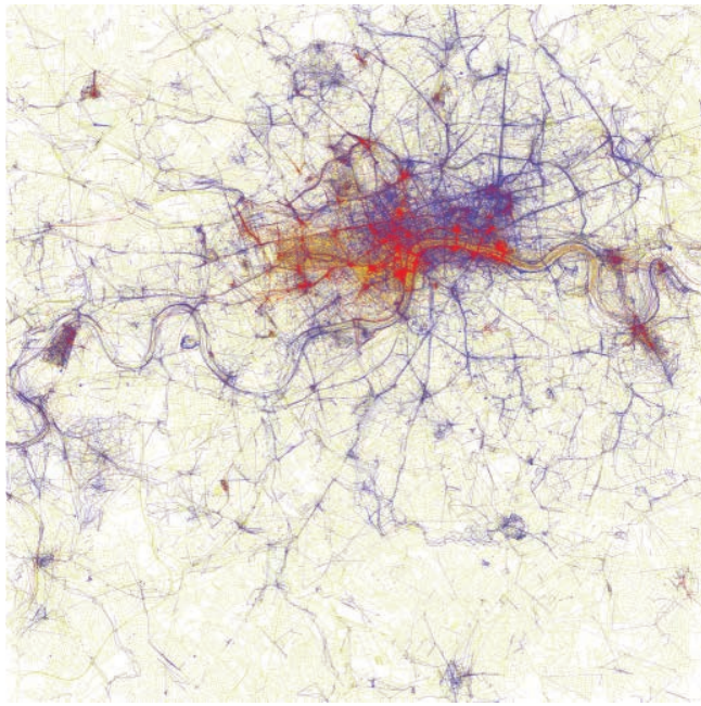
Practical Application: Flickr Tourism Mapping
Data from photo-sharing networks like Flickr can reveal tourist destination patterns. By analyzing when and where people take photographs (whether locals taking pictures throughout the year or tourists visiting for shorter periods), geographers can map tourism flows and identify popular destinations within cities.
This demonstrates how user-generated content can provide insights into human behavior and spatial patterns without traditional survey methods.
Remember!
Key Points to Remember:
-
Electronic databases like ONS, Ordnance Survey, and Digimap provide reliable geographical data for research and analysis
-
Always critically evaluate internet sources by questioning who published it, who wrote it, how old it is, why it exists, and whether it shows bias (use the WWAAH mnemonic!)
-
Crowdsourcing and volunteered geographical information (VGI) enable researchers to access individual-level behavioral data that traditional methods cannot capture
-
Big data is characterized by its enormous volume, constant updating, variety of information types, detailed content, and ability to capture entire populations rather than samples (remember VVV-FRED!)
-
Mobile devices and digital technology provide practical tools for collecting field data including GPS locations, photographs, and annotations