Spatial Patterns of Land Use in Urban Areas (AQA A-Level Geography): Revision Notes
Spatial Patterns of Land Use in Urban Areas
Introduction to urban morphology
Understanding how cities are organised spatially helps us see patterns in where different activities and land uses are located. The arrangement of buildings, streets, and different zones within a city has been shaped by various factors over time.
Urban morphology refers to the spatial structure and organisation of an urban area. It describes the physical layout and patterns of land use within towns and cities.
Traditionally, the layout of urban areas has been heavily influenced by physical geography. However, as technology and human capabilities have advanced, human factors now play a more dominant role in determining how cities are structured, particularly in high-income countries.
Physical factors affecting urban land use
Physical geography still matters when it comes to urban development, though its importance has decreased over time. The natural landscape presents both opportunities and constraints for urban growth.
Relief and drainage
In the past, physical factors such as relief (the shape of the land) and drainage (water flow patterns) were crucial in determining where urban areas developed:
- Early industrial areas were typically located close to rivers, where water power could be harnessed for energy and manufacturing processes
- Flat land was highly valued for industrial development because it made transportation of goods easier, whether by road or rail
- Transport routes naturally followed flatter terrain, making these areas more accessible
Modern significance of physical factors
Today, relief continues to influence urban development, though in different ways:
- Flat land remains easier and cheaper to build on, requiring less engineering work and foundation preparation
- Building on flat land generally attracts higher land values because construction is more straightforward
- However, flat land near rivers may present flood risks, which is an increasingly important consideration with climate change
- In poorer cities, informal settlements often develop on marginal land that is less suitable for development
Example: Rocinha, Rio de Janeiro
Brazil's largest shanty town demonstrates how physical factors still influence urban development in lower-income areas. Rocinha is built on steep, rugged hillside overlooking Rio de Janeiro. The settlement has developed on this challenging terrain because:
- The steeper slopes were undeveloped and available for informal settlement
- Poorer residents had few alternatives for housing
- The poorest parts of the shanty town are located highest up on the hilltop
- Many houses are only accessible by foot due to the steep gradient
This example shows that whilst wealthier areas can overcome physical limitations through engineering and investment, physical geography still significantly constrains development in poorer urban areas.
Land value and spatial patterns
In high-income countries, the primary factor determining land use patterns is land value. This creates distinctive spatial patterns that can be observed in most cities.
Land value is the monetary worth of a plot of land. In urban areas, land values are traditionally highest in the centre of a city where accessibility is greatest.
Peak land value intersection (PLVI)
The concept of the Peak Land Value Intersection helps us understand how land values are distributed across an urban area.
The Peak Land Value Intersection (PLVI) is the point with the highest land value in an urban area. From this point, land prices decline outward, following the theory of distance-decay.
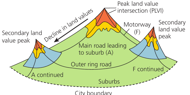
The diagram above shows how land values vary across a city. Key features include:
- The highest land values are found at the PLVI, typically located where major roads intersect in the city centre
- Land values decrease as you move away from the centre towards the suburbs
- The decline follows a predictable pattern known as distance-decay
Distance-decay principle
Distance-decay is a fundamental geographic concept that applies to land values. As the distance from the city centre increases, land values progressively fall. This happens because:
- Accessibility decreases with distance from the centre
- Transport costs increase for businesses located further out
- The concentration of services and infrastructure is greatest at the centre
- Customer footfall is typically highest in central locations
Secondary land value peaks
Whilst the PLVI represents the highest land values, secondary peaks can develop in other locations. These are visible in the land value diagram and occur due to:
- Major transport routes (motorways and main roads) improving accessibility in certain areas
- Development of out-of-town retail and business parks providing alternative commercial centres
- Growth of edge-of-town locations with good transport links
The presence of these secondary peaks has significant implications. Cities no longer have just one dominant centre. Instead, multiple locations compete for businesses and investment, which has contributed to changes in traditional city centre dominance.
Bid-rent theory
The bid-rent theory explains why different types of land use are found at different distances from the city centre. It shows how various land users compete for locations based on their ability to afford high land prices.
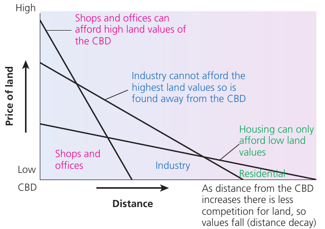
How the theory works
Different types of land users have different capacities to pay for land, which determines where they locate:
Shops and offices:
- Can afford to pay the highest prices for land
- Need to be in the most accessible locations to attract customers and clients
- Benefit most from central locations with high footfall
- Therefore occupy the most expensive land at the PLVI and in the CBD
Industry:
- Cannot afford the highest land values but needs reasonably good accessibility
- Requires larger plots of land for factories and warehouses
- Locates away from the CBD where land is cheaper but still accessible
- Often found along major transport routes
Residential housing:
- Can only afford the lowest land values
- Residents are willing to travel to access work and services
- Occupies the largest area, typically in suburban locations furthest from the centre
- Land values decrease with distance, so housing becomes more affordable further out
The central business district (CBD)
The Central Business District represents the commercial and business heart of a city. Its characteristics are shaped by the high land values found there.
Only highly profitable businesses can afford the premium prices at the PLVI. In UK cities, this prime location has often been occupied by large retailers such as Marks & Spencer, which can generate sufficient revenue to justify the high rents.
Other retailers and commercial enterprises occupy most of the CBD but cannot afford the very highest prices at the most accessible spots. Consequently:
- Smaller retailers and businesses cluster at the edge of the CBD where rents are lower
- There is intense competition for the best locations
- Land uses tend to be multi-storey to maximise the return on expensive land
- The CBD experiences high daytime populations but lower residential populations
As you move outward from the CBD to the suburbs, the pattern follows the bid-rent curves shown in the diagram. Land values fall significantly, and the competition for land decreases. This allows lower-value land uses, particularly housing, to dominate the outer areas.
New urban landscapes
Urban areas are not static. The landscape of cities has changed considerably in recent decades, with significant implications for land use patterns and land values.
Changes in the city centre
Many UK city centres experienced significant decline during the late 20th century, particularly in the 1980s and 1990s. Understanding these changes helps explain current regeneration efforts.
Causes of city centre decline:
The main driver of decline was the development of out-of-town retail parks. These new shopping destinations offered several advantages that drew customers away from traditional city centres:
- Free parking in large, convenient car parks
- Modern, purpose-built facilities
- All shops located on one level for easy access
- Less congestion and easier access by car
Impact on city centres:
As shoppers increasingly chose out-of-town locations, city centres suffered:
- Reduced footfall and customer numbers
- Business closures and rising vacancy rates
- Declining land values in some areas
- High parking costs, traffic congestion, and perceptions of dirt and lack of safety further discouraged visitors
- More recently, competition from internet shopping has added additional pressure
Regeneration strategies:
Since the 1980s, numerous strategies have been developed to reverse city centre decline and restore the attractiveness of traditional centres:
- Creating more appealing shopping environments with pedestrianised areas and improved public realm
- Constructing all-weather shopping malls to compete with out-of-town facilities
- Significantly improving public transport links to increase accessibility
- Establishing business and marketing teams to co-ordinate management of the CBD and organise special events
- Developing mixed-use developments that combine different functions
Town centre mixed development
A key strategy for revitalising city centres has been to encourage a wider range of functions beyond just retail shopping. This approach recognises that successful urban centres need to offer multiple attractions.
Leisure and cultural facilities:
Many cities have invested in expanding leisure offerings in their centres. These include:
- Cinemas and theatres providing evening entertainment
- Cafés, wine bars, and restaurants creating vibrant dining scenes
- Cultural venues and meeting places for community activities
The advantage of this approach is that by offering services at different price points and with varying quality levels, city centres can attract a broader range of people. A greater diversity of visitors helps sustain businesses and creates a more dynamic urban environment.
Public spaces:
Creating attractive public spaces has also been crucial for regeneration. Features include:
- Gardens and green spaces for relaxation
- Squares and plazas for events and gatherings
- Facilities for people-watching and socialising
- Improved street furniture and lighting
These public realm improvements make city centres more pleasant places to spend time, encouraging longer visits and repeat trips. They also help differentiate traditional centres from out-of-town retail parks, which typically lack quality public spaces.
The mixed development approach represents a shift from viewing city centres purely as shopping destinations to seeing them as multifunctional spaces that serve various needs throughout the day and evening.
Key Points to Remember:
-
Urban morphology describes the spatial structure of urban areas, which was historically influenced by physical factors like relief and drainage but is now primarily shaped by economic factors in high-income countries
-
Land value is the key factor determining land use patterns, with values highest at the Peak Land Value Intersection (PLVI) in the city centre and decreasing with distance following the distance-decay principle
-
Bid-rent theory explains the spatial pattern of land uses: shops and offices occupy the expensive CBD locations, industry locates on cheaper land with good accessibility, and residential areas are found furthest from the centre where land is most affordable
-
City centres have changed significantly since the 1980s due to competition from out-of-town retail parks, leading to decline and the need for regeneration strategies
-
Mixed development approaches combining retail, leisure, cultural facilities, and quality public spaces have become central to revitalising city centres and making them attractive multifunctional destinations