Human activity (Edexcel GCSE Geography A): Revision Notes
Human activity in UK landscapes
Introduction
The United Kingdom has been home to human settlements for thousands of years, and this long history of occupation has significantly shaped every aspect of our landscape. From the rolling agricultural fields of East Anglia to the managed forests of Scotland, human influence can be seen everywhere across British terrain. Understanding how people have modified landscapes helps us appreciate the complex relationship between human needs and the natural environment.
Every landscape feature we see today - from field boundaries to forest edges - tells a story of human adaptation and environmental modification spanning millennia.
Agriculture and farming
Agriculture involves the management and cultivation of land specifically for growing crops and raising livestock. This activity has fundamentally transformed large areas of the UK landscape over many centuries.
One of the most visible signs of agricultural modification is the creation of drainage systems. In low-lying areas that would naturally be waterlogged, farmers have constructed networks of drainage ditches to remove excess water and make the land suitable for crop production. These ditches appear as straight blue lines on Ordnance Survey maps and represent a clear example of human intervention in the natural landscape.
The type of farming that develops in different areas depends heavily on the characteristics of the landscape itself. Upland regions with their steeper slopes and thinner soils are typically better suited to sheep farming, where animals can graze on rough grassland. In contrast, the fertile lowland valleys with their deep, nutrient-rich soils and flatter terrain are ideal for arable farming, where crops like wheat, barley, and vegetables can be grown successfully.
Key principle: The relationship between landscape and land use demonstrates how humans adapt their activities to work with, rather than against, the natural characteristics of different areas. This adaptation is essential for sustainable land management.
Forestry and woodland management
Forestry refers to the systematic management of woodland areas primarily for timber production. This practice has created distinctive patterns across the British landscape that differ significantly from natural woodland.
Many upland areas of the UK now feature plantation forests where trees have been deliberately planted in neat, straight rows. These geometric patterns make the forests much easier to manage, harvest, and replant compared to natural woodland. The uniformity of these plantations creates a very different visual appearance from the irregular patterns of naturally occurring forests.
Natural vs. Managed Landscapes: If left completely undisturbed, much of the UK would naturally develop into deciduous woodland dominated by trees like oak, ash, and birch. The conifer plantations we see today represent a deliberate human choice for economic timber production.
Interestingly, large areas have been converted to conifer plantations featuring trees such as spruce and pine. These conifer forests are particularly distinctive because they create dense, dark green blocks across the landscape that stand out clearly from surrounding areas.
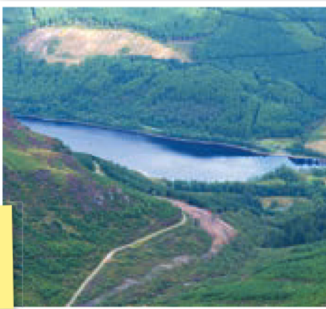
When sections of forest are harvested for timber, cleared areas become visible as patches of lighter-coloured ground among the surrounding woodland. These clearings represent the cyclical nature of commercial forestry, where areas are systematically cut, replanted, and allowed to regrow over periods of several decades.
Settlement patterns and urban development
The location of towns and cities across the UK reflects thousands of years of human decision-making about where to establish communities. Understanding why settlements developed in particular locations helps explain current patterns of human activity across the landscape.
Lowland areas have historically been much more attractive for human settlement than upland regions for several practical reasons. Flat terrain makes construction much easier and less expensive, as there's no need to level steep slopes or deal with challenging gradients. River valleys in lowland areas often provided natural defensive positions, with meandering rivers creating natural barriers around settlements.
Strategic Location Factors: Early settlers chose locations based on multiple practical considerations: ease of construction, natural defences, water access, and transportation routes. These same factors continue to influence urban development today.
These river systems also offered significant economic advantages. Many rivers were deep enough to serve as natural harbours, allowing boats to bring goods and people to inland locations. Shallow crossing points, known as fords, became natural locations for bridges and market towns, as these were often the only places where rivers could be crossed safely.
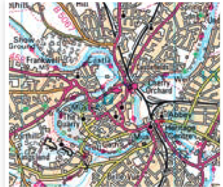
Over time, successful settlements expanded outward from their original cores. In many cases, streams and small rivers that once flowed above ground through growing towns have been redirected into underground channels or tunnels. This allows urban development to continue over areas that were once waterways, though these hidden watercourses often don't appear on modern street maps.
Hidden Geography: Many UK cities have "lost rivers" - watercourses that have been built over or redirected underground. These hidden features still influence drainage patterns and occasionally cause flooding when heavy rainfall overwhelms the buried systems.
The contrast between lowland and upland settlement patterns remains visible today. Upland areas, with their steeper terrain and harsher climate, have always supported much lower population densities and smaller communities compared to the major urban centres that developed in more hospitable lowland locations.
Key Points to Remember:
-
Human influence is everywhere - Every UK landscape has been significantly modified by thousands of years of human activity
-
Farming adapts to landscape - Different types of agriculture suit different terrains, with arable farming in fertile lowlands and livestock grazing in upland areas
-
Forests are managed resources - Most UK woodland consists of carefully planned plantations rather than natural forest, designed for efficient timber production
-
Settlement location matters - Towns and cities developed in lowland areas because flat land, river access, and natural harbours provided practical advantages for communities
-
Landscapes tell stories - Features like drainage ditches, plantation boundaries, and urban river courses reveal how humans have adapted and modified the environment over time