Erosional landforms 1 (Edexcel GCSE Geography A): Revision Notes
Erosional landforms in glaciated upland landscapes
Glaciated upland landscapes contain some of the most dramatic landforms on Earth, created through powerful erosional processes during past ice ages. These distinctive features tell the story of how massive glaciers carved and shaped the mountain terrain over thousands of years.
Understanding glacial erosion
Glacial erosion occurs through several key processes that work together to create these remarkable landforms. Understanding these processes is essential for comprehending how glaciated landscapes develop.
The Three Main Erosional Processes:
Freeze-thaw weathering occurs where water repeatedly freezes and expands in rock cracks, gradually breaking the rock apart. Abrasion happens when the glacier acts like giant sandpaper, scraping and grinding the bedrock as it moves. Plucking occurs when the glacier freezes onto loose rock and pulls it away as the ice advances.
These processes work simultaneously and continuously as glaciers move across the landscape, with their effectiveness depending on factors such as ice thickness, temperature fluctuations, and the type of underlying bedrock.
Formation of corries and tarns
Corries are perhaps the most recognisable features of glaciated upland areas. These are large, bowl-shaped hollows that were carved out by glacial erosion over many thousands of years.
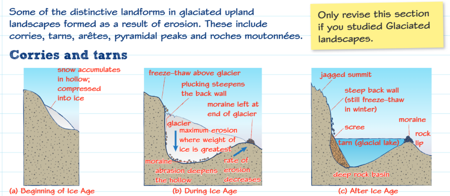
The formation of corries follows a clear sequence that demonstrates the power of glacial erosion over geological time scales.
Formation Process: How Corries Develop
Stage 1 - Pre-glacial conditions: Snow accumulates in small mountain hollows, gradually compressing into ice over time.
Stage 2 - During glaciation: Small glaciers occupy these hollows and begin intensive erosion. Maximum erosion occurs where ice is thickest and heaviest, gradually deepening and widening the hollow through constant abrasion and plucking of the underlying bedrock.
Stage 3 - Post-glacial: As temperatures rise, glaciers melt away, revealing the distinctive corrie landforms we see today.
Many corries now contain small circular lakes called tarns, which formed when meltwater and rainfall collected in the deepened hollow. The steep back wall of the corrie often shows evidence of continued freeze-thaw weathering, creating loose rock debris called scree that tumbles down the slopes.
Arêtes - knife-edge ridges
When two corries develop on opposite sides of a mountain ridge, the erosional processes gradually narrow the land between them, creating a sharp, knife-edged ridge called an arête. These dramatic features form through the combined effects of glacial erosion from both sides and ongoing freeze-thaw weathering.
Arêtes are particularly striking landscape features because of their angular, jagged appearance. The continuous erosion from neighbouring corries means that these ridges become progressively narrower and more precarious over time. Many arêtes in mountain regions like the Lake District and Snowdonia provide challenging routes for experienced hikers and climbers.
Roches moutonnées - sheep-shaped rocks
These distinctive rocky outcrops demonstrate how glacial ice moved across the landscape, creating asymmetric landforms that clearly show the direction of ice flow. The name comes from French, meaning "sheep rocks," because their rounded upstream sides resemble the backs of grazing sheep.
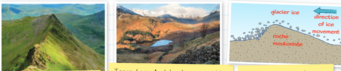
The formation of roches moutonnées involves two different erosional processes working on opposite sides of the rocky outcrop, creating their characteristic asymmetric shape.
Understanding Ice Flow Direction:
On the upstream side (stoss side), the glacier's movement causes smooth abrasion as ice and debris scrape across the rock surface, creating a gentle, polished slope.
On the downstream side (lee side), the glacier plucks away loose rocks through freeze-thaw action, leaving a much rougher, steeper face.
This asymmetric shape makes roches moutonnées excellent indicators of past ice flow direction.
Tarns and glacial lakes
After glaciers retreat, many corries fill with water to create tarns, also known as corrie lakes. These are typically small, roughly circular bodies of water that occupy the deepest part of the corrie basin. The water is often remarkably clear and deep, reflecting the surrounding steep rocky walls.
Several factors help tarns to form and persist in the post-glacial landscape. The glacier's erosional action creates a natural basin by carving the hollow deeper than the surrounding landscape. Additionally, deposited moraine (rock debris carried by the glacier) or a resistant rock lip at the edge of the corrie can act as a natural dam, helping to retain the water that collects from rainfall and mountain streams.
The bigger picture
These erosional landforms rarely exist in isolation. In heavily glaciated mountain areas, you'll often find them grouped together, creating complex landscape patterns that tell the story of past ice ages. Multiple corries may surround a single mountain peak, creating a pyramidal peak with several arêtes radiating outwards. This demonstrates how glacier systems worked together to sculpt entire mountain ranges during the ice ages.
The interconnected nature of these landforms means that understanding one feature helps explain the presence and characteristics of others nearby. Geographers study these landscape patterns to reconstruct past ice flow directions and glacier behaviour.
Key concepts summary
Essential Points to Remember:
- Corries are bowl-shaped hollows carved by glacial erosion, often containing tarns (small lakes) after the ice melts
- Arêtes form when two corries erode back-to-back, creating sharp knife-edge ridges between them
- Roches moutonnées show ice flow direction - smooth on the upstream side from abrasion, rough on the downstream side from plucking
- Glacial erosion works through freeze-thaw weathering, abrasion, and plucking to create these distinctive upland landforms
- These features often occur together in mountain regions, creating dramatic glaciated landscapes that tell the story of past ice ages