Formulating enquiry questions (Edexcel GCSE Geography A): Revision Notes
Formulating enquiry questions
What are enquiry questions and why do we need them?
Enquiry questions are the foundation of successful geographical fieldwork investigations. They provide a clear focus for your research and help you apply your geographical knowledge whilst developing new skills. When conducting river fieldwork, a well-formulated enquiry question will guide every aspect of your investigation, from data collection to analysis and conclusions.
The purpose of these questions is to connect your fieldwork with established geographical theories and models. This allows you to test whether real-world observations match what theory suggests should happen. For rivers, this often involves investigating how channel characteristics change as you move downstream from the source towards the mouth.
A strong enquiry question acts as the backbone of your entire investigation - it determines what data you collect, how you analyse it, and what conclusions you can draw. Without a clear question, your fieldwork lacks direction and purpose.
The six stages of the enquiry process
Your fieldwork investigation should follow a systematic approach with six key stages. Understanding these stages will help you structure your work effectively and ensure you address all the requirements for your exam.
All six stages are interconnected and must relate back to your original enquiry question. Weakness in any one stage will affect the quality of your entire investigation.
Stage 1: Develop a question - This is where you create your focused enquiry question based on geographical theory and the opportunities available at your fieldwork location.
Stage 2: Use a range of techniques and methods - You must collect both quantitative data (numerical measurements) and qualitative data (observations and descriptions) using appropriate geographical techniques.
Stage 3: Process your data and present your data - Organise your collected information into suitable formats such as graphs, tables, and maps that make patterns and trends visible.
Stage 4: Analyse and explain your data - Look for patterns, trends, and relationships in your data, then use geographical knowledge to explain what you have discovered.
Stage 5: Make conclusions - Draw together your findings and relate them back to your original enquiry question, using both your data and supporting written information.
Stage 6: Evaluate your data and data collection methods - Reflect critically on the reliability and accuracy of your methods, identifying limitations and suggesting improvements.
Connecting enquiry questions to geographical theory
Effective enquiry questions often relate to established geographical theories that can be tested through fieldwork. The Bradshaw model is particularly useful for river investigations as it shows the theoretical changes in river characteristics from upstream to downstream locations.
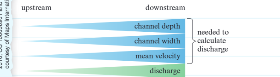
According to this model, as rivers flow downstream, channel depth, channel width, and mean velocity should all increase, leading to higher discharge values. This provides an excellent framework for developing enquiry questions about how river characteristics vary spatially.
The Bradshaw model provides testable predictions that make it ideal for fieldwork investigations. Each of its predictions can be measured using appropriate geographical techniques, allowing you to compare theory with reality.
For example, your enquiry question might be: "How do river channel characteristics vary along the river [name]?" This can then lead to more specific sub-questions such as: "Does the width and depth of the river increase as the river flows downstream?"
A suitable hypothesis based on this theory could be: "The width and depth of the river increase as the river flows downstream."
Worked example: site selection and investigation
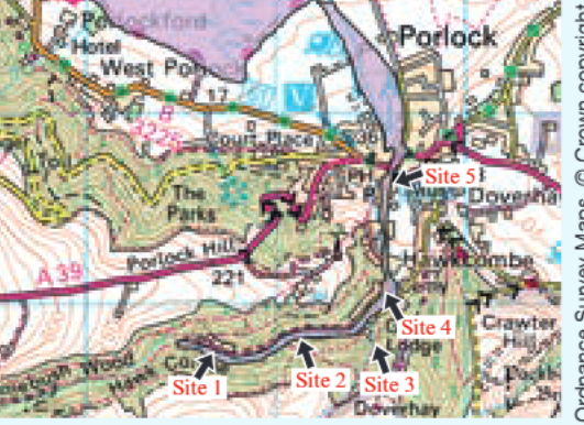
When planning your fieldwork, careful site selection is crucial for answering your enquiry question effectively. The map shows five research sites selected along the Hawkcombe stream, with purple shading indicating flood risk areas.
Worked Example: Evaluating Site Appropriateness
Consider this exam-style question: "Explain one reason why site 3 is not appropriate for comparing the impact of changing river discharge and flood risk with sites 1, 2, 4 and 5."
Analysis: Site 3 is located on a different tributary of the Hawkcombe, outside the main flood area. Including this site in your data collection would provide inaccurate data and lead to incorrect conclusions about discharge patterns and flood risk along the main river channel.
Key Learning: Site selection must ensure all locations are comparable and relevant to your specific enquiry question.
However, not all sites may be appropriate for your specific investigation. The answer demonstrates critical thinking about site selection: Site 3 would provide misleading results because it's not part of the main river system being investigated.
Practical application: analysing river data
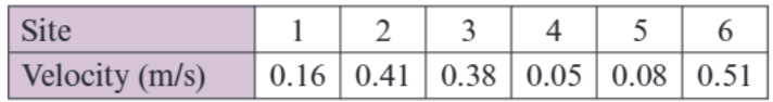
Once you have collected your data, you need to process and analyse it systematically. The velocity measurements shown in the table demonstrate how quantitative data from different sites can be used to test your hypothesis about downstream changes.
Worked Example: Calculating Mean River Velocity
To calculate mean river velocity from the data:
Step 1: Add all velocity measurements together
Step 2: Divide by the number of sites
Remember: Simply calculating averages is not enough - you must analyse whether the data supports your hypothesis and explain any unexpected results using geographical knowledge.
However, statistical analysis alone is insufficient for geographical fieldwork. You need to analyse whether the data supports your hypothesis about downstream changes and explain any unexpected results using your geographical knowledge.
Developing effective enquiry questions
When formulating your enquiry question, consider these key points to ensure your investigation will be both manageable and meaningful.
Your question should be specific enough to investigate thoroughly within the time and resources available, yet broad enough to allow for meaningful geographical analysis. It should connect clearly to established geographical theory or models that you can reference in your analysis.
The best enquiry questions strike a balance between being focused enough to investigate properly and broad enough to demonstrate substantial geographical understanding. They should always connect to theory while being practically achievable in your fieldwork context.
The question should be investigable using appropriate fieldwork techniques for collecting both quantitative and qualitative data. Consider the practical constraints of your fieldwork location and ensure your question can be answered safely and effectively.
Remember that in your exam, you will face questions about at least two stages of the enquiry process, so understanding how your initial question influences every subsequent stage is essential for success.
Key Points to Remember:
- Enquiry questions provide focus and direction for your entire fieldwork investigation
- All six stages of the enquiry process are interconnected and should relate back to your original question
- Effective enquiry questions connect to established geographical theories like the Bradshaw model
- Site selection must be appropriate for your specific investigation and enquiry question
- Both quantitative and qualitative data collection methods are essential for comprehensive analysis
- Your enquiry question must be both specific enough to investigate thoroughly and broad enough for meaningful analysis