Grid references and distances (Edexcel GCSE Geography A): Revision Notes
Grid references and distances
Grid references are essential tools for locating geographical features accurately on Ordnance Survey (OS) maps. Understanding how to use these references and measure distances is a fundamental skill needed for geography examinations and real-world navigation.
Understanding the grid system
OS maps use a coordinate system made up of numbered horizontal and vertical lines that create a grid pattern across the entire map. This systematic approach allows you to pinpoint any location with precision.

The grid consists of:
- Easting lines: Vertical lines that run from west to east (left to right)
- Northing lines: Horizontal lines that run from south to north (bottom to top)
Each line has a unique number, and these numbers increase as you move eastward and northward across the map.
Think of the grid system like a street map of your local area. Just as streets have names or numbers to help you navigate, the grid lines on OS maps have numbers that create a reference system for finding any location quickly and accurately.
4-figure grid references
A 4-figure grid reference identifies a complete grid square on the map. To create a 4-figure reference, you need to find the numbers of the grid lines that form the bottom-left corner of the square containing your feature.
The method follows a simple rule: "along the corridor, up the stairs". This means you always write the easting number first, followed by the northing number.
Worked Example: Creating a 4-figure Grid Reference
If a feature is located in a grid square where the bottom-left corner is formed by easting line 13 and northing line 92:
Step 1: Identify the easting line number = 13 Step 2: Identify the northing line number = 92 Step 3: Write easting first, then northing = 1392
The 4-figure grid reference is 1392.
6-figure grid references
6-figure grid references provide much more precise locations by dividing each grid square into smaller sections. This level of accuracy is often required when pinpointing specific features like telephone boxes, buildings, or landmarks.
To create a 6-figure reference, you mentally divide each edge of the grid square into 10 equal parts. Then you estimate how many tenths along the easting direction and how many tenths up the northing direction your feature is located.
The process involves:
- Start with the 4-figure reference for the grid square
- Estimate tenths along the easting direction (add as third digit)
- Estimate tenths up the northing direction (add as sixth digit)
Worked Example: Creating a 6-figure Grid Reference
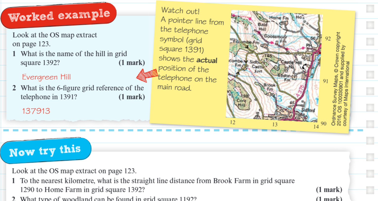
For a telephone symbol located roughly 7/10ths across and 1/10th up within grid square 1391:
Step 1: Start with 4-figure reference = 1391 Step 2: Estimate position across (easting tenths) = 7 Step 3: Estimate position up (northing tenths) = 1 Step 4: Insert the tenths = 137913
The 6-figure grid reference is 137913.
Measuring distances on maps
Distance measurement on OS maps involves two distinct types, each requiring different techniques and equipment.
Understanding the difference between straight line and winding distances is crucial for exam success. Always read the question carefully to determine which type of measurement is required.
Straight line distances

Straight line distances represent the shortest route between two points, often described as "as the crow flies". These measurements ignore terrain features and obstacles, showing only the direct linear distance.
Method for Measuring Straight Line Distances
Step 1: Use a ruler to draw a straight line between the two points Step 2: Measure the length of this line using the ruler Step 3: Convert the measurement using the map's scale line
Winding distances

Winding distances follow curved paths such as rivers, roads, or footpaths. These measurements reflect the actual distance you would travel along these features.
Method for Measuring Winding Distances
Step 1: Use a piece of string to follow the curved route exactly Step 2: Lay the string along the feature, following every bend and curve Step 3: Straighten the string and measure its length with a ruler Step 4: Convert using the scale line
Equipment for examinations
Essential Equipment for Geography Exams
For geography examinations, you'll need specific equipment to measure distances accurately:
- Ruler: Essential for measuring straight line distances and converting string measurements
- String: A 10-centimetre piece is typically provided, but bringing your own ensures you're prepared
- Scale line knowledge: Understanding how to use the map's scale to convert measurements into real-world distances (kilometres or metres)
Converting measurements
After measuring distances with your ruler or string, you must convert these measurements into actual distances using the map's scale line. The scale line shows the relationship between distances on the map and real-world distances.
Most OS maps will require you to convert measurements into either:
- Kilometres (for longer distances)
- Metres (for shorter, more precise measurements)
Always check which unit the question requires and use the appropriate section of the scale line for your conversion.
Practical tips for accuracy
When working with grid references and distances, several techniques can improve your accuracy:
Key Techniques for Improved Accuracy
- Take time to identify grid line numbers carefully before creating references
- When estimating tenths for 6-figure references, visualise the grid square divided into 10 equal strips
- For winding distances, ensure your string follows the exact path of the feature
- Double-check your scale conversions by ensuring the final distance seems reasonable for the journey measured
Understanding pointer lines is also crucial - some map symbols include small lines that indicate the precise location of features, which is particularly important when creating 6-figure references.
Key Points to Remember
- Grid references always follow the pattern "along then up" - easting first, then northing
- 4-figure references identify grid squares, while 6-figure references pinpoint specific locations within those squares
- Straight line distances use a ruler and represent "as the crow flies" measurements
- Winding distances require string to follow curved paths like roads and rivers
- Always convert your measurements using the map's scale line to get real-world distances