Land use and settlement shapes (Edexcel GCSE Geography A): Revision Notes
Land use and settlement shapes
Understanding OS maps and settlements
Ordnance Survey (OS) maps are essential tools in geography that provide detailed information about the landscape and human activity. When studying settlements, these maps help us identify different types of land use, vegetation patterns, communication networks, and the distinctive shapes that settlements take.
What OS maps show us
OS maps contain a wealth of geographical information that helps us understand how humans interact with their environment. The maps display land use patterns, including both settlements where people live and work, and farmland used for agriculture. They also show vegetation coverage such as woodland areas and parklands, which can influence where people choose to settle.
Communication networks are clearly marked on OS maps, including roads and railways that connect different places. These transport links often play a crucial role in determining where settlements develop and how they grow over time. The map key helps you identify these different features and understand what the various symbols and colours represent.
OS maps are invaluable for understanding the relationship between physical geography and human settlement patterns. The detailed symbols and colour coding system allows geographers to quickly identify different land uses and make connections between environmental factors and settlement development.
The framework for describing settlements
When geographers analyse settlements, they use a systematic approach known as the "3 S's" framework. This method ensures that all important aspects of a settlement are considered and described thoroughly.
The 3 S's framework is fundamental to settlement analysis:
- Site - the physical characteristics of the location
- Situation - the location relative to other places and features
- Shape - the pattern the settlement creates when viewed from above
Mastering this framework is essential for effective geographical analysis.
Site characteristics
The site refers to the actual physical characteristics of the place where a settlement is located. These features directly affect how suitable the location is for human habitation and development. Geographers often use the SAGA framework to analyse site characteristics systematically.
The SAGA Framework for Site Analysis:
- Slope - describes whether the land is gentle or steep, which affects building construction and accessibility
- Aspect - refers to the direction the land faces (north, east, south, or west-facing), influencing climate conditions like sunshine and wind exposure
- Ground conditions - includes factors such as flooding risk and foundation stability for building
- Altitude - measures the height above sea level, affecting temperature and accessibility
This systematic approach ensures no important site factors are overlooked in your analysis.
Situation analysis
Situation describes the location of a settlement in relation to other places and geographical features. This includes proximity to other towns and cities, distance from important resources like water sources, and connections to transport networks. A settlement's situation often explains why it developed in that particular location and how it has grown over time.
Settlement shapes
The shape of a settlement refers to the pattern it creates when viewed from above, which you can observe on OS maps. Understanding these shapes helps geographers explain how settlements have developed and what factors influenced their growth.
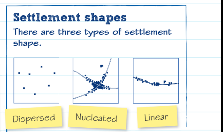
There are three main types of settlement shapes that you need to recognise and understand. Each shape reflects different geographical conditions and development patterns.
Settlement Shape: Dispersed Settlements
Characteristics: Buildings and houses scattered randomly across an area with no clear central focus.
Why they develop: This pattern often develops in rural areas where farming is the main activity, and people need to live close to their individual plots of land. Dispersed settlements are common in areas with poor transport links or where the terrain makes nucleated development difficult.
Map evidence to look for: Isolated farmhouses spread across the landscape, typically in agricultural areas.
Settlement Shape: Nucleated Settlements
Characteristics: Buildings clustered together around a central point, such as a crossroads, market square, or important building like a church.
Why they develop: This concentrated pattern often develops where there are good transport connections or where people benefit from being close together for trade, defence, or social reasons. Most villages and towns show nucleated characteristics.
Map evidence to look for: Dense clustering of buildings around a central feature or intersection.
Settlement Shape: Linear Settlements
Characteristics: Buildings arranged in a roughly straight line, typically following a transport route such as a main road, railway line, or river valley.
Why they develop: This pattern develops when geographical features like valleys or ridges channel development in one direction, or when a transport route provides the main reason for the settlement's existence.
Map evidence to look for: Buildings forming a line along roads, rivers, or other linear features.
Analysing settlement patterns
When describing settlement patterns on maps, you need to provide specific evidence to support your observations. This means using grid references to identify exact locations, naming specific settlements or features, giving distances between places, and indicating directions accurately.
Essential Analysis Approach:
When describing a nucleated settlement, you might explain that the buildings are grouped around a central area, and then provide evidence such as the specific grid reference where this clustering occurs. This approach demonstrates your ability to read maps accurately and use geographical evidence effectively.
Always avoid vague descriptions - use precise map evidence to support every observation you make.
The key to successful settlement analysis is combining your understanding of the three settlement shapes with careful observation of the map evidence. Look for patterns in how buildings are distributed, consider what geographical features might have influenced this distribution, and always support your descriptions with specific details from the map.
Key Points to Remember:
- OS maps show land use, vegetation, and communications that influence settlement development
- Use the 3 S's framework: Site (physical characteristics), Situation (location relative to other places), and Shape (settlement pattern)
- Apply SAGA to analyse site characteristics: Slope, Aspect, Ground conditions, and Altitude
- Recognise three settlement shapes: dispersed (scattered), nucleated (clustered), and linear (in a line)
- Always provide map evidence including grid references, distances, and directions when describing patterns