Tropical Storms and Droughts (OCR GCSE Geography B (Geography for Enquiring Minds)): Revision Notes
Tropical Storms and Droughts
What are tropical storms?
Tropical storms are intense rotating weather systems that develop over warm ocean waters in tropical regions. These powerful storms are characterised by several key features:
- They form above tropical oceans where water temperatures are high
- They generally move from east to west
- Wind speeds exceed 120 km/h
- They can measure up to 650 km in diameter
- They bring extremely heavy rainfall to affected areas
Tropical storms have different names depending on where they occur:
- Hurricanes - Atlantic Ocean and eastern Pacific
- Cyclones - Indian Ocean
- Typhoons - Western Pacific Ocean, particularly around Asia
Despite these different names, they are all the same type of weather system.
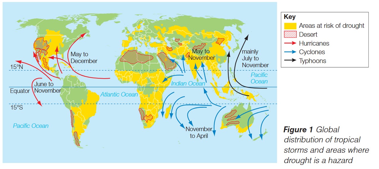
Global distribution of tropical storms
Tropical storms occur in specific regions around the world, typically between approximately 15°N and 15°S of the equator. The map above shows that these storms follow particular paths and occur during specific seasons:
- Hurricanes affect the Atlantic Ocean and eastern Pacific, mainly occurring between May and December
- Cyclones develop in the Indian Ocean, with seasons varying between May and November in the northern Indian Ocean, and November to April in the southern Indian Ocean
- Typhoons form in the western Pacific Ocean, predominantly between July and November
Seasonal Patterns
The seasonal nature of these storms is linked to when ocean temperatures are at their highest in each region, providing the energy needed for storm formation. This explains why different regions experience tropical storms at different times of the year.
What are droughts?
Droughts are extended periods when an area receives significantly less rainfall than normal for that region. This lack of precipitation leads to serious water shortages that can affect people, agriculture, and ecosystems.
Droughts are closely linked to persistent high-pressure weather systems. When high pressure dominates an area for a long time, it prevents rain-bearing clouds from forming, resulting in dry conditions that can last for months or even years.
The High Pressure Connection
High-pressure systems are the key cause of droughts. These systems create descending air that prevents cloud formation and rainfall. When a high-pressure system remains stationary over an area for an extended period, it blocks the normal passage of weather fronts that would bring rain, leading to drought conditions.
Global distribution of droughts
The world map shows that certain regions are particularly vulnerable to drought conditions. Areas at risk of drought are widespread and include:
- Parts of North America, including central and western regions
- Large areas of Africa, particularly in the Sahel region and southern Africa
- Central Asia and parts of the Middle East
- Parts of Australia
- Regions of South America
Some of these areas overlap with existing desert regions, where low rainfall is already the norm. However, drought can also affect areas that normally receive moderate rainfall, making it a hazard that impacts diverse climates.
How tropical storm patterns have changed over time
Understanding long-term changes in tropical storm patterns is challenging. Current evidence does not show a clear pattern of change in the frequency or distribution of tropical storms over recent decades. However, scientists are increasingly concerned about the potential impact of global warming on these weather systems.
As global temperatures rise, ocean temperatures are also increasing. Warmer oceans provide more energy for storm formation, which could potentially lead to more intense tropical storms in the future.
Intensity vs Frequency
This is a crucial distinction: While the number of storms may not necessarily increase, their severity and destructive power could become greater. Future tropical storms may be fewer but more intense, posing greater risks to coastal communities.
How drought patterns have changed over time
Unlike tropical storms, there is clear evidence that drought patterns around the world have changed significantly over the past century. This change is particularly noticeable when examining historical data.
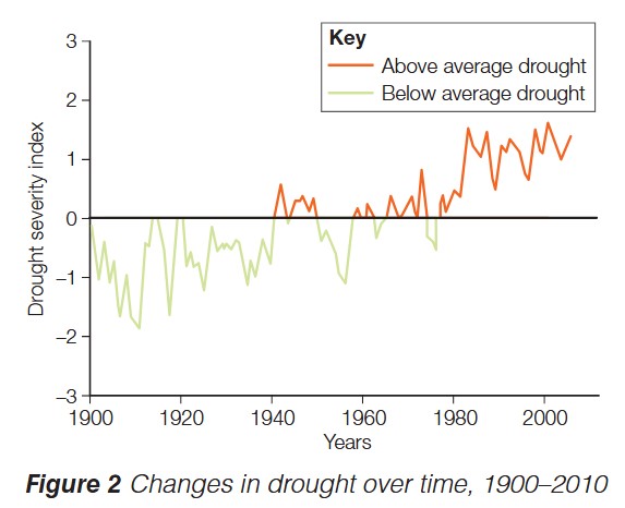
- During the early 1900s, drought conditions were generally below average, meaning droughts were less severe
- From around 1940 onwards, there has been a marked increase in drought severity
- Since approximately 1960, above-average drought conditions have become more common
- The trend shows a clear shift from predominantly below-average drought severity to above-average severity
Understanding the Data
The graph shows relative drought severity compared to a long-term average. Values above zero indicate worse-than-average drought conditions, while values below zero indicate better-than-average conditions (less severe droughts). The upward trend since 1940 is a strong indicator of increasing drought severity globally.
This increase in drought severity is likely linked to long-term climate change. Changes in rainfall patterns and increased evaporation rates, both associated with rising global temperatures, contribute to more severe and prolonged drought conditions in vulnerable regions.
The changing rainfall patterns mean that some areas receive less precipitation than historically expected, while higher temperatures cause more water to evaporate from soil and vegetation, intensifying drought impacts.
Exam guidance
Tips for Exam Success
When answering questions about tropical storms and droughts:
-
Describe questions: Focus on characteristics, distribution, and observable patterns. Use specific facts such as wind speeds (120 km/h), size (up to 650 km diameter), and location (15°N to 15°S)
-
Explain questions: Show your understanding of causes and processes. For example, explain how high pressure causes drought by preventing cloud formation, or how ocean temperature affects tropical storm formation by providing energy
-
Assess/Evaluate questions: Consider evidence of change over time, such as the drought severity data showing increases since 1940, and discuss the reliability of this evidence and potential future impacts
Key Points to Remember:
-
Tropical storms are powerful rotating weather systems with wind speeds exceeding 120 km/h that form over warm tropical oceans and have different names (hurricanes, cyclones, typhoons) depending on their location
-
Droughts are prolonged periods of below-average rainfall linked to persistent high-pressure systems, causing water shortages
-
Tropical storms follow seasonal patterns and occur in specific belts around the tropics, generally between 15°N and 15°S
-
Clear evidence shows that drought severity has increased globally since 1940, likely due to climate change affecting rainfall and evaporation patterns
-
Global warming may increase the intensity of tropical storms in the future by raising ocean temperatures, even if the overall number of storms remains similar