Skew Boreholes (Leaving Cert DCG): Revision Notes
Skew Boreholes
What are skew boreholes?
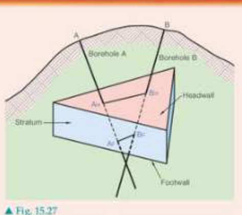
Skew boreholes are non-parallel boreholes used in geological surveying to determine important characteristics of underground rock formations. Unlike parallel boreholes, skew boreholes are drilled at different angles and directions, making them particularly useful for analysing the strike, dip, and thickness of geological strata.
The term "skew" means the boreholes are not parallel to each other. This arrangement allows geologists and surveyors to gather more comprehensive information about underground rock layers than would be possible with parallel drilling alone.
Purpose and applications
Skew boreholes serve several important functions in geological analysis. The primary applications include gathering critical data about subsurface formations that would be impossible to obtain through other drilling methods.
- Strike determination - finding the horizontal direction of rock layers
- Dip measurement - calculating the angle at which rock layers are inclined
- Thickness calculation - measuring how thick the rock formations are
- Geological mapping - creating accurate underground maps for mining or construction
These measurements are essential for understanding subsurface geology, which is crucial for mining operations, construction projects, and geological surveys. Accurate strike and dip measurements can mean the difference between successful and failed engineering projects.
Setting up the problem
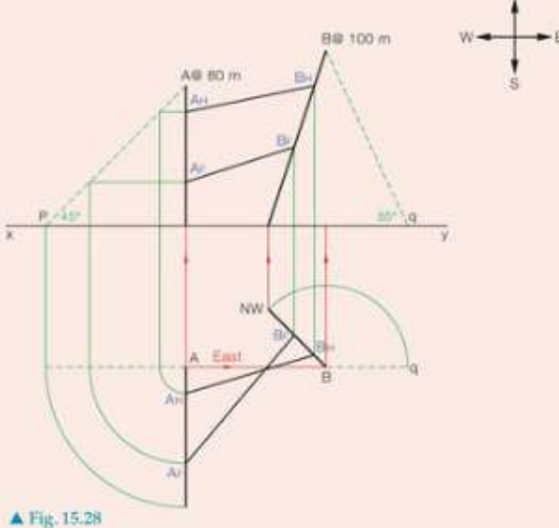
When working with skew boreholes, you typically start with a contour map showing the surface topography. The initial setup phase requires careful planning and precise measurements to ensure accurate results.
The setup involves several critical steps:
- Identifying borehole positions - marking where each borehole will be drilled on the map
- Determining borehole directions - establishing the compass bearing for each hole
- Setting inclination angles - defining how steeply each borehole descends
- Recording elevations - noting the surface height at each borehole location
Construction methods and procedures
The construction process follows a systematic approach using geometric projection techniques. This methodical approach ensures that all measurements and calculations will be accurate and reliable.
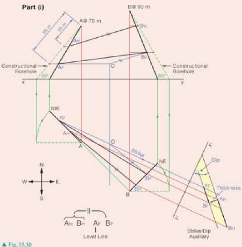
Worked Example: Step-by-step construction
Step 1: Draw the site plan - establish borehole positions with correct compass bearings
Step 2: Project points to elevation - create elevation views showing the vertical relationships
Step 3: Construct the boreholes - draw each borehole at its specified angle and direction
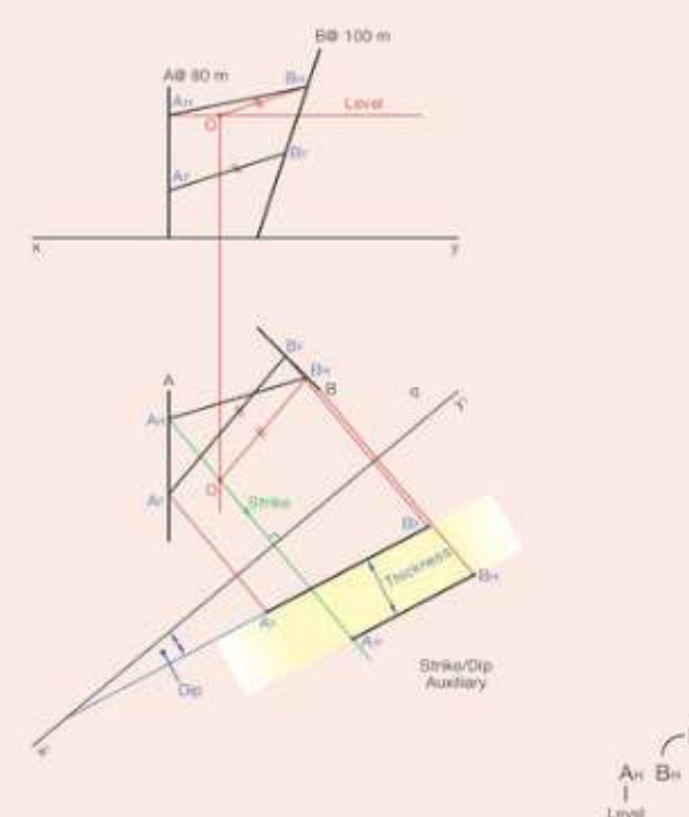
Step 4: Mark intersection points - identify where boreholes intersect the geological stratum
Step 5: Create auxiliary views - develop additional views to reveal true measurements
The key principle is that by intersecting the same geological layer with two non-parallel boreholes, you can determine the true orientation and dimensions of that layer.
Finding strike, dip and thickness
Once the boreholes are constructed, you can extract the geological measurements. Each measurement provides specific information about the geological formation's orientation and dimensions.
Strike
The strike represents the horizontal direction of the rock layer. It appears as a horizontal line when viewed perpendicular to the geological formation.
To find the strike:
- Connect points where both boreholes intersect the same geological level
- The direction of this line gives the strike bearing
Dip
The dip is the angle at which the rock layer slopes downward from horizontal.
To measure dip:
- Create an auxiliary view perpendicular to the strike direction
- Measure the angle between the stratum and a horizontal reference line
- This gives the true dip angle
Thickness
The thickness of the geological layer can be determined by:
- Measuring the vertical distance between the top and bottom surfaces of the stratum
- Using the intersection points from both boreholes to establish these surfaces
- Calculating the perpendicular distance between the surfaces
Auxiliary views and projections
Auxiliary views are essential for finding accurate measurements from skew boreholes. These special projection techniques help reveal the true size and orientation of geological features that may appear distorted in standard plan and elevation views.
Auxiliary views are particularly important because the true dip of a geological formation can only be seen when viewing perpendicular to the strike direction. Without proper auxiliary views, measurements will be inaccurate.
Creating auxiliary views
- Choose the viewing direction - typically perpendicular to the strike for dip measurements
- Project all relevant points - transfer intersection points from other views
- Construct the new view - show the geological formation in its true orientation
- Take measurements - extract accurate angles and distances
True dip and apparent dip
Understanding the difference between true dip and apparent dip is crucial for accurate geological analysis. This distinction is fundamental to proper geological interpretation.
True dip
True dip represents the maximum angle of inclination of a geological stratum. It can only be measured in a direction perpendicular to the strike. This is the most important measurement for geological purposes as it shows the actual steepness of the rock layer.
Apparent dip
Apparent dip is the angle of inclination seen when viewing the stratum from any direction other than perpendicular to the strike. Apparent dip measurements are always less than or equal to the true dip angle. They provide useful information but must be distinguished from true dip values.
Key differences:
- True dip is always the maximum possible angle
- Apparent dip varies depending on viewing direction
- True dip is measured perpendicular to strike
- Apparent dip can be measured from any direction
Key Points to Remember:
- Skew boreholes are non-parallel - this arrangement allows comprehensive geological analysis of underground formations
- Strike runs horizontally - it shows the compass direction of the geological layer's horizontal trend
- Dip measures inclination - it shows how steeply the rock layer slopes downward from horizontal
- Auxiliary views reveal true measurements - use perpendicular viewing directions to find accurate strike, dip and thickness values