Worked Examples (Leaving Cert DCG): Revision Notes
Worked Examples
Grid construction and contour techniques
When working with geologic geometry, accurate grid construction forms the foundation of all technical drawings. The key principle involves using perpendicular measurements to ensure precise spacing and alignment.
Perpendicular relationships are fundamental to all geometric constructions in geology. When measurements deviate from perpendicular, errors compound throughout the entire drawing system.
Understanding grid systems
Grid construction requires careful attention to perpendicular relationships. When measurements are taken perpendicular to a baseline, the spacing between lines remains equal throughout the drawing. This consistency is crucial for maintaining scale accuracy across the entire grid system.
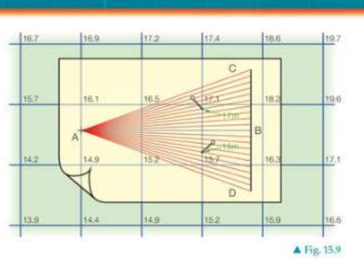
The process involves dividing grid squares proportionally. When working with contours, the sides of grid squares and the number of divisions must be sufficient to handle the largest differences in levels between adjacent corners of the grid.
Scale and interpolation methods
A common working scale of 1:200 is used for drawing grids and plotting contour lines at 1-metre vertical intervals. This scale provides adequate detail while maintaining drawing clarity.
Contour interpolation involves finding intermediate contour values between known elevation points. This technique uses proportional division of grid sides to determine where specific contour lines should cross. The spacing between profile lines corresponds to the scaled equivalent measurements on the ground.
Profile construction from topographic maps
Creating cross-sectional profiles from contour maps is a fundamental skill in geologic geometry. This process transforms two-dimensional contour information into clear vertical sections showing terrain features.
Step-by-step profile construction
Worked Example: Creating a Cross-Sectional Profile
The method involves several key stages:
-
Establish the profile line - Draw a straight line (such as line AB) across the contour map to define the cross-section path
-
Project intersection points - Mark where each contour line crosses the profile line, noting the elevation values
-
Create the vertical scale - Set up a vertical axis with appropriate height intervals to match the contour spacing
-
Plot elevation points - Transfer each intersection point to the correct height on the vertical profile
-
Connect the points - Draw smooth curves connecting the plotted points to show the terrain profile
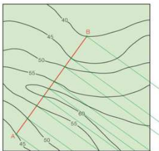
The resulting profile reveals the true shape of the landscape along the chosen line, making it easier to understand slopes, valleys, and ridges that might not be immediately obvious from the contour map alone.
Practical applications in mining geometry
Geologic geometry principles extend beyond basic surveying into practical applications such as mining operations. Understanding how geological features behave in three dimensions is essential for mining planning and resource extraction.
Mining operations must account for the complex three-dimensional nature of geological formations. Rock layers and mineral deposits rarely maintain consistent properties throughout their extent, requiring careful geometric analysis for successful extraction planning.
Understanding strata and mineral deposits
Mining operations must account for the geometry of geological formations. Rock strata (layers) and mineral deposits have definite boundaries and orientations. These formations may be planar (flat) on top and bottom surfaces, but their positions can vary significantly due to geological processes.
Key considerations include:
- Outcrop identification - Points where geological formations reach the surface and become visible
- Strata thickness - The vertical extent of rock layers affects mining feasibility
- Deposit geometry - The three-dimensional shape of mineral deposits determines extraction methods
Mining companies use geometric principles to map underground resources and plan extraction routes. Accurate geometric understanding helps minimise costs while maximising resource recovery.
The surface expression of geological features provides starting points for mining operations. However, formations rarely maintain consistent thickness or orientation throughout their extent, requiring careful geometric analysis for successful extraction planning.
Key Points to Remember:
-
Perpendicular measurements are essential for accurate grid construction and maintain consistent spacing throughout technical drawings
-
Scale consistency (such as 1:200) ensures that measurements and proportions remain accurate across the entire drawing
-
Contour interpolation uses proportional division to find intermediate elevation values between known points on the grid
-
Profile construction transforms contour maps into clear cross-sectional views by projecting intersection points onto vertical scales
-
Mining applications demonstrate how geologic geometry principles solve real-world problems in resource extraction and geological mapping