Processes and Landforms (Grade 10 NSC Matric Geography): Revision Notes
Processes and Landforms
Understanding the relationship between plate movement and landform creation is fundamental to geomorphology. The Earth's surface is constantly being shaped by the interaction of tectonic plates at three main types of boundaries. Each boundary type creates distinctive processes and landforms that help us understand how our planet's surface evolves over time.
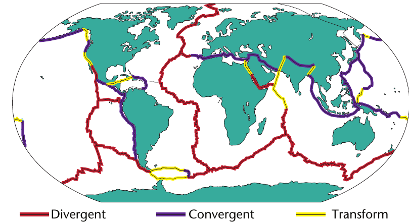
The world map above shows the global distribution of plate boundaries, with red lines marking divergent boundaries where plates separate, purple lines showing convergent boundaries where plates collide, and yellow lines indicating transform boundaries where plates slide past each other.
The global network of plate boundaries forms a interconnected system where geological activity at one boundary can influence processes at distant locations. This interconnectedness helps explain why major earthquakes and volcanic eruptions often occur in clusters along these boundary zones.
Understanding plate boundary processes
The principles behind plate movement are relatively straightforward, but they create some of the most dramatic landforms on Earth. Plate boundaries are zones of intense geological activity where the Earth's crust is either created, destroyed, or transformed. The type of boundary determines what processes occur and what landforms develop.
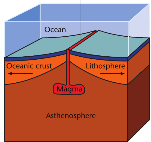
This cross-section illustrates the basic structure of oceanic lithosphere, showing how the rigid outer layer sits above the more fluid asthenosphere. The movement of material in the asthenosphere drives plate motion and creates the conditions for landform development.
The key to understanding landform creation lies in recognizing that different boundary types produce fundamentally different processes. Divergent boundaries create new crust, convergent boundaries destroy or deform existing crust, and transform boundaries simply rearrange existing crust without creating or destroying it.
Landforms associated with divergent plate boundaries
Divergent boundaries are locations where tectonic plates move away from each other. This separation creates space that must be filled, leading to volcanic activity and the formation of new crustal material. There are two main settings where divergent boundaries occur: between oceanic plates and within continental crust.
Mid-ocean ridges
When two oceanic plates diverge, they create underwater mountain ranges called mid-ocean ridges. These ridges form the longest mountain chain on Earth, though most of it lies hidden beneath the ocean surface.
The process begins deep in the mantle where convection currents bring hot material upward. As the oceanic plates separate, magma rises from the asthenosphere to fill the gap. This magma cools and solidifies to form new oceanic crust, creating the characteristic ridge structure.
Mid-ocean ridges are not static features. They can shift position over geological time as plate motion patterns change. The spreading rate at different ridges varies considerably, from slow-spreading ridges that create less than 2 cm of new crust per year to fast-spreading ridges that can produce over 10 cm annually.
The Mid-Atlantic Ridge provides an excellent example of this process. It runs the entire length of the Atlantic Ocean, separating the American plates from the European and African plates. The ridge represents the boundary between the South American and North American plates on the west side, and the African and Eurasian plates on the east side.
Volcanic activity along mid-ocean ridges can sometimes create islands when the volcanic material builds up enough to reach the ocean surface. Iceland is a famous example of this process, where volcanic activity along the Mid-Atlantic Ridge has created a substantial landmass.
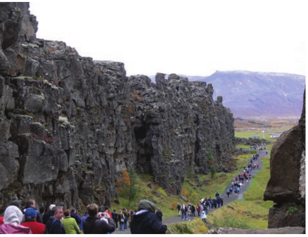
This photograph shows tourists walking through a dramatic rift valley in Iceland, where the separation of plates has created towering basalt cliffs and narrow gorges that demonstrate the power of divergent plate processes.
Continental rifting
When divergent forces affect continental crust, the process is quite different from oceanic divergence. Continental crust is thicker and less dense than oceanic crust, so it behaves differently under stress.
The rifting process occurs in stages. Initially, convection currents in the mantle create an upward bulge or dome in the continental crust. As this dome rises, it stretches and begins to crack. The stretched crust then starts to subside, creating a rift valley with steep walls on either side.
The East African Rift Valley represents the world's best example of active continental rifting. This massive geological feature extends from the Red Sea in the north to Mozambique in the south, creating a distinctive landscape of deep lakes, steep escarpments, and volcanic activity. Scientists predict that if rifting continues, the eastern part of Africa will eventually separate from the main continent, forming a new ocean basin.
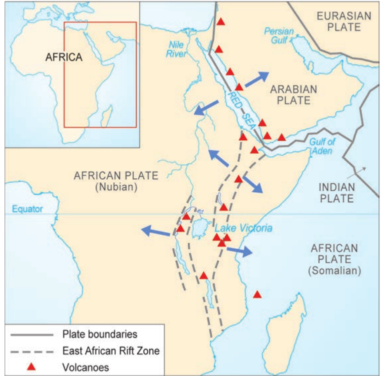
This detailed map shows the East African Rift System, illustrating how the African continent is slowly being pulled apart. The red triangles mark active volcanoes associated with the rifting process, while the dashed lines show the main rift zones where the continent is separating.
The rifting process creates several distinctive landforms:
- Rift valleys: Long, narrow depressions with steep sides
- Fault scarps: Steep cliffs created by vertical movement along fault lines
- Horst and graben structures: Raised blocks (horst) and dropped blocks (graben) created by differential movement
- Volcanic cones: Formed where magma reaches the surface through weakened crust
- Deep lakes: Often formed in the deepest parts of rift valleys
If continental rifting continues for millions of years, it can eventually lead to the complete separation of a continent and the formation of a new ocean. The Red Sea represents an advanced stage of this process, where the Arabian Peninsula has separated from Africa and seawater has flooded the resulting depression.
Landforms associated with convergent plate boundaries
Convergent boundaries occur where tectonic plates move towards each other. The collision or convergence of plates creates some of the Earth's most spectacular landforms, including mountain ranges, deep ocean trenches, and chains of volcanoes. The specific landforms that develop depend on the types of crust involved in the collision.
There are three main types of convergent boundaries:
- Ocean plate converging with another ocean plate
- Ocean plate converging with a continental plate
- Continental plate converging with another continental plate
Ocean-ocean convergence
When two oceanic plates converge, one plate typically slides beneath the other in a process called subduction. The subducting plate is usually the older, denser, and cooler of the two plates. As it descends into the mantle, it begins to melt, creating magma that rises to form underwater volcanoes.
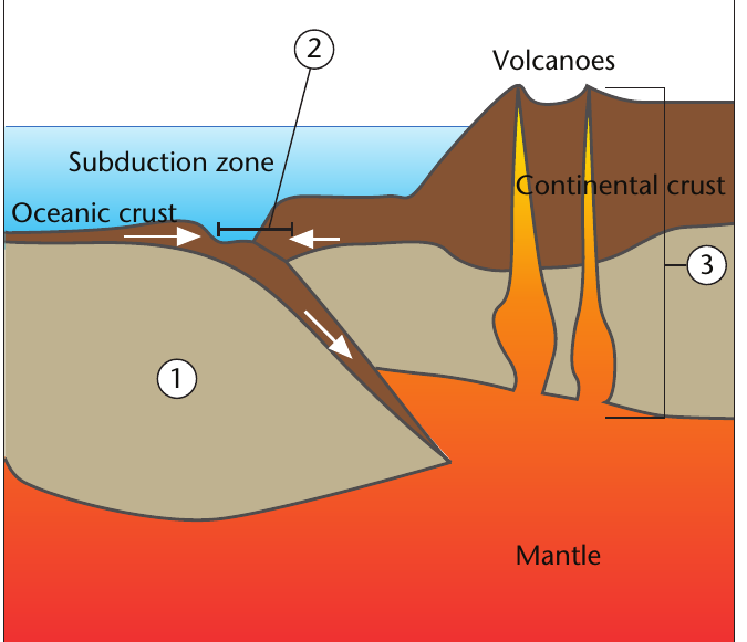
This cross-section shows the subduction process, where the oceanic crust on the left is being forced under the continental crust on the right. The numbers indicate different stages of the process, with volcanic activity occurring where the subducted material melts and rises.
The subduction process is driven by the density difference between the oceanic plates. As oceanic crust moves away from mid-ocean ridges, it cools and becomes denser. Eventually, it becomes dense enough to sink back into the mantle, completing the cycle of oceanic crust formation and destruction.
Over time, these underwater volcanoes can build up enough material to emerge above sea level, forming chains of volcanic islands called island arcs. The Japanese islands, the Philippines, and the Caribbean islands are all examples of island arcs formed by ocean-ocean convergence.
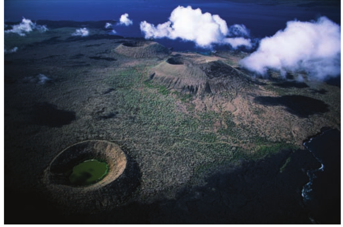
This aerial photograph shows a volcanic island with multiple craters and a distinctive crater lake, typical of the volcanic islands formed at convergent plate boundaries.
The subduction process also creates the deepest parts of the ocean - ocean trenches. These form where the oceanic plate bends downward as it begins its descent into the mantle. The Mariana Trench in the Pacific Ocean, which reaches depths of over 11 kilometres, is the deepest known part of Earth's surface.
Ocean-continental convergence
When an oceanic plate converges with a continental plate, the denser oceanic plate is forced to subduct beneath the lighter continental plate. This process creates some of the world's most impressive mountain ranges and volcanic chains.
As the oceanic plate descends, several processes occur:
- The oceanic plate melts as it encounters higher temperatures and pressures
- The resulting magma is less dense than the surrounding rock and rises upward
- Volcanic eruptions occur where this magma reaches the surface
- The continental crust is compressed and uplifted, forming mountains
The Andes Mountains along South America's western coast provide an excellent example of this type of convergent boundary. The Nazca Plate (oceanic) is subducting beneath the South American Plate (continental), creating the long chain of mountains and active volcanoes that characterise this region. This process has been ongoing for millions of years and continues today, making the Andes one of the most seismically active regions on Earth.
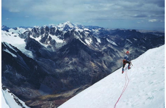
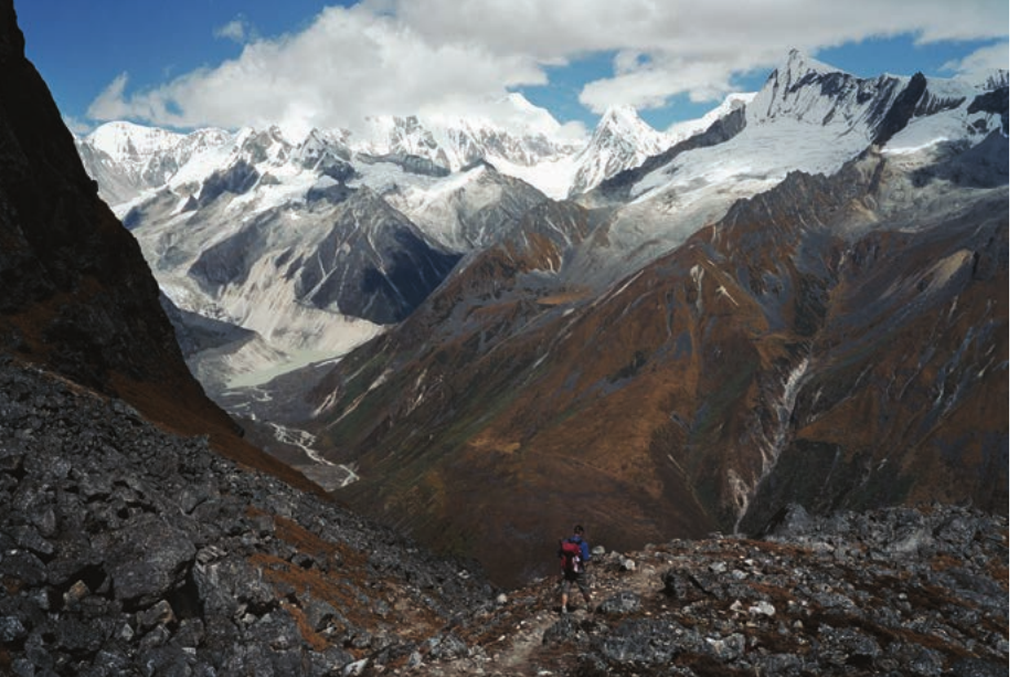
This dramatic photograph shows a mountaineer in the high peaks of a major mountain range, illustrating the extreme altitudes reached by mountains formed through plate convergence.
The landforms created by ocean-continental convergence include:
- Volcanic mountain ranges: Formed by magma rising from the subducted oceanic plate
- Deep ocean trenches: Created where the oceanic plate begins to bend downward
- Coastal mountain ranges: Formed by compression and uplift of continental crust
- Volcanic arcs: Lines of volcanoes running parallel to the coast
Continental-continental convergence
When two continental plates converge, neither can subduct because both are composed of relatively light, buoyant rock. Instead, the collision results in intense compression, folding, and uplift of the continental crust. This process creates the world's highest mountain ranges.
The Himalayas represent the most spectacular example of continental-continental convergence. These mountains formed when the Indian subcontinent collided with the Eurasian plate approximately 50 million years ago. The collision continues today, with the Himalayas rising at approximately 1 centimetre per year and generating frequent earthquakes throughout the region.
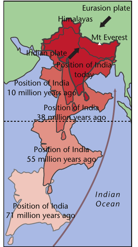
This map shows the northward journey of the Indian plate over the past 71 million years. The different colored areas represent India's position at various time periods, clearly showing how the subcontinent travelled from near Madagascar to its current position against the Eurasian landmass.
The collision process created several distinctive features:
- Fold mountains: Created by compression and buckling of rock layers
- Thrust faults: Where rock layers are pushed up and over other layers
- High plateaus: Elevated regions behind the main mountain front
- Deep valleys: Carved by rivers cutting through the uplifted terrain
This high-altitude photograph shows the dramatic landscape typical of major mountain ranges formed by continental collision, with snow-capped peaks, glaciated valleys, and rugged terrain extending to the horizon.
The Himalayan collision zone extends far beyond the visible mountain range. The compressive forces affect a region over 2000 kilometres wide, creating the Tibetan Plateau and influencing geological processes across much of Central Asia.
Landforms associated with transform plate boundaries
Transform boundaries represent a fundamentally different type of plate interaction. Unlike divergent and convergent boundaries where crust is either created or destroyed, transform boundaries involve plates sliding horizontally past each other. No new crust is formed, and no existing crust is destroyed along these boundaries.
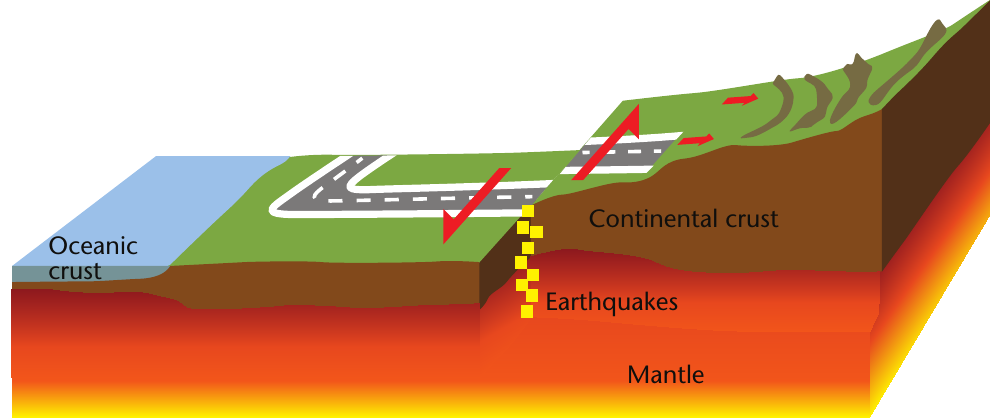
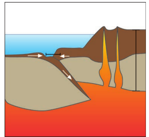
This geological cross-section shows the structure of a transform boundary, with the yellow squares marking earthquake locations along the fault line. The red arrows indicate the direction of plate movement, showing how the plates slide past each other.
The horizontal movement along transform boundaries creates several characteristic features:
- Fault lines: Linear breaks in the Earth's crust where movement occurs
- Offset streams and landforms: Geographic features displaced by fault movement
- Earthquake activity: Caused by the grinding and sticking of plate edges
- Fault scarps: Steep slopes created by vertical displacement along faults
The San Andreas Fault system
The San Andreas Fault in California provides the world's most famous example of a transform plate boundary. This fault system marks the boundary between the Pacific Plate and the North American Plate.
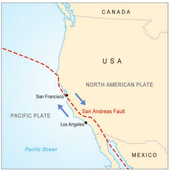
This map shows the San Andreas Fault running through California, with blue arrows indicating the northwest movement of the Pacific Plate relative to the North American Plate. Major cities like San Francisco and Los Angeles are located directly on or near this fault system.
The Pacific Plate moves northwestward at approximately 5 centimetres per year relative to the North American Plate. This seemingly slow movement has created major earthquake hazards for California's cities. The 1906 San Francisco earthquake and the 1994 Northridge earthquake are examples of the devastating effects that can result from sudden movement along transform boundaries.
The Pacific Plate movement has several important consequences:
- Frequent earthquakes: The grinding motion creates regular seismic activity
- Lateral displacement: Geographic features are gradually offset over time
- Risk to urban areas: Major cities lie directly on the fault system
- Landscape modification: Rivers, roads, and other features show evidence of displacement
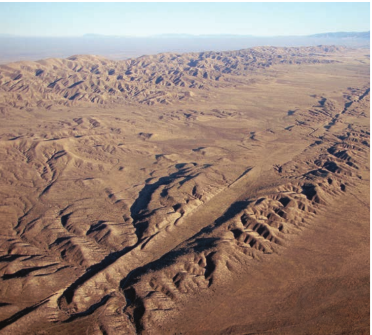
This aerial photograph shows the characteristic landscape created by transform fault activity, with complex canyon systems and eroded terrain typical of areas affected by horizontal plate movement.
Transform boundaries often connect other types of plate boundaries. Many occur as short segments linking spreading centres along mid-ocean ridges, allowing the overall divergent movement to occur along curved plate edges. This interconnected nature means that changes in one boundary type can influence activity at connected transform boundaries.
Volcanic processes and landform creation
Volcanic activity plays a crucial role in creating landforms at plate boundaries. The type and intensity of volcanic activity depend on the plate boundary setting and the composition of the magma involved.
This cross-sectional diagram illustrates how volcanic processes work, showing magma (in red/orange) rising through rock layers to reach the surface. The white arrows indicate the movement of magma and other geological processes.
Different plate boundary settings produce different types of volcanic activity:
At divergent boundaries: Volcanic activity tends to be relatively gentle, with fluid basaltic lava creating new oceanic crust or filling continental rift valleys.
At convergent boundaries: Volcanic activity is often more explosive, with thicker, gas-rich magma creating steep-sided volcanic cones and potentially dangerous eruptions.
At hotspots: Some volcanic activity occurs away from plate boundaries at locations called hotspots, where plumes of hot material rise from deep in the mantle.
The composition of volcanic rocks provides important clues about the tectonic setting where they formed. Basaltic rocks typically form at divergent boundaries, while more silica-rich rocks like andesite and rhyolite are common at convergent boundaries where crustal materials are melted and recycled.
The landforms created by volcanic activity include:
- Shield volcanoes: Broad, gently-sloped mountains built by fluid lava flows
- Stratovolcanoes: Steep-sided cones built by alternating layers of lava and ash
- Volcanic plateaus: Large areas covered by successive lava flows
- Calderas: Large circular depressions formed by volcanic collapse
- Volcanic islands: Isolated landmasses built entirely by volcanic activity
Key Points to Remember:
- Divergent boundaries create new crust through volcanic activity, forming mid-ocean ridges in oceans and rift valleys on continents
- Convergent boundaries involve plate collision and create the world's major mountain ranges, ocean trenches, and volcanic arcs through subduction processes
- Transform boundaries involve horizontal plate sliding, creating fault systems and earthquake activity without forming or destroying crust
- The type of crust involved (oceanic vs continental) determines which specific landforms develop at convergent boundaries
- Ongoing plate movement means these processes continue today, making plate boundary regions prone to earthquakes, volcanic eruptions, and gradual landscape change