Volcanic and Earthquake Zones (Grade 10 NSC Matric Geography): Revision Notes
Volcanic and Earthquake Zones
What are volcanic and earthquake zones?
Volcanic and earthquake zones are areas around the world that have experienced some form of tectonic activity in recent times. These zones represent the most geologically active regions on Earth, where the movement of tectonic plates creates conditions for earthquakes and volcanic eruptions to occur.
Understanding these zones is crucial because they help us predict where future geological hazards might occur and allow communities to prepare accordingly.
Global patterns of geological activity
Our planet experiences constant geological activity. Scientists record impressive numbers each day:
Daily Global Geological Activity:
- At least 50 earthquakes occur daily around the world
- Most of these earthquakes are minor and cause no damage to people or property
- Approximately 50 volcanoes erupt each year globally
- Scientists estimate there are about 2,000 active or potentially active volcanoes worldwide
These statistics show us that geological activity is a normal and ongoing process on Earth, not just occasional dramatic events.
Distribution of earthquake zones
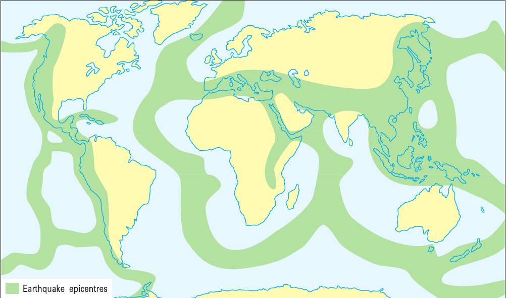
The world's earthquake zones follow very clear patterns. When we look at where earthquakes occur most frequently, we can see that they are not randomly distributed across the globe. Instead, they form distinct belts or zones that wrap around the Earth.
Earthquakes are not randomly distributed across the globe - they follow specific patterns that tell us something important about Earth's structure.
The most prominent earthquake zone surrounds the Pacific Ocean, creating what geologists call the Pacific Ring of Fire. Other significant earthquake zones include:
- The Mediterranean region
- Areas along mid-ocean ridges in the Atlantic Ocean
- Mountain ranges like the Himalayas
- Transform fault systems
Distribution of volcanic zones
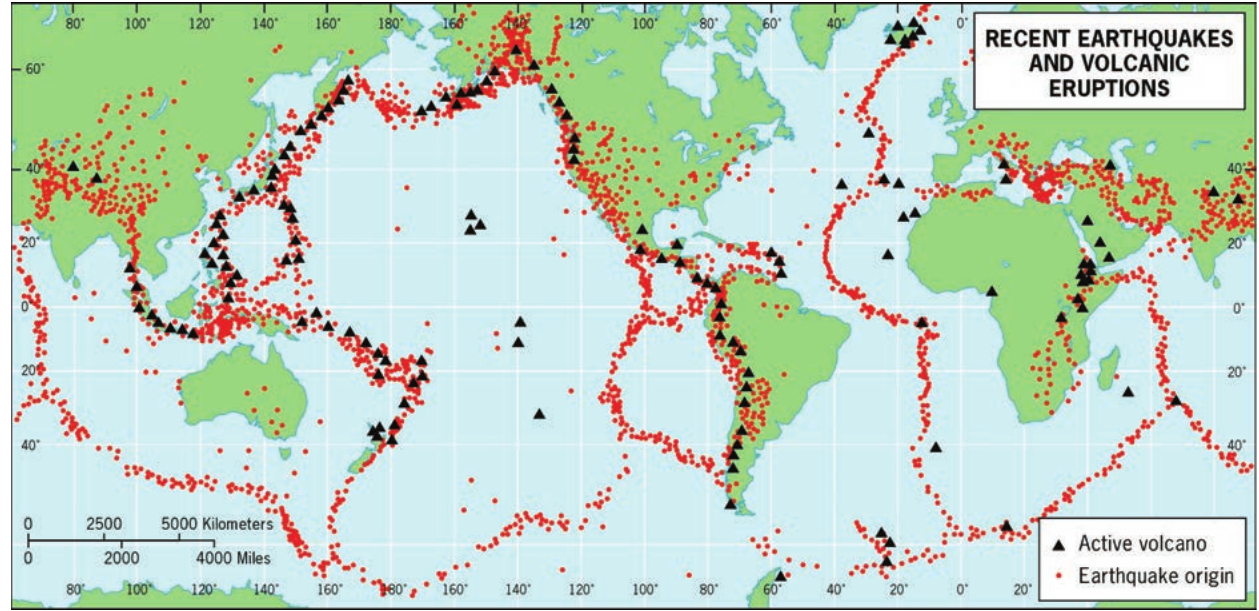
Active volcanoes show a very similar distribution pattern to earthquakes. The world map of recent earthquakes and volcanic eruptions reveals that these two types of geological activity occur in the same regions. This is not a coincidence - it tells us something important about what causes both phenomena.
The fact that earthquakes and volcanic activity occur in the same regions is not a coincidence - both are caused by the same underlying geological processes.
The Pacific Ring of Fire again stands out as the most active region, containing the majority of the world's active volcanoes. This zone circles the Pacific Ocean, affecting countries from Chile and California in the east to Japan, Indonesia, and New Zealand in the west.
Why do these patterns exist?
The reason earthquake and volcanic zones follow these specific patterns lies in plate tectonics. The Earth's outer shell consists of large pieces called tectonic plates that are constantly moving, albeit very slowly. Where these plates meet - at their boundaries - is where most geological activity occurs.
Most geological activity occurs at plate boundaries - where tectonic plates meet and interact with each other.
There are three main types of plate boundaries:
- Divergent boundaries - where plates move apart
- Convergent boundaries - where plates move towards each other
- Transform boundaries - where plates slide past each other
Each type of boundary creates different conditions that can lead to earthquakes, volcanic activity, or both.
Real-world examples
Volcanic eruption: Iceland 2010
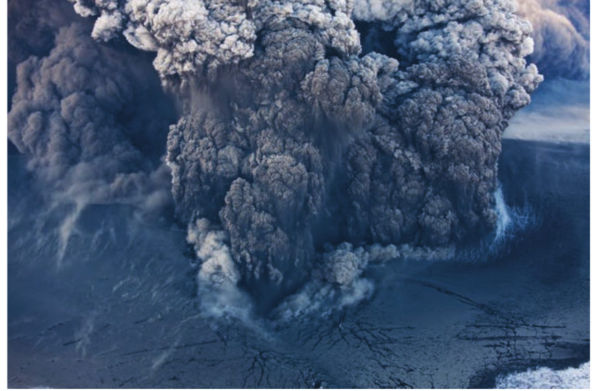
Real-World Case Study: Iceland 2010 Eruption
In 2010, a volcano in Iceland produced a massive eruption that created an enormous ash cloud. This eruption demonstrates the power of volcanic activity and shows how volcanoes can affect areas far from the eruption site. The ash cloud disrupted air travel across Europe for several weeks.
Key Facts:
- Iceland sits on the Mid-Atlantic Ridge
- Located where North American and Eurasian plates move apart
- Makes Iceland one of the most volcanically active places on Earth
Earthquake damage: Christchurch, New Zealand 2011
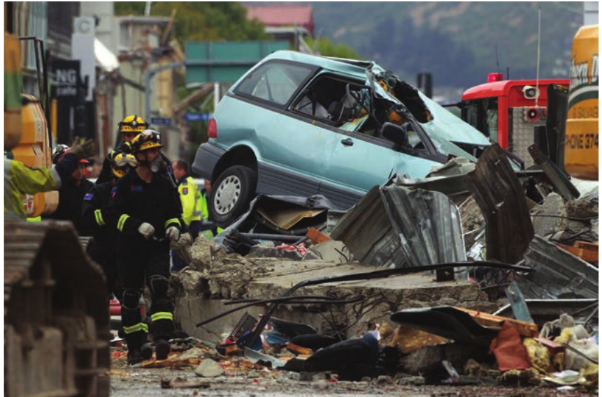
Real-World Case Study: Christchurch Earthquake 2011
In February 2011, a powerful earthquake struck the city of Christchurch in New Zealand, causing serious damage and loss of life. The image shows the devastating impact earthquakes can have on urban areas, with emergency responders working among collapsed buildings and damaged vehicles.
Key Facts:
- New Zealand sits near the boundary between Australian and Pacific plates
- Transform plate boundary runs very close to Christchurch
- Makes the region particularly vulnerable to earthquake damage
Why understanding these zones matters
Studying volcanic and earthquake zones helps us:
- Predict risk areas - knowing where geological hazards are most likely to occur
- Plan safer communities - building codes and emergency procedures can be adapted for high-risk zones
- Prepare for disasters - early warning systems and evacuation plans save lives
- Understand Earth's processes - these zones teach us how our planet works
For countries like South Africa, which sits in a relatively stable part of the African plate, understanding global patterns helps us appreciate why we experience fewer earthquakes and volcanic eruptions compared to countries on active plate boundaries.
Remember!
Key Points to Remember:
- Volcanic and earthquake zones are areas where tectonic activity has occurred recently
- Global patterns show these zones follow specific belts around the world, not random locations
- The Pacific Ring of Fire is the most active zone, containing most of the world's earthquakes and volcanoes
- Plate boundaries control where geological activity occurs - most earthquakes and eruptions happen where tectonic plates meet
- Real examples like Iceland's 2010 eruption and New Zealand's 2011 earthquake show the serious impacts these natural hazards can have on people and communities