Moisture in the Atmosphere (Grade 10 NSC Matric Geography): Revision Notes
Forms of Precipitation
What is precipitation?
Precipitation includes any form of moisture that falls from clouds to reach the ground. This covers liquid water like rain drops, solid ice forms like hail and snow, and moisture that condenses directly onto Earth's surface like dew and frost. Understanding precipitation is crucial because it determines water availability for all living things and shapes different climate patterns around the world.
Precipitation is one of the most important processes in the water cycle, directly affecting agriculture, water supply, weather patterns, and ecosystems worldwide. Without precipitation, life on Earth as we know it would not exist.
The process begins when tiny water droplets in clouds grow large enough to overcome air resistance and fall to Earth. This happens through coalescence - when droplets bump into each other and stick together in the turbulent air movement within clouds.
Rain
Rain forms when water droplets in clouds collide and join together through coalescence. The more turbulent the air movement, the bigger these droplets become. When they grow heavy enough that air currents cannot keep them suspended, they fall as rain.
Raindrop Size Comparison:
- Drizzle: Less than mm diameter - barely noticeable
- Average raindrop: About mm diameter - typical rainfall
- Large raindrops: Up to mm diameter - heavy downpours
- Unstable droplets: Larger than mm - break apart while falling
An average raindrop measures about 2 mm in diameter, but they can reach up to 9 mm across. Very light rain with droplets smaller than 0.5 mm is called drizzle. If droplets grow larger than 9 mm, they become unstable and break apart while falling.
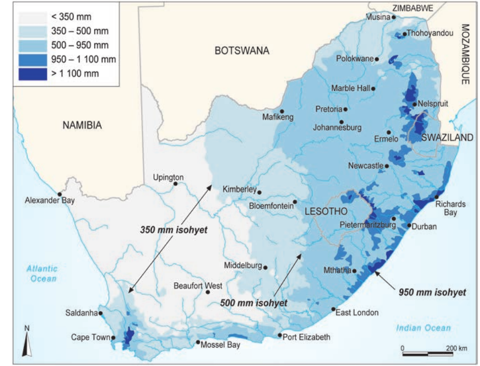
Representing rainfall on maps
Rainfall patterns can be shown on maps in two main ways:
- Colour coding: Different shades of blue represent varying amounts of annual rainfall, with darker blues indicating higher rainfall
- Isohyets: These are lines connecting places with equal rainfall amounts, similar to contour lines on a topographic map
Understanding Isohyets: Think of isohyets like contour lines on a topographic map, but instead of showing elevation, they show rainfall amounts. Areas between closely spaced isohyets have rapidly changing rainfall patterns, while widely spaced isohyets indicate gradual rainfall changes across the region.
Types of rain formation
Rain occurs when something in nature forces air to rise, cool, and form clouds. This natural mechanism is called a trigger action. There are three main types of rain based on what causes the air to rise initially.
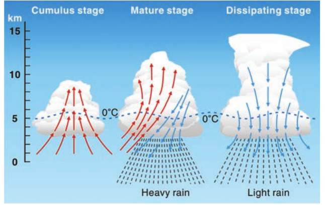
Convectional rain
Convectional rain creates thunderstorms. During hot summer days, particularly in inland South Africa, the land surface heats up intensely. This heated land warms the air above it, causing the air to rise and form convection currents.
The formation process follows distinct stages:
Cumulus stage: Hot air rises rapidly, forming growing cumulus clouds that can reach over 7 km in height.
Mature stage: The cloud becomes a towering cumulonimbus, with both upward and downward air movements occurring simultaneously. The friction between these opposing air currents creates electrical charges, leading to lightning.
Dissipating stage: When hailstones and large water droplets become too heavy for the air currents to support, they fall rapidly. This creates strong downdrafts that eventually weaken the storm.
Thunderstorm Safety: Convectional thunderstorms can develop rapidly and produce dangerous lightning, strong winds, and large hailstones. They typically occur during summer afternoons and evenings, lasting about 30 minutes but can range from 5 minutes to several hours.
Thunderstorms typically last about 30 minutes but can be as brief as 5 minutes or extend for several hours. In South Africa, convectional rain commonly occurs during summer afternoons and evenings inland.
Orographic rain (relief rain)
Mountains act as barriers that force moist air to rise, creating orographic rain. When moist air from oceans encounters mountain ranges, it must rise up the slopes. As it rises, the air cools and water vapour condenses to form clouds and precipitation.
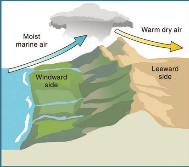
This process creates distinct climate zones on either side of mountains:
Windward side: The side facing the ocean where wind first strikes receives heavy rainfall as moist air is forced upward and cools.
Leeward side: The opposite side of the mountain experiences much drier conditions because most moisture has already fallen on the windward side. This creates a rain shadow - an area of low rainfall.
Rain Shadow Effect in Action:
Step 1: Moist ocean air approaches mountain range
Step 2: Air rises up windward slope, cooling and condensing
Step 3: Heavy rainfall occurs on windward side
Step 4: Dry air descends leeward side, warming and absorbing moisture
Result: Windward side receives heavy rain, leeward side becomes arid
The air that flows down the leeward side is warm and dry, having lost most of its moisture. This explains why some areas can be very dry despite being relatively close to the ocean.
In South Africa, orographic rain is common along the uKhahlamba-Drakensberg Mountains in KwaZulu-Natal and the Cape Fold Mountains in the Western and Southern Cape regions.
Frontal rain (cyclonic rain)
Frontal rain occurs when different air masses meet along boundaries called fronts. These fronts typically form between warm, moist air and cold, dry air masses.
When these different air masses encounter each other, the warmer air rises over the denser cold air because it is lighter. As the warm air rises, it cools and forms clouds that produce gentle, steady rainfall.
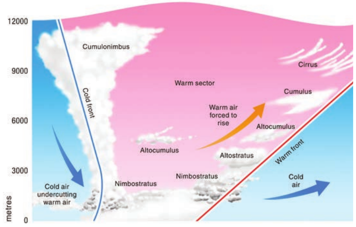
Characteristics of Frontal Rain: Unlike the sudden intensity of thunderstorms, frontal rain produces gentle, continuous rainfall that can persist for several days. This makes it particularly valuable for agriculture as it provides sustained moisture without causing erosion or flooding.
Frontal rain has several distinctive characteristics:
- It produces gentle, continuous rainfall rather than heavy downpours
- The rain can persist for several days
- Various cloud types form at different altitudes, including nimbostratus clouds that produce the actual rainfall
- Cold fronts can create steeper slopes, leading to more rapid air rise and sometimes cumulonimbus cloud formation
This type of rain is responsible for the winter rainfall that the Western Cape experiences when cold fronts move in from the Atlantic Ocean.
Hail
Hailstones are ice pellets that form specifically in strong thunderstorms with powerful convection currents. They develop when water droplets get caught in the intense up-and-down air movements within cumulonimbus clouds.
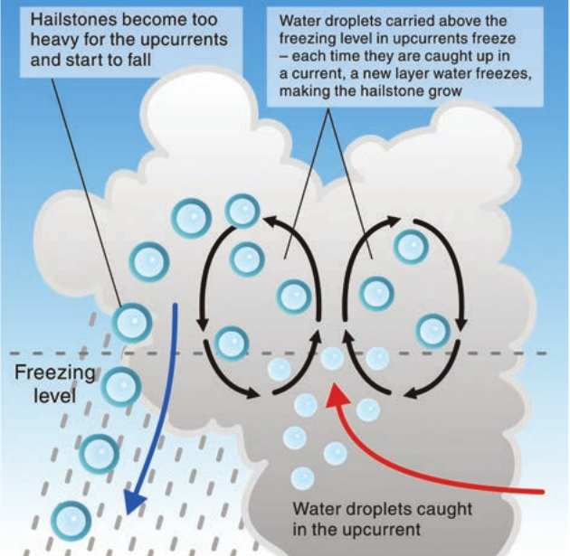
The formation process works like this:
- Strong updrafts carry water droplets high above the freezing level in the cloud
- These droplets freeze into small ice pellets
- Downdrafts carry them back down where they collect more water
- Updrafts carry them up again where this new water layer freezes
- This cycle repeats multiple times, creating layers of ice like an onion
Hail Damage Potential: The average hailstone reaching the ground measures 8-10 mm across, but violent thunderstorms can produce much larger hailstones that cause significant damage to crops, vehicles, and property. The repeated freezing cycles create dense, hard ice that can be destructive when falling at high speeds.
When hailstones finally become too heavy for even the strongest updrafts to carry, they fall to the ground.
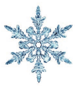
Snow
Snow requires temperatures below freezing point () to form. This is why snow typically occurs closer to the poles or at high altitudes where temperatures remain cold enough.
Snow forms through sublimation - a process where water vapour changes directly into ice crystals without first becoming liquid water. When these ice crystals float in clouds, additional water vapour freezes onto them, forming the beautiful six-sided snow crystals we observe.
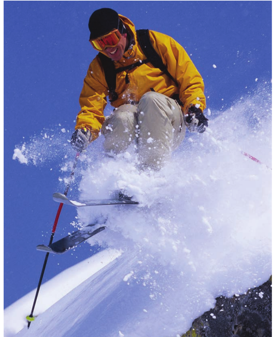
Snow in South Africa: In South Africa's relatively warm climate, natural snow is rare and typically only occurs on high mountain peaks during winter cold spells. However, when it does snow, it usually melts within a few days. Some areas, like Tiffindell in the Eastern Cape, occasionally receive enough snow to support skiing activities.
The snow crystals grow larger by colliding with other crystals or through further sublimation until they become heavy enough to fall as snowflakes.
Dew
Dew consists of small water droplets that form on grass, plants, and other surfaces during cool mornings. You might have noticed these sparkling water beads covering lawns and spider webs on certain mornings.

Dew formation follows this process:
- During night-time, land surfaces lose heat through radiation cooling
- The coldest temperatures typically occur just before sunrise
- Cold land surfaces cool the air directly above them
- When air temperature drops below the dew point, water vapour condenses directly onto surfaces as tiny droplets
Seasonal Dew Patterns:
Spring and Autumn: Most common dew formation - nighttime temperatures frequently drop below dew point with sufficient water vapour present
Summer: Less dew formation - even coolest nighttime temperatures often remain above dew point
Winter: Frost formation instead of dew - temperatures drop below
Frost
Frost forms through a similar process to dew but occurs when the dew point temperature drops below . Instead of liquid water droplets forming, water vapour sublimates directly into ice crystals on surfaces.
The key difference is temperature: while dew forms liquid droplets when surfaces cool below the dew point, frost creates ice crystals when surfaces cool below freezing point.

Frost and Agriculture: Frost can damage or kill vegetation, particularly plants that are not adapted to freezing conditions. This is why frost warnings are important for farmers and gardeners who need to protect sensitive crops and plants.
Key Points to Remember:
-
Five main precipitation forms: rain, hail, snow, dew, and frost - all resulting from water vapour changing state in the atmosphere
-
Three rain formation types: Convectional (thunderstorms from surface heating), orographic (mountains forcing air upward), and frontal (different air masses meeting)
-
Mountain rain shadow effect: Windward side receives heavy rainfall while leeward side experiences dry conditions due to descending warm, dry air
-
Temperature determines precipitation type: Above produces rain or dew, while below creates snow, hail, or frost
-
Trigger actions are essential: Something must force air to rise and cool for precipitation to occur - surface heating, mountains, or colliding air masses