Observation (Grade 11 NSC Matric Geography): Revision Notes
Observation
When conducting fieldwork for your geography research, making careful observations is essential for collecting reliable and valid data. There are several effective methods you can use to gather information during your fieldwork investigation: sketch maps, photographs with photo-sketches, and questionnaires. Each technique has specific advantages and guidelines that will help you collect the best possible data for your research.
What is observation in fieldwork?
Observation in fieldwork involves systematically recording what you see, hear, and experience at your research location. This data collection must be planned carefully to ensure your findings are accurate and useful for your investigation. The three main observation techniques each serve different purposes and can be used together to create a comprehensive picture of your study area.
The key to successful fieldwork observation is preparation. Before heading to your study location, decide which observation methods will best help you answer your research questions and gather the equipment you'll need.
1. Sketch maps
A sketch map is a simplified drawing that shows only the most important features relevant to your fieldwork investigation. Unlike detailed maps, sketch maps focus specifically on what you need to study, making them powerful tools for geographical research.
Creating effective sketch maps
When drawing a sketch map in the field, follow these essential guidelines to ensure your map is clear and useful:
-
Keep your map simple - Only include features that are directly relevant to your research question. Avoid cluttering your sketch with unnecessary details that might confuse your analysis later.
-
Draw a grid to help position key features - This helps you place elements accurately and maintains proper proportions in your sketch.
-
Draw in the main physical and human features - Include landforms, vegetation, buildings, roads, and other important elements that relate to your investigation.
-
Use colours and add a key if needed - Different colours help distinguish between feature types, and a clear legend ensures others can understand your map.
-
Give your map a suitable title - The title should clearly indicate what area you've mapped and why.
Remember that sketch maps are not meant to be perfectly accurate drawings. Their purpose is to clearly show the relationships between geographical features that matter for your research. Focus on clarity over artistic perfection.
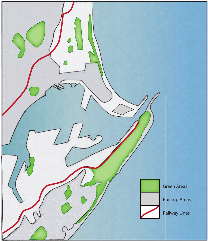
The sketch map above demonstrates these principles effectively, showing Durban harbour with clear colour coding for different land uses, a comprehensive legend, and focus on the most relevant features for studying this coastal urban area.
2. Photographs and photo-sketches
Taking photographs is an excellent way to record what places actually look like during your fieldwork. However, photographs often contain too much information, making it difficult to focus on the specific features you're studying. This is where photo-sketches become valuable tools.
The advantage of photo-sketches
A well-annotated photo-sketch solves the problem of information overload in regular photographs. You don't need artistic skills to create useful photo-sketches. Simply use a grid overlay on your photograph to help you create a simplified sketch version, or even trace over your photo using tracing paper.
Photo-sketch Technique
Place a transparent grid over your photograph or use tracing paper to create your sketch. This method helps you maintain accurate proportions while simplifying the image to show only the geographical features relevant to your study.
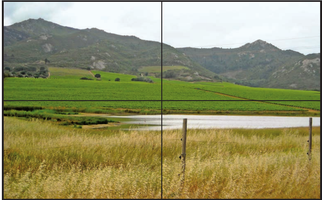
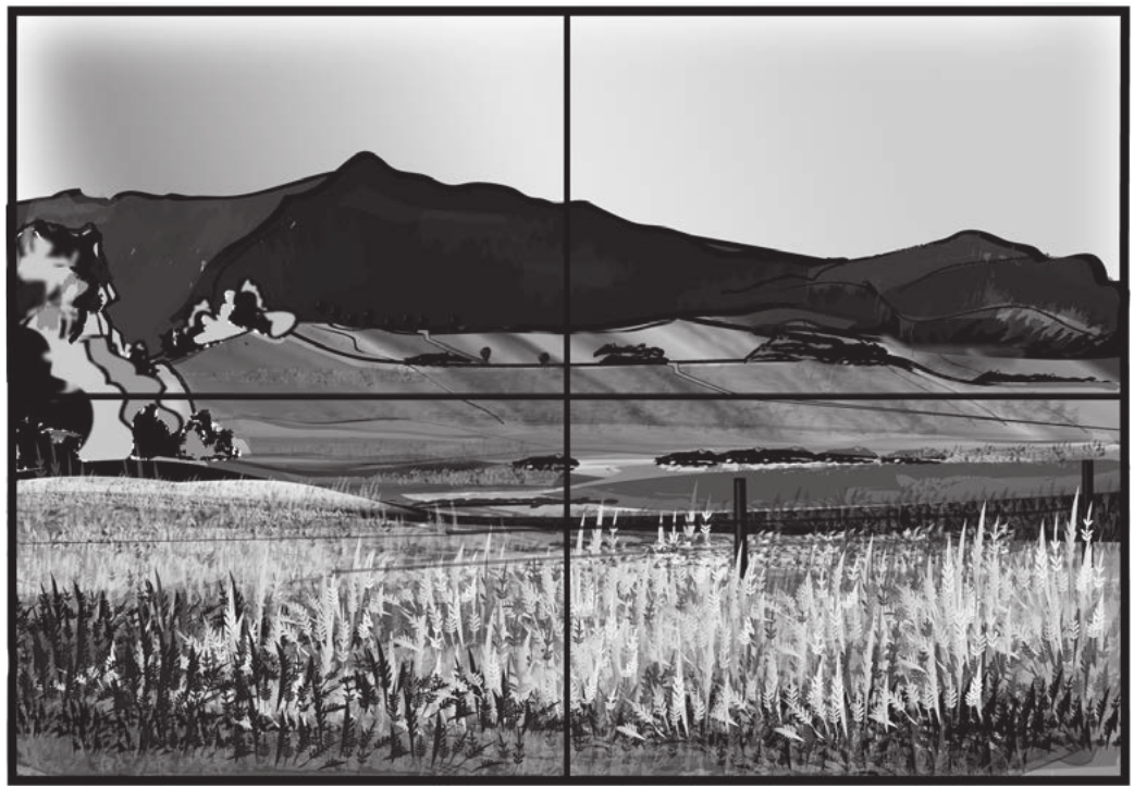
The examples above show how a photograph of Paardeberg can be transformed into a clearer photo-sketch. The original photograph contains lots of detail, whilst the sketch version highlights the key geographical features more clearly. Remember to always note the date, time, and location where your photograph was taken for your research records.
3. Questionnaires
Questionnaires are valuable tools for collecting information directly from people about your research topic. A well-designed questionnaire can provide insights that observation alone cannot give you. However, successful questionnaires require careful planning to ensure you gather reliable and useful data.
Planning your questionnaire
Before creating your questionnaire, consider how the information you collect will be used in your research. Keep your questions focused on your investigation topic, and make sure the people you survey can easily understand what you're asking them.
Avoiding Common Questionnaire Mistakes
Many students create questionnaires that are too long, ask confusing questions, or fail to consider how responses will be analyzed. Always test your questionnaire with friends or family before using it in the field to identify potential problems.
Features of an effective questionnaire
A good questionnaire should include these important elements:
-
Start with basic information that can be filled in easily, such as the date, place, and time of your survey.
-
Include a clear introduction explaining who you are and what research you're conducting. This helps people understand why you're asking questions.
-
Use a clipboard and attach a pencil to make the process professional and convenient for both you and the people you're surveying.
-
Begin with easy opening questions that make people feel comfortable participating in your survey.
-
Maintain anonymity when possible - People are more likely to give honest answers if they know their responses are anonymous. Avoid asking people to write down their names.
-
Prepare separate questionnaires for each person you survey to keep responses organised and confidential.
-
Design questions with tick-boxes rather than requiring long written answers. This makes your questionnaire quicker to complete and easier to analyse later.
-
Include space for additional comments by providing an "other" option after lists of possible answers. This captures information you might not have anticipated.
-
Avoid embarrassing or discriminatory questions about personal topics like age, income, or gender unless absolutely necessary for your research.
-
Thank participants at the end of your questionnaire to show appreciation for their time and cooperation.
-
Present your questionnaire professionally with clear layout, neat handwriting or typing, and organised structure.
Tips for successful questionnaire use
Choose appropriate locations and times for conducting your surveys. Make sure you approach people politely and respect their right to decline participation. Always explain your research clearly and be prepared to answer questions about how you'll use the information collected.
Sample Questionnaire Opening
"Good morning! My name is [Your name] and I'm a Grade 11 student conducting research about public transport use in our town center. Would you be willing to spend 3 minutes answering some questions? Your responses will be completely anonymous and will help with my geography project."
This introduction is polite, explains the purpose clearly, and tells people how long it will take.
Key Points to Remember:
-
Sketch maps should be simple and focused - only include features relevant to your research question, and always include a clear title and legend.
-
Photo-sketches overcome information overload - they help you focus on key geographical features that might get lost in detailed photographs.
-
Questionnaire success depends on careful planning - think about your research needs, keep questions simple, and make the experience comfortable for participants.
-
All observation methods work best when combined - using sketch maps, photo-sketches, and questionnaires together gives you a comprehensive understanding of your study area.
-
Professional presentation matters - well-organised data collection tools produce better quality information and encourage people to participate in your research.