Relative Position (Grade 11 NSC Matric Geography): Revision Notes
Relative Position
Understanding relative position is essential for navigation and mapwork. This involves describing where one place is located in relation to another using direction and bearing measurements.
What is relative position?
Relative position describes how to find one location by using another location as a reference point. Instead of giving exact coordinates, you explain the direction and distance relationship between two places. This is particularly useful for navigation, whether you're hiking, sailing, or reading maps.
The key advantage of relative position is that it doesn't require precise coordinate systems - you can navigate effectively by understanding the relationship between locations.
Direction
Direction gives us a general description of where one place is located compared to another. When we talk about direction, we use compass points to be more precise than simply saying "over there" or "that way".
The 16 compass points
A compass has sixteen main points that help us describe direction accurately. The four most important are the cardinal directions:
- North (N) - points towards the North Pole
- South (S) - points towards the South Pole
- East (E) - points towards where the sun rises
- West (W) - points towards where the sun sets
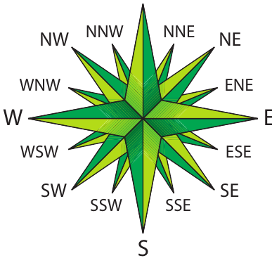
Between these cardinal points, we also have intercardinal directions (like Northeast, Southwest) and even more precise half-wind directions (like North-Northeast). These 16 points allow us to describe direction much more accurately than using just the four main compass points.
When do we use direction?
Direction is commonly used when:
- Describing wind patterns and weather systems
- Explaining the flow of rivers and ocean currents
- Giving general navigation instructions
- Describing the relative position of geographical features
Remember that direction gives us a general idea of position, but it's not as precise as bearing measurements.
Bearing
When we need to be very precise about position, we use bearing measurements. A bearing tells us the exact angle between our starting point and our destination.
True bearing
True bearing is the most accurate way to measure position. It tells us the exact angle measured clockwise from true north to reach our destination.
True north points directly towards the Geographic North Pole - the actual "top" of the Earth where all longitude lines meet. This never changes and is the same everywhere on Earth.
The three-step method for calculating true bearing
Worked Example: Calculating True Bearing
To find a true bearing using a topographic map, follow these steps:
Step 1: Draw a north-south line through your starting point
This line should run parallel to the longitude lines on your map and point towards true north.
Step 2: Draw a straight line connecting your starting point to your destination
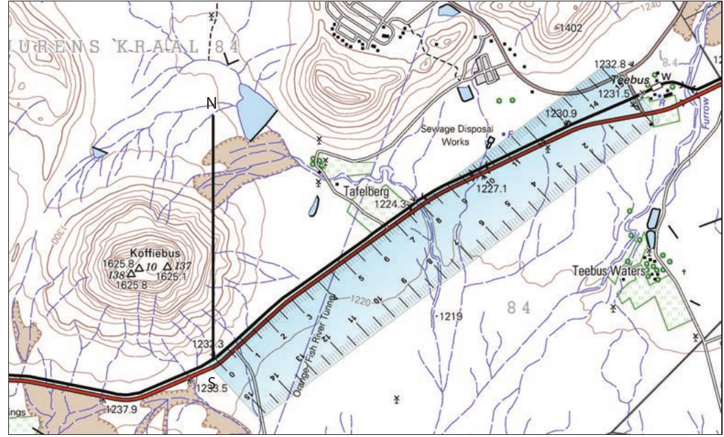
This creates the line along which you need to measure the angle.
Step 3: Measure the angle clockwise from true north
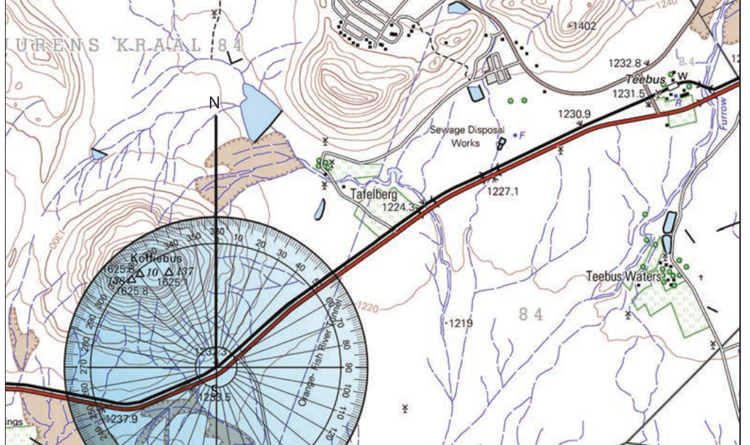
Using a protractor, measure the angle from your north-south line to your destination line, always measuring in the clockwise direction.
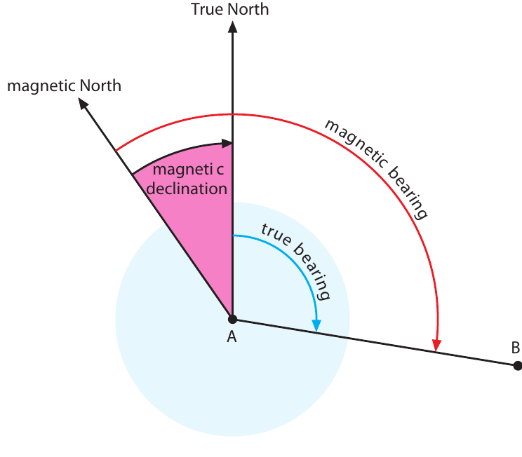
Magnetic bearing
While true bearing is more accurate, magnetic bearing is what you actually see when using a compass. This measures the angle clockwise from magnetic north instead of true north.
Magnetic north is where a compass needle naturally points. This happens because Earth has a magnetic field, similar to a giant magnet, with a Magnetic North Pole. However, this magnetic pole is not in the same place as the Geographic North Pole.
Understanding magnetic declination
The difference between true north and magnetic north creates what we call magnetic declination. This is the angle between these two different "norths" when measured from any point on Earth's surface.
Magnetic declination is important because:
- It varies depending on where you are on Earth
- It changes over time as the Magnetic North Pole moves
- It affects all compass readings
- You need to know it to convert between true and magnetic bearings
Why magnetic declination changes
Earth's magnetic field is created by the movement of liquid iron in the planet's core. Because this liquid is constantly moving, the magnetic field - and therefore the Magnetic North Pole - slowly shifts position over time.
The Magnetic North Pole can move several kilometres each year. Scientists track these changes and update the magnetic declination information on topographic maps regularly.
Finding magnetic declination information
When you look at a topographic map, you'll find magnetic declination information at the bottom. This tells you:
- The magnetic declination for that area when the map was made
- How much the declination changes each year
- Which organisation provided this information
For example, a map might show: "Mean magnetic declination 23°53' West of True North (July 2002). Mean annual change 6' Westwards (2000-2005)."
Calculating current magnetic declination
Maps aren't always current, so you may need to calculate the magnetic declination for today's date.
Worked Example: Updating Magnetic Declination
Use this three-step method:
Step 1: Calculate the number of years since the map's starting date
- Subtract the starting year from the current year
- Example: If the map is from 2002 and it's now 2012, that's 10 years
Step 2: Calculate the total change in declination
- Multiply the annual change by the number of years
- Example: 6 minutes westward × 10 years = 60 minutes (or 1°) westward
Step 3: Apply the change to the original declination
- Add the change if the migration is towards the east
- Subtract the change if the migration is towards the west
- Example: 23°53' west - 1° = 22°53' west in 2012
Converting between bearings
| Location | True Bearing | Magnetic Bearing |
|---|---|---|
| Marine beacon in E7 | ||
| Whaling station in H6 | ||
| Post office in J1 |
Conversion Rules:
To convert from true bearing to magnetic bearing:
- Subtract the magnetic declination if it's westward
- Add the magnetic declination if it's eastward
To convert from magnetic bearing to true bearing:
- Add the magnetic declination if it's westward
- Subtract the magnetic declination if it's eastward
Practical applications
Understanding relative position helps you:
- Navigate using maps and compasses
- Give accurate directions to others
- Understand weather patterns and their directions
- Work with GPS systems more effectively
- Interpret topographic maps correctly
When working with bearings, always remember to check whether you're using true or magnetic measurements, and make sure you know the current magnetic declination for your area.
Key Points to Remember:
- Direction uses compass points to give general position relationships between places
- True bearing measures the exact angle clockwise from true north (Geographic North Pole)
- Magnetic bearing measures the exact angle clockwise from magnetic north (where compass needles point)
- Magnetic declination is the difference between true north and magnetic north, and it changes over time and location
- Always use the three-step method for calculating bearings: draw north-south line, connect the points, measure clockwise
- Convert between true and magnetic bearings by adding or subtracting the magnetic declination correctly