Topographic Maps (Grade 11 NSC Matric Geography): Revision Notes
Contours and Landforms
What are contours?
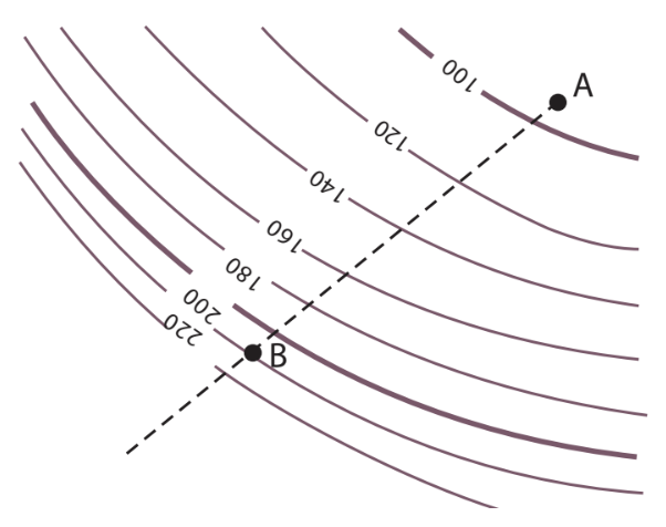
Contours represent imaginary lines that connect points at exactly the same height above sea level. Think of them as the "footprint" that water would leave if sea level rose to different heights across the landscape. These lines are essential tools for understanding the shape and elevation of land on topographic maps.
Key characteristics of contours:
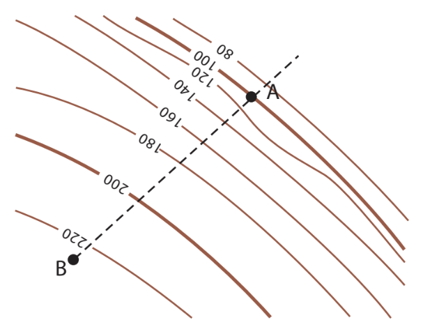
- Appearance: Contours appear as brown lines on topographic maps
- Contour interval: The change in height between each contour line, typically 20 metres on standard topographic maps
- Index contours: Lines representing multiples of hundreds (like 100m, 200m, 300m) appear as slightly darker brown lines
- Purpose: They help us identify gradient and landform features such as hills, valleys, and plains
Understanding contours through practical examples
To truly grasp how contours work, imagine drawing lines around your clenched fist at different heights. This demonstrates how three-dimensional landforms are represented on flat maps.
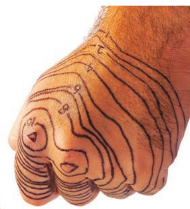
Practical Demonstration: The Hand Method
The hand demonstration shows how contour lines follow the shape of curved surfaces. When you open your hand and place it flat, you can see how the three-dimensional knuckle range becomes a two-dimensional contour map. This exercise helps you understand that contour lines represent the actual shape of terrain features.
Real-world example: Paarl Rock
Paarl Rock in South Africa provides an excellent example of how contours represent actual landscape features. The massive granite formations create distinctive patterns on topographic maps.
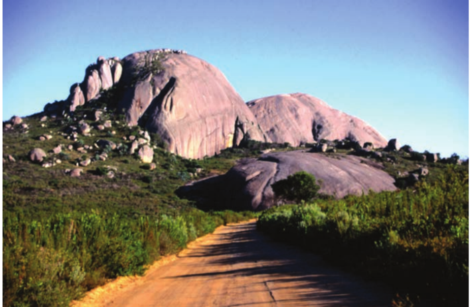
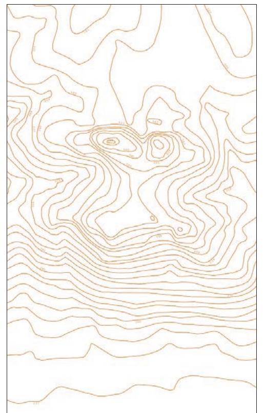
Case Study: Paarl Rock Contour Analysis
By comparing the photograph with its corresponding contour map, you can see how the rounded granite domes create concentric circular and oval patterns. The closely spaced contours indicate steep slopes, while wider spacing shows gentler gradients.
Slope types and their contour patterns
Understanding different slope types is crucial for interpreting topographic maps accurately.
Convex slopes
Convex slopes curve outwards like the outside of a circle. On contour maps, these slopes show contours that are closely spaced at lower elevations and gradually become further apart towards the top. This pattern indicates that the slope becomes less steep as you climb higher.
Concave slopes
Concave slopes curve inwards like the inside of a bowl. Their contour patterns show lines that are widely spaced at the bottom and become progressively closer together towards the top. This means the slope becomes steeper as you ascend.
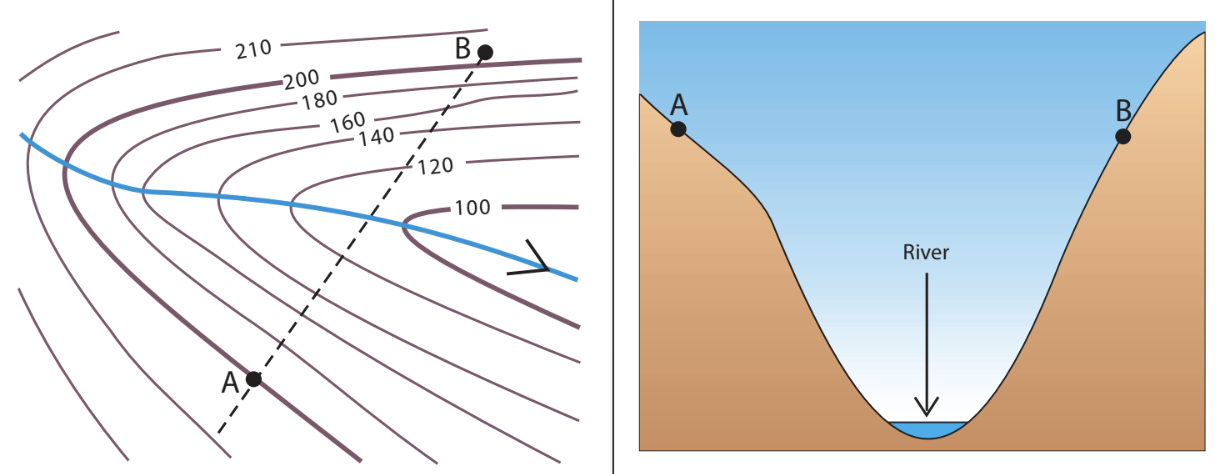
Valleys
Valleys have a distinctive V-shaped contour pattern where the contour lines point uphill (towards higher elevations). Rivers typically flow through valleys, and the V-shape always points upstream towards the source of the water.
Spurs
Spurs are the opposite of valleys - they represent ridges of land that extend outward from hills or mountains. Their contour lines form V-shapes that point downhill (towards lower elevations). Spurs are the higher-lying areas between valleys.
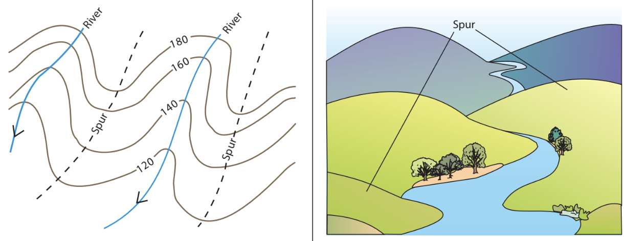
Critical Pattern Recognition:
- Valley contours point uphill - V-shapes point towards higher elevations
- Spur contours point downhill - V-shapes point towards lower elevations
- Remember: This is the opposite of what you might intuitively expect!
Highland features
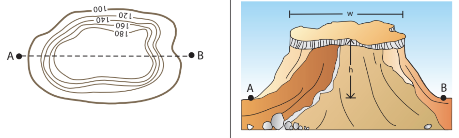
Mesa
A mesa is a flat-topped hill that is wider than it is tall. The Spanish word "mesa" means "table," which perfectly describes its appearance. On contour maps, mesas show as oval or circular patterns with closely spaced contours around the edges and a flat area in the centre represented by widely spaced contours.
Butte
A butte is similar to a mesa but smaller - it's a flat-topped hill that is higher than it is wide. Think of it as a tower-like formation. Buttes appear on contour maps as more circular patterns compared to the elongated shapes of mesas.
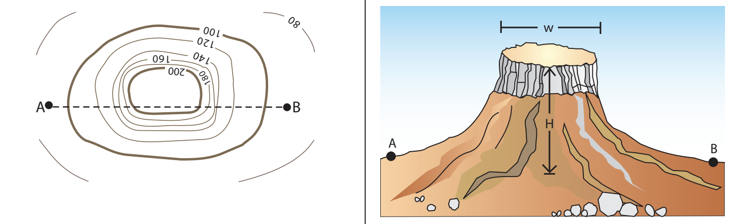
Memory Aid for Highland Features:
- Mesa = Table (wider than tall, like a dining table)
- Butte = Tower (taller than wide, like a watchtower)
Low-lying features and transport routes
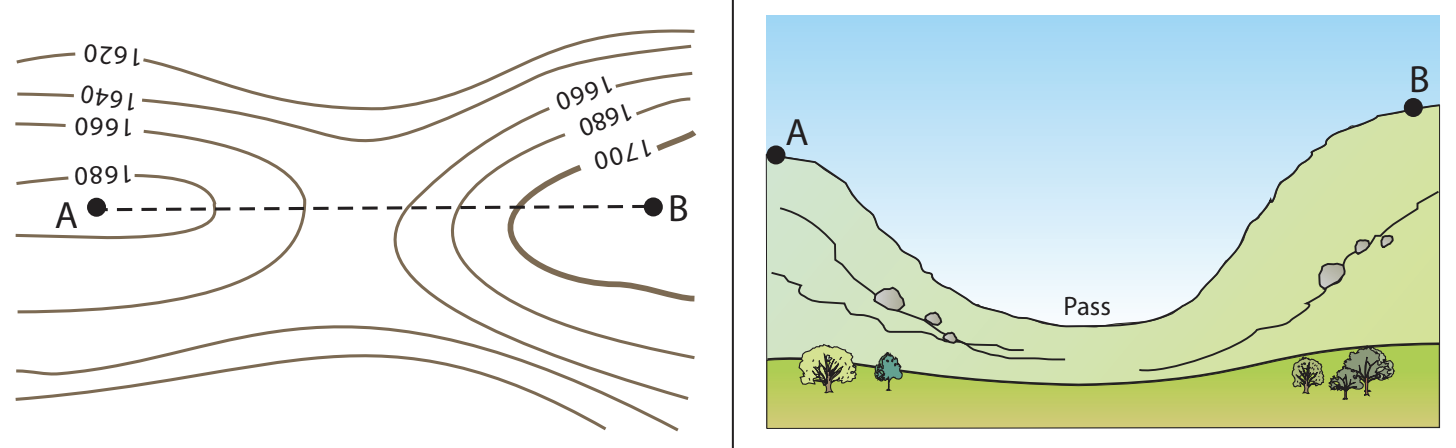
Pass
A pass represents a lower-lying dip between two pieces of highland. These natural corridors through mountainous terrain are where transport routes like roads and railways are typically constructed. On contour maps, passes appear as saddle-shaped patterns where contour lines curve around from both sides.
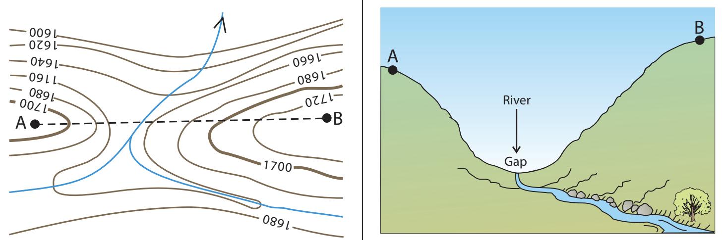
Poort or gap
A poort (also called a gap) is a complete break between two pieces of highland. Unlike passes, poorts often contain rivers flowing through them. These features appear on contour maps as clear breaks in the contour pattern, often with blue lines indicating water features.
Transport Geography Connection:
Passes and poorts are crucial for human settlement and movement patterns. Throughout history, these natural corridors have determined trade routes, railway lines, and major highways. The famous mountain passes of the world - like the Khyber Pass or Brenner Pass - demonstrate how geography shapes human activity.
Reading contour patterns effectively
When interpreting topographic maps, understanding these essential principles will help you visualize the landscape:
Essential Contour Reading Rules:
- Closely spaced contours = steep slopes
- Widely spaced contours = gentle slopes
- Circular patterns = hills or peaks
- V-shapes pointing uphill = valleys
- V-shapes pointing downhill = spurs
- Saddle shapes = passes
- Breaks in patterns = gaps or poorts
Understanding these patterns allows you to visualise the three-dimensional landscape from a flat map and identify suitable routes for hiking, road construction, and other land use activities.
Key Points to Remember:
-
Contours connect points of equal elevation - they show the shape of land by joining areas at the same height above sea level
-
Contour spacing indicates steepness - close lines mean steep slopes, while widely spaced lines show gentle gradients
-
Different landforms have distinctive patterns - valleys point uphill, spurs point downhill, while mesas and buttes show circular formations
-
Transport routes follow natural corridors - passes and gaps provide easier pathways through highland areas
-
The contour interval is typically metres on standard topographic maps, with index contours marked in darker brown at -metre intervals