Inclined Rock Strata – Characteristics, Processes, and Utilisation (Grade 11 NSC Matric Geography): Revision Notes
Inclined Rock Strata – Characteristics, Processes, and Utilisation
Introduction to inclined rock strata
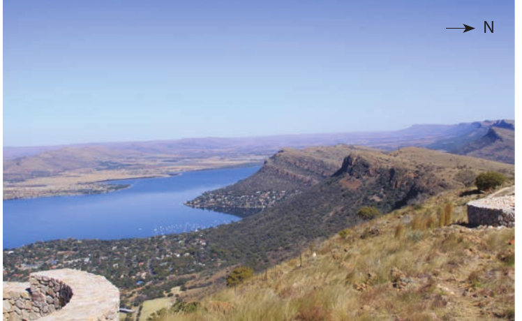
When sedimentary rocks are tilted or inclined rather than lying flat, they create distinctive asymmetrical landforms across the landscape. These tilted rock layers result from tectonic forces that have folded and deformed the Earth's crust over millions of years. As these inclined rock formations are exposed to weathering and erosion, they develop characteristic ridge and valley patterns that differ significantly from horizontal rock structures.
The key to understanding these landscapes lies in recognizing that different rock layers have varying resistance to erosion. This concept of differential erosion is fundamental to explaining why some areas become ridges while others form valleys.
When sedimentary rocks are tilted, the more resistant layers create ridges while the softer layers form valleys between them. This differential erosion process creates the asymmetrical ridge patterns that define inclined rock strata topography.
Basic characteristics of asymmetrical landforms
Understanding scarp slopes and dip slopes
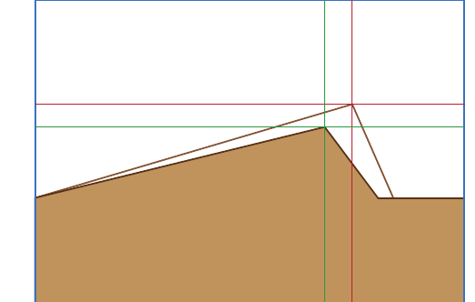
Inclined rock strata create ridges that have two distinctly different sides, making them asymmetrical in cross-section. These ridges possess a gentle slope on one side and a much steeper slope on the other side.
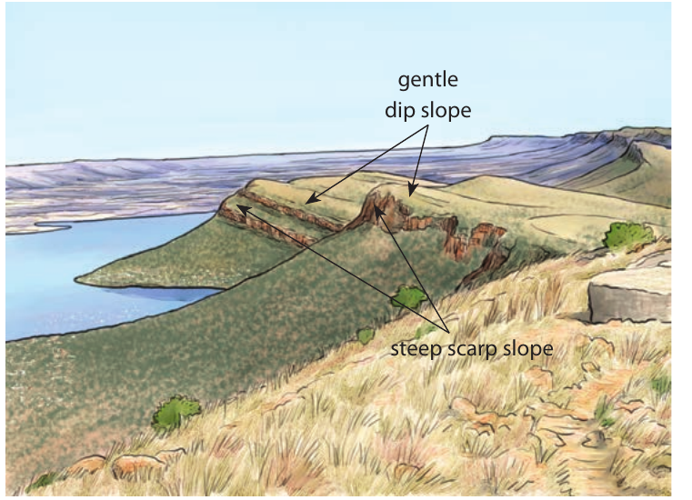
The steep side of these asymmetrical ridges is called the scarp slope. This steep face develops because it cuts across the tilted rock layers, exposing the resistant rock edges to direct erosional forces. The scarp slope typically faces the direction opposite to the rock layer inclination.
The gentle side is known as the dip slope, which follows the natural inclination of the rock layers. Since this slope aligns with the rock structure, it experiences less severe erosion and maintains a more gradual gradient. The dip slope extends in the same direction as the rock layer inclination.
Remember the difference: Scarp = Steep (cuts across rock layers), Dip = Downward gentle (follows rock layer angle)
The asymmetrical nature
These landforms are described as asymmetrical because their two sides are not mirror images of each other. Unlike symmetrical hills or mountains, these ridges have distinctly different slope angles on each side. This asymmetry is the defining characteristic that helps geographers identify landscapes formed by inclined rock strata.
Types of homoclinal ridges
All asymmetrical ridges formed by inclined rock strata are collectively known as homoclinal ridges. However, these ridges are further classified based on the angle of rock inclination, which directly influences their appearance and steepness.
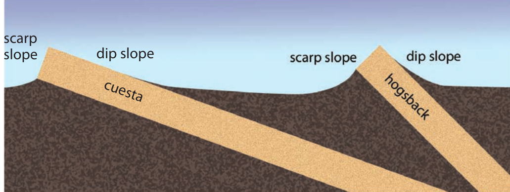
Cuestas
When rock layers are inclined at angles between and , the resulting asymmetrical ridges are called cuestas. Cuestas have a relatively gentle dip slope and a moderately steep scarp slope. The moderate inclination angle means that the difference between the scarp and dip slopes is noticeable but not extreme.
Hogsbacks
When rock layers are inclined at steeper angles between and , they form hogsbacks. These ridges have a much steeper dip slope compared to cuestas, and the scarp slope becomes even more pronounced. The steeper inclination creates a more dramatic contrast between the two sides of the ridge.
Classification Example: Identifying Ridge Types
Step 1: Measure the rock inclination angle
- If rock layers tilt at → This forms a cuesta
- If rock layers tilt at → This forms a hogsback
Step 2: Observe the landscape
- Cuestas: More gentle dip slopes, moderate contrast between sides
- Hogsbacks: Steeper overall profile, dramatic contrast between scarp and dip slopes
The name "hogsback" comes from the ridge's resemblance to the curved back of a pig when viewed from the side, with both slopes appearing relatively steep compared to the gentler profiles of cuestas.
Dynamic processes affecting homoclinal ridges
Homoclinal shifting
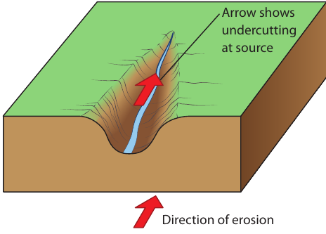
Over time, the position of ridges created by inclined rock strata can change due to ongoing erosional processes. The highest point of a homoclinal ridge, known as the watershed, serves as the dividing line that separates different river systems and drainage basins flowing in opposite directions.
However, this watershed position is not permanent. Rivers flowing down the steeper scarp slope have more energy than those flowing down the gentler dip slope. This energy difference means that streams on the scarp slope erode more rapidly and deeply into the landscape.
Headward erosion process
The increased erosional energy on the scarp slope leads to a process called headward erosion. This occurs when streams actively erode backward into their source areas, gradually extending their channels upstream.
Understanding Homoclinal Shifting Process:
The key mechanism is energy difference between slopes. Steeper scarp slopes create faster-flowing streams with greater erosive power, while gentler dip slopes produce slower streams with less erosive energy. This imbalance drives the entire shifting process.
As headward erosion continues, the streams on the scarp slope cut deeper valleys and gradually undercut the ridge at its source. This undercutting causes the ground to collapse and be removed by flowing water, making the streams longer over time. Eventually, this process shifts the watershed position toward the dip slope side of the ridge.
This entire process of watershed migration is called homoclinal shifting. Over geological time scales, homoclinal shifting can significantly alter the landscape, moving ridge crests and changing drainage patterns across the terrain.
Circular formations in inclined rock strata
Cuesta basins
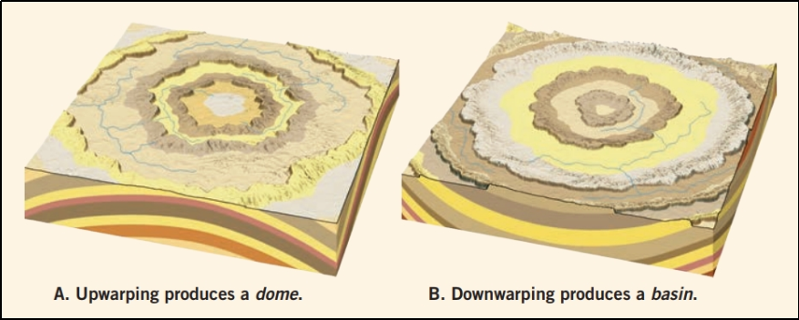
Not all inclined rock strata form straight ridges across the landscape. When sedimentary rocks have been folded or warped into a bowl-like shape, they create circular or oval ridge patterns known as cuesta basins.
In a cuesta basin, the rock layers have "sagged" or been depressed toward a central point, similar to how a flexible sheet might sag when weighted in the middle. When these circular rock structures are exposed at the Earth's surface, they create concentric rings of ridges and valleys.
The key characteristic of a cuesta basin is that the steep scarp slopes face outward away from the center, while the gentle dip slopes face inward toward the center of the basin. This arrangement creates a natural amphitheater-like landscape with the resistant rock layers forming protective ridges around a central depression.
Cuesta domes
The opposite situation occurs when internal crustal forces push sedimentary rocks upward, creating a dome-like structure. These formations are called cuesta domes and represent the inverse of cuesta basins.
In a cuesta dome, the rock layers have buckled upward, similar to how an arch or dome is constructed. When weathering and erosion expose these uplifted structures, they also create circular ridge patterns, but with a crucial difference in orientation.
Remember the Direction Rule:
- Cuesta Basin: Scarp slopes face OUTWARD from center (like a bowl)
- Cuesta Dome: Scarp slopes face INWARD toward center (like a mound)
This orientation difference is crucial for identifying these circular formations in the landscape.
The steep scarp slopes in a cuesta dome face inward toward the center of the dome, while the gentle dip slopes face outward away from the center. This creates a series of concentric ridges that become progressively higher toward the center of the dome structure.
Human utilisation of inclined rock strata landscapes
Settlement patterns and residential areas
Homoclinal ridges create unique challenges and opportunities for human settlement. These landscapes are generally characterized as fairly low ranges of hills, making them more accessible than high mountain regions. The gentle dip slopes and valleys between homoclinal ridges provide suitable areas for people to establish communities and develop agricultural activities.
However, the steep scarp slopes present significant challenges for development. These cliff-like faces are typically too steep and unstable for residential construction. Instead, settlements tend to concentrate on the gentler dip slopes or in the valleys between ridges, where the terrain is more manageable and safer for building.
At the base of scarp slopes, loose rock fragments accumulate in areas called talus slopes. These zones of fallen rock debris further limit development opportunities directly below cliff faces, as they represent areas of ongoing rockfall hazard.
Agricultural utilisation
The agricultural potential of homoclinal ridge landscapes varies significantly between different slope types. The gentle dip slopes of cuestas are particularly valuable for farming because their gradual incline is suitable for cultivation and the soil depth is often adequate for plowing and crop production.
In contrast, the steep scarp slopes are generally unsuitable for agriculture. These cliff faces cannot support farming activities due to their extreme gradients and the thin, rocky soils that typically develop on such steep terrain.
The valleys between homoclinal ridges often provide the most favorable conditions for intensive agriculture, as they tend to have deeper soils and better access to water resources.
Transportation challenges
Homoclinal ridges create significant obstacles for transportation infrastructure. The steep scarp slopes make it difficult or impossible to build roads that cross directly over ridges from one side to the other. Instead, transportation routes must often run parallel to the ridges, following the valleys between them or utilizing the gentler dip slopes.
When roads do need to cross homoclinal ridges, they typically seek out natural gaps or passes where the ridge height is minimized. This routing requirement can create longer, more circuituous routes between communities located on opposite sides of ridge systems.
Railway construction faces similar challenges, as trains require gentle gradients to operate efficiently. Like roads, railway lines often follow valley routes parallel to ridge systems rather than attempting direct crossings.
These transportation limitations can influence regional development patterns, as areas separated by homoclinal ridges may have reduced connectivity and slower economic integration compared to regions with more uniform terrain.
Key Points to Remember:
-
Inclined rock strata create asymmetrical ridges with a steep scarp slope on one side and a gentle dip slope on the other, unlike symmetrical hills formed by horizontal rock layers
-
Classification depends on inclination angle: cuestas form from rocks tilted -, while hogsbacks develop from rocks inclined -, with hogsbacks appearing steeper and more dramatic
-
Homoclinal shifting occurs over time as streams on the steeper scarp slope erode faster than those on the dip slope, gradually moving the watershed position through headward erosion processes
-
Circular patterns form from folded rocks: cuesta basins have scarp slopes facing outward from a central depression, while cuesta domes have scarp slopes facing inward toward an elevated center
-
Human utilisation focuses on gentler areas with settlements and agriculture favoring dip slopes and valleys, while transportation routes must navigate around steep scarp slopes that create natural barriers