The Plateau (Grade 12 NSC Matric Geography): Revision Notes
The Plateau
What is the South African plateau?
South Africa's landscape is dominated by a massive elevated landform called a plateau. A plateau is essentially a flat or gently undulating area of land that sits at a high altitude above sea level. Most of our country is positioned on this elevated platform, which significantly shapes our climate patterns.
The South African plateau is not a single uniform structure but rather a complex elevated region with varying elevations across different areas. This variation creates the diverse climate zones we observe throughout the country.
This plateau structure is not uniform across the country. Instead, it creates a varied landscape with different elevation levels that directly influence local temperatures and weather conditions.
How altitude affects temperature
One of the most important principles in understanding South Africa's climate is the relationship between altitude and temperature. As you move higher above sea level, temperatures become progressively cooler. This happens because air pressure decreases with altitude, causing the atmosphere to become thinner and less able to retain heat.
Fundamental Climate Principle: The higher you go, the cooler it gets. This altitude-temperature relationship is the key to understanding why different regions of South Africa experience such varied climatic conditions.
This temperature-altitude relationship is crucial for explaining why different parts of South Africa experience such varied climatic conditions, even when they're located at similar latitudes.
Temperature differences across regions
The plateau's influence creates distinct temperature patterns across South Africa's regions:
The Highveld regions (including Gauteng and the Free State) sit on the elevated plateau at high altitudes. Because of their elevated position, these areas experience cooler temperatures throughout the year compared to lower-lying regions.
The Lowveld areas (particularly in Mpumalanga) are located at much lower altitudes. Despite being relatively close to Highveld regions geographically, the Lowveld experiences significantly warmer temperatures due to its lower elevation.
Practical Temperature Comparison:
- Johannesburg (Highveld): Located at approximately 1,753m above sea level, experiences average temperatures of 16°C annually
- Nelspruit (Lowveld): Located at approximately 660m above sea level, experiences average temperatures of 21°C annually
This demonstrates a temperature difference of about 5°C due to the 1,000m difference in altitude.
This temperature contrast between high and low-lying areas creates diverse climate zones within relatively short distances, contributing to South Africa's rich variety of ecosystems and agricultural possibilities.
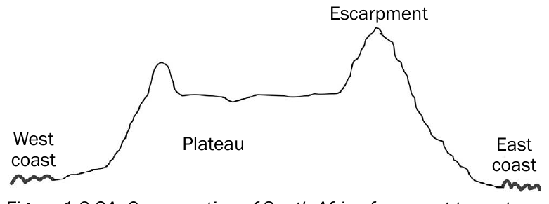
Understanding South Africa's cross-section
When we examine South Africa from west to east, we can see how the plateau creates a distinctive landscape profile. The cross-section reveals several key features:
- West coast: Lower-lying coastal areas
- Central plateau: The elevated flat interior region
- Eastern escarpment: A dramatic steep slope where the plateau drops down towards the coast
- East coast: Lower-lying coastal areas
The eastern escarpment is particularly dramatic, with some areas dropping over 1,000 metres in elevation within just a few kilometres. This creates one of the most significant climate boundaries in South Africa, where temperatures can vary dramatically over short distances.
This structure means that as you travel inland from either coast, you generally climb onto the plateau, experiencing cooler temperatures as you gain altitude. The eastern escarpment is particularly significant, creating one of the most dramatic elevation changes in the country.
Why this matters for South Africa's climate
The plateau's influence extends beyond just temperature differences. This elevated structure affects:
- Seasonal temperature variations: Higher areas experience greater temperature fluctuations between seasons
- Frost occurrence: Plateau regions are more prone to frost due to their altitude and inland position
- Agricultural patterns: Different crops thrive at different elevations due to temperature variations
- Settlement patterns: Human settlements have historically been influenced by these climate zones
Understanding the plateau's impact is essential for explaining why locations like Johannesburg (on the Highveld) and Nelspruit (in the Lowveld) can have such different climates despite both being inland locations. The altitude difference of over 1,000 metres between these cities creates fundamentally different climate conditions.
Understanding the plateau's impact helps explain why Johannesburg (on the Highveld) has a different climate from Nelspruit (in the Lowveld), despite both being inland locations.
Key Points to Remember:
- South Africa is mostly situated on an elevated plateau, which significantly influences our climate patterns
- Fundamental principle: Higher altitude always means cooler temperatures - this is a core concept in physical geography
- The Highveld regions (like Gauteng and Free State) are cooler due to their high elevation on the plateau
- The Lowveld areas (like parts of Mpumalanga) are warmer because they sit at lower altitudes
- The cross-section from west to east shows how the plateau creates South Africa's distinctive landscape profile with coastal areas, central plateau, and dramatic eastern escarpment
- This altitude variation creates diverse climate zones within short distances, contributing to South Africa's rich environmental diversity