Fluvial Geomorphology (Grade 12 NSC Matric Geography): Revision Notes
Groundwater
Introduction to groundwater
Groundwater forms a crucial part of the water cycle and plays an important role in South Africa's drainage systems. Understanding how groundwater forms and moves helps us comprehend the broader patterns of water flow across our landscape.
What is groundwater?
Groundwater refers to water that collects and remains stored below the Earth's surface. When rain falls onto the land, this water has two main pathways - it can either flow across the surface as runoff or soak down into the ground through a process called infiltration. The water that infiltrates becomes part of the groundwater system.
This underground water eventually contributes to river flow and supports vegetation during dry periods, making it essential for South Africa's water security.
The water cycle and groundwater formation
The formation of groundwater is directly linked to the water cycle. This continuous process involves several key stages that work together to create and maintain underground water supplies.
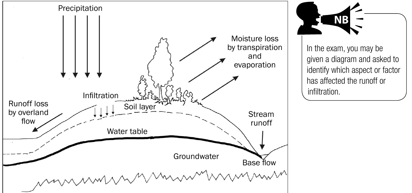
The diagram shows how precipitation falls from clouds and then follows different paths. Some water evaporates back into the atmosphere, some is taken up by plants through transpiration, and the remainder either becomes surface runoff or infiltrates into the ground to join the groundwater supply.
The water table represents the upper boundary of the groundwater zone - essentially the level below which the soil and rock are completely saturated with water. Above this line, spaces between soil particles contain both air and water, whilst below it, all spaces are filled with water.
Factors affecting groundwater formation
Three main factors determine whether precipitation will become surface runoff or infiltrate to form groundwater. These factors work together to influence the balance between water flowing over the surface and water soaking into the ground.
Understanding these three factors is crucial for predicting groundwater formation and managing water resources effectively. They work in combination - areas with favourable conditions for all three factors will have the highest rates of groundwater recharge.
Rock porosity
The type of rock and soil determines how easily water can pass through. Porous rocks and soils contain many small spaces and cracks that allow water to philtre through easily. Examples include sandstone and loose sandy soils. These materials promote greater infiltration and help build up groundwater supplies.
In contrast, non-porous rocks like granite or clay have few spaces for water to pass through. When rain falls on these surfaces, most water is forced to flow over the surface as runoff rather than soaking in.
Topography and slope gradient
The steepness of the landscape significantly affects how much time water has to infiltrate. On gentle slopes, water moves slowly across the surface, giving it more opportunity to soak into the ground. This leads to higher infiltration rates and better groundwater recharge.
On steep slopes, gravity causes water to flow rapidly downhill, leaving little time for infiltration to occur. Most precipitation on steep terrain becomes surface runoff, contributing less to groundwater formation.
Vegetation coverage
Plants play a vital role in slowing down surface water flow and promoting infiltration. Dense vegetation acts like a natural brake system - roots create channels in the soil, leaves intercept rainfall, and the rough surface texture reduces water speed. All these factors give water more time to infiltrate.
Sparse vegetation or bare ground offers little resistance to flowing water. Without plants to slow it down, precipitation quickly becomes runoff rather than soaking into the ground to replenish groundwater supplies.
How groundwater supplies are replenished
Groundwater supplies don't last forever - they must be continuously replenished through the infiltration process. This recharge happens when surface water successfully penetrates the soil and rock layers to reach the groundwater zone below the water table.
The rate of recharge depends on the three factors discussed above working in combination. Areas with porous soils, gentle slopes, and good vegetation cover will experience faster groundwater recharge than areas lacking these conditions.
Understanding infiltration versus runoff
The relationship between infiltration and runoff is inverse - when one increases, the other decreases. This balance is crucial for water management in South Africa, where groundwater often provides vital water supplies during dry seasons.
Surface runoff contributes to river flow and can cause flooding during heavy rains, whilst infiltration helps maintain groundwater levels and provides base flow to rivers during dry periods. Understanding this balance helps geographers predict water availability and plan for water security.
Practical Application: Comparing Two Areas
Area A: Sandy soil, gentle slope (5°), dense forest cover
- Result: High infiltration, low runoff, good groundwater recharge
Area B: Clay soil, steep slope (25°), sparse vegetation
- Result: Low infiltration, high runoff, poor groundwater recharge
This demonstrates how the three factors work together to determine water pathways.
Exam tips for groundwater questions
Study Strategies for Success:
- When analysing diagrams, look for labels showing water table, soil layers, and direction of water movement
- Remember that factors affecting runoff and infiltration are the same as those affecting drainage density
- Practice identifying which factors promote infiltration versus runoff in different scenarios
- Be prepared to explain why groundwater management is important for sustainable water supply
Key Points to Remember:
- Groundwater is water stored beneath the Earth's surface that forms when precipitation infiltrates into the ground rather than flowing as surface runoff
- Three key factors control infiltration: rock porosity (porous rocks allow more infiltration), slope gradient (gentle slopes provide more time for infiltration), and vegetation coverage (more plants slow runoff and promote infiltration)
- The water table marks the boundary between the unsaturated zone above and the saturated groundwater zone below
- Groundwater supplies are replenished through continuous infiltration, making this process essential for water security in South Africa
- Infiltration and runoff have an inverse relationship - conditions that promote one will reduce the other