Rivers (Grade 12 NSC Matric Geography): Revision Notes
River Profiles
Understanding river profiles
Rivers are dynamic systems that change dramatically as they flow from their source to their mouth. To study these changes effectively, geographers use river profiles - cross-sectional views that reveal how rivers and their valleys develop over time and distance.
There are two main types of river profiles that help us understand river behaviour:
Understanding these two types of profiles is essential for analysing river systems, as they provide complementary perspectives on how rivers change throughout their course.
Longitudinal profile: This shows the river's path and gradient from its source in the mountains to its mouth at the sea. Think of it as a side-on view of the river's journey, revealing how the slope becomes gentler as the river flows towards the sea.
Cross profile: This shows the shape of the river valley and channel at any specific point along the river. It's like taking a slice through the valley from one side to the other, showing us the depth and width of both the river channel and the surrounding valley.
Longitudinal profiles explained
The longitudinal profile of a river creates a distinctive curved shape that tells the story of the river's journey. At the source, rivers typically begin in mountainous areas with steep gradients, creating a high starting point on the profile. As the river flows towards its mouth, the gradient gradually decreases, creating a smooth, concave curve.
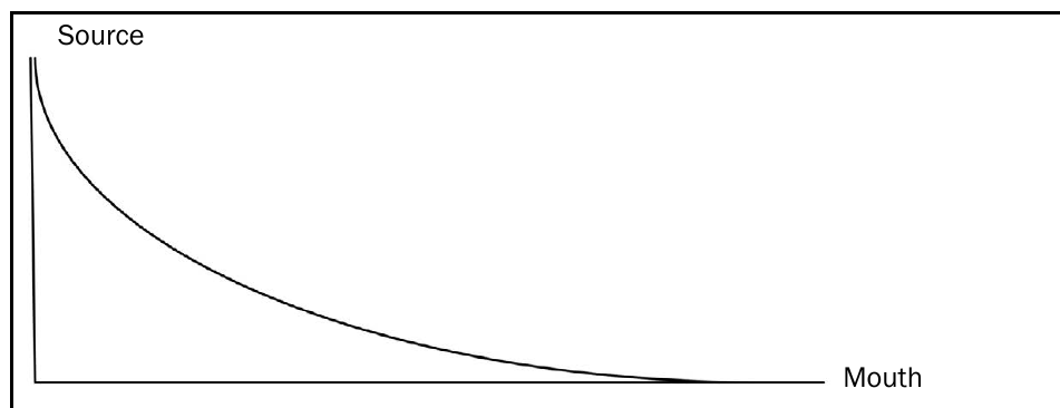
This curved profile develops because rivers expend most of their energy overcoming friction and cutting downwards in their upper reaches. As they flow downstream, they have less height to lose and more water volume, so they begin to meander and deposit sediments rather than cutting straight down.
The longitudinal profile demonstrates how a river's energy and behaviour change throughout its course, with steep, energetic upper sections giving way to gentler, wider lower sections.
Cross profiles through the river course
Cross profiles reveal how valley shapes transform dramatically as rivers develop. These profiles show us three distinct stages of river development, each with characteristic valley shapes.
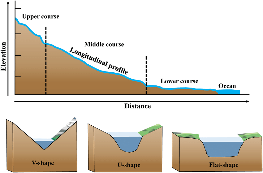
Cross Profile Development Through River Course
Upper Course: Narrow, steep-sided V-shaped valleys with small river channels
↓
Middle Course: Wider valleys with gentler slopes and developing floodplains
↓
Lower Course: Wide, flat-floored valleys with extensive floodplains
In the upper course, cross profiles show narrow, steep-sided V-shaped valleys. The river channel itself is narrow and shallow, occupying just a small portion of the valley floor. The valley sides are steep because the river's energy focuses on vertical erosion, cutting straight down through the landscape.
As we move to the middle course, cross profiles begin to show wider valleys with gentler slopes. The valley floor becomes broader, and the river channel starts to occupy more space as it begins to meander from side to side.
In the lower course, cross profiles reveal wide, flat-floored valleys with very gentle sides. The river channel becomes much wider, and extensive floodplains develop on either side of the river, creating the characteristic wide, flat profile of mature river systems.
River course characteristics and landforms
Understanding how rivers change from source to mouth helps us predict what landforms and features we'll find at different stages of river development.
Upper course characteristics
The upper course represents the river's youthful stage, where energy levels are high and vertical erosion dominates. Here, rivers create distinctive steep-sided V-shaped valleys through the process of downcutting. The narrow channels carve through resistant rock, often creating spectacular waterfalls where the river flows over bands of hard rock.
Gorges form in the upper course when rivers cut narrow, deep valleys through resistant rock layers. These dramatic landforms showcase the power of concentrated river energy in mountainous terrain.
Gorges form in the upper course when rivers cut narrow, deep valleys through resistant rock layers. The river follows a winding path around obstacles, creating interlocking spurs - projecting ridges that appear to interlock when viewed from downstream.
Middle course characteristics
In the middle course, rivers develop different characteristics as their energy balances between erosion and deposition. The valleys become more open with gentler slopes, and floodplains begin to develop as the river starts to deposit sediments during flood events.
Meanders become the dominant feature of the middle course, with rivers developing distinctive slip-off slopes on the inner bends where deposition occurs, and undercut slopes on the outer bends where erosion continues. The channel becomes wider as the river has more water volume from tributary inputs.
Lower course characteristics
The lower course represents the river's mature stage, where deposition becomes the dominant process. Wide, flat floodplains dominate the landscape, creating fertile agricultural land that has been built up by centuries of flood deposits.
Very wide channels characterise the lower course, as rivers need to accommodate large volumes of water from their entire drainage basin. Ox-bow lakes form when meandering rivers cut through narrow necks of land, leaving curved lakes as evidence of the river's former course.
The transition from erosion-dominated upper courses to deposition-dominated lower courses is fundamental to understanding river landform development. This change occurs because river energy decreases downstream while sediment load increases.
Visual development of river systems
Rivers demonstrate clear patterns of development that can be understood through both plan views (looking down from above) and oblique views (three-dimensional perspectives) that show the landscape's relief.
The plan view shows how rivers progress from simple, straight channels with few tributaries in the upper course, to complex meandering patterns with multiple channels and ox-bow lakes in the lower course. This progression reflects the changing balance between erosion and deposition as rivers mature.
The oblique views reveal how the three-dimensional landscape changes, from mountainous terrain with deep valleys in the upper course, to rolling hills in the middle course, to flat plains in the lower course.
Key Points to Remember:
-
River profiles help us understand how rivers change from source to mouth - longitudinal profiles show gradient changes while cross profiles reveal valley shape evolution
-
Upper course = steep and narrow - V-shaped valleys, waterfalls, gorges, and narrow channels characterise the energetic upper reaches where vertical erosion dominates
-
Middle course = wider and gentler - valleys open out, floodplains develop, and meandering becomes the dominant river pattern as erosion and deposition balance
-
Lower course = wide and flat - extensive floodplains, very wide channels, and ox-bow lakes develop as deposition becomes the primary process
-
Energy changes drive landform development - high energy in upper courses creates erosional features, while lower energy in lower courses creates depositional features