Latitude and Longitude (HSC SSCE Mathematics Standard): Revision Notes
Latitude and Longitude
Introduction to Earth's coordinate system
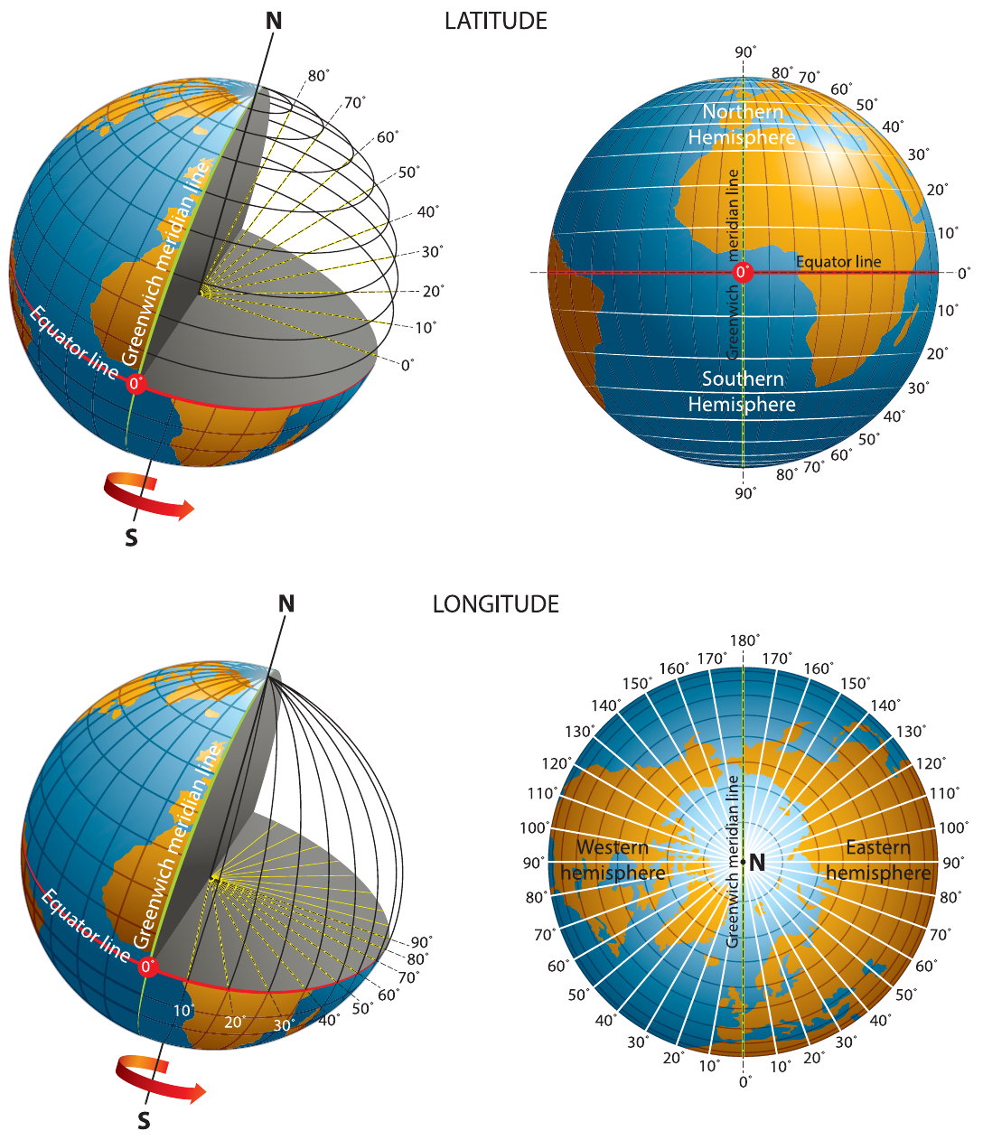
To pinpoint any location on Earth's surface, we use an imaginary grid system made up of lines called parallels of latitude and meridians of longitude. These imaginary lines form circles around the Earth and create a grid pattern that helps us specify exact positions on our planet's surface.
This coordinate system works similarly to how we use street addresses to find buildings, but instead of street names, we use angles measured in degrees.
Think of Earth's coordinate system like a giant game of battleship! The latitude and longitude lines create a grid that allows us to give every location on Earth a unique "address" using just two numbers.
What is latitude?
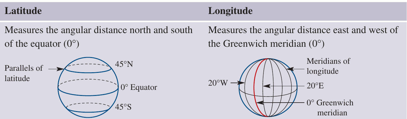
Latitude measures how far north or south a location is from the equator. Think of latitude lines as horizontal circles running parallel to the equator.
The equator itself is at latitude and divides Earth into two halves:
- The Northern Hemisphere (locations north of the equator)
- The Southern Hemisphere (locations south of the equator)
Latitude is measured as an angular distance from the equator, ranging from at the equator to at the North and South Poles. The angle is formed at Earth's centre between the equator and a line drawn to the specific parallel of latitude.
Understanding the angle: Imagine drawing a line from Earth's center to the equator, then another line from Earth's center to your location. The angle between these two lines is your latitude!
Key points about latitude:
- Measured in degrees north (N) or south (S) of the equator
- The equator is at latitude
- Maximum latitude is (at the poles)
- All latitude lines run parallel to each other
- Also called "parallels of latitude"
What is longitude?
Longitude measures how far east or west a location is from the Greenwich meridian. Longitude lines run vertically from the North Pole to the South Pole.
The Greenwich meridian (also called the Prime Meridian) is at longitude and divides Earth into:
- The Eastern Hemisphere (locations east of Greenwich)
- The Western Hemisphere (locations west of Greenwich)
Longitude is measured as an angular distance from the Greenwich meridian, ranging from to in either direction (east or west). The angle is formed at Earth's centre between the Greenwich meridian and a line drawn to the specific meridian of longitude.
Key points about longitude:
- Measured in degrees east (E) or west (W) of the Greenwich meridian
- The Greenwich meridian is at longitude
- Maximum longitude is (the International Date Line)
- All longitude lines meet at the North and South Poles
- Also called "meridians of longitude"
The Greenwich meridian
The Greenwich meridian (or Prime Meridian) is a special reference line for measuring longitude. It's an imaginary north-south line that passes through the town of Greenwich in London, England. This location was chosen as the international standard for longitude in 1884.
Just as the equator serves as the reference point for measuring latitude, the Greenwich meridian serves as the reference point for measuring longitude.
Why Greenwich? The location was chosen at an international conference because the Royal Observatory in Greenwich was already a major center for navigation and astronomy. This standardization made global navigation and timekeeping much easier!
How to read and write coordinates
When we write the coordinates of a location on Earth, we always follow this order:
Critical Rule: Latitude first (N or S), then longitude (E or W)
Remember this alphabetically: Latitude comes before Longitude!
For example, Sydney, Australia is located at . This tells us that Sydney is:
- south of the equator
- east of the Greenwich meridian
Finding positions on Earth's surface
Let's work through an example to understand how to identify locations using latitude and longitude.
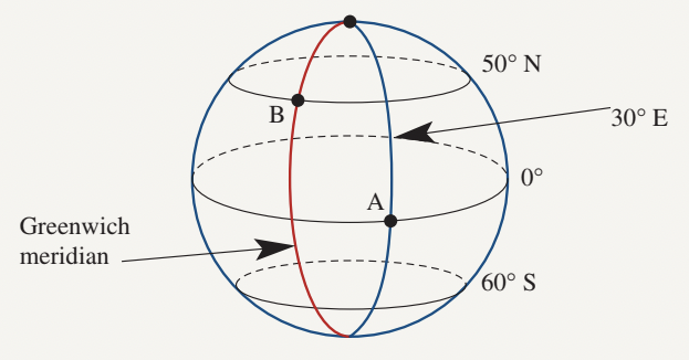
Worked Example: Finding coordinates from a diagram
The diagram shows Earth's surface with points A and B marked. Let's find their coordinates.
a) What is the latitude and longitude of point A?
Step 1: Find the latitude (angle north or south of the equator)
- Point A is on the equator
- Latitude =
Step 2: Find the longitude (angle east or west of Greenwich meridian)
- Point A is at
Answer: Point A is at
b) What is the latitude and longitude of point B?
Step 1: Find the latitude
- Point B is at (north of the equator)
Step 2: Find the longitude
- Point B is on the Greenwich meridian
- Longitude =
Answer: Point B is at
c) What are the coordinates of a point due south of point A?
Step 1: Point A is on the equator
- Moving south means the latitude becomes
Step 2: The longitude stays the same as point A
- Longitude =
Answer:
d) What are the coordinates of a point due east of point B?
Step 1: The latitude stays the same as point B
- Latitude =
Step 2: Point B is on the Greenwich meridian
- Moving east means the longitude becomes
Answer:
Calculating differences between locations
We can use latitude and longitude to compare the positions of different cities and calculate the angular distance between them.
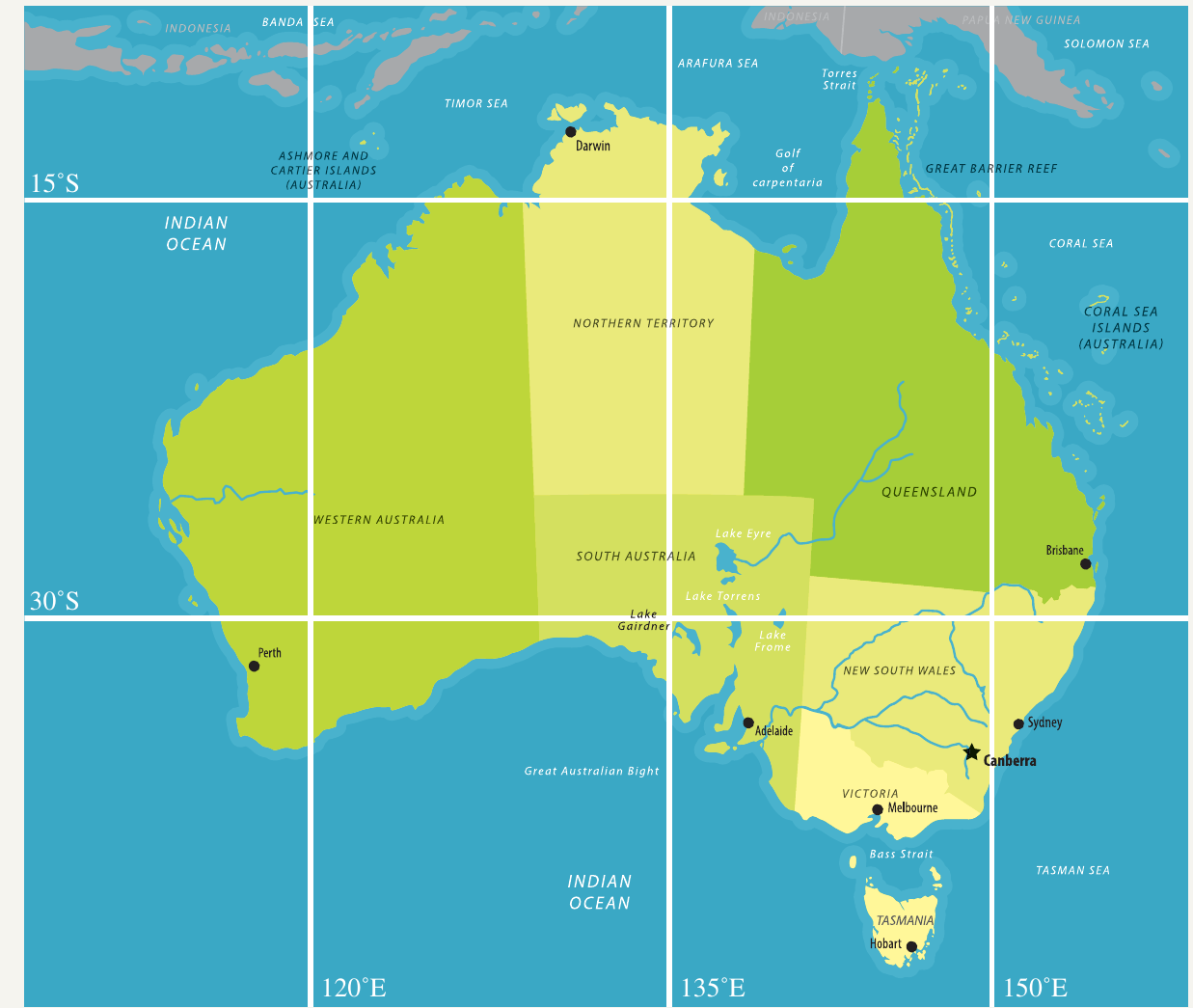
Worked Example: Comparing Australian cities
Brisbane is located at
Perth is located at
a) What is the difference in longitude between Brisbane and Perth?
Step 1: Identify the longitude of each city
- Brisbane:
- Perth:
- Both cities are east of the Greenwich meridian
Step 2: Subtract the angles to find the difference
Answer: The difference in longitude is
b) Which city is closer to the equator?
Step 1: Compare the latitudes
- Brisbane:
- Perth:
- Both cities are south of the equator
Step 2: The city with the smaller angle is closer to the equator
Answer: Brisbane is closer to the equator (because it has a smaller angle of latitude)
Exam tip: When calculating differences in longitude or latitude, make sure both locations are on the same side of the reference line (both east or both west for longitude; both north or both south for latitude). If they're on opposite sides, you need to add the angles instead of subtracting them.
Remember!
Key Points to Remember:
- Latitude measures angular distance north or south of the equator (), ranging from to
- Longitude measures angular distance east or west of the Greenwich meridian (), ranging from to
- Coordinates are always written as latitude first, then longitude, for example
- The equator divides Earth into Northern and Southern Hemispheres
- The Greenwich meridian divides Earth into Eastern and Western Hemispheres
- A smaller angle of latitude means the location is closer to the equator