Fieldwork (AQA A-Level Geography): Revision Notes
Fieldwork
Introduction to fieldwork investigation
During your A-Level Geography course, you are required to complete four days of fieldwork. This fieldwork must cover topics in both human and physical geography. The purpose is to assess your ability to apply geographical knowledge and skills to real-world situations and unseen contexts. The fieldwork will help you understand how geographical theory works in practice and develop important research and analytical skills.
Your fieldwork experience will involve working with actual data and real environments, giving you hands-on experience with the geographical concepts you learn in the classroom. This practical component is essential for developing a deeper understanding of geographical processes and patterns.
The independent investigation
A key requirement of your course is completing an independent investigation. This demonstrates your fieldwork knowledge, skills and understanding. You may work individually or as part of a group to collect field data and evidence, but your final investigation must be your own work.
Independent investigation requirements
Your independent investigation is a substantial piece of work that brings together all aspects of geographical enquiry. It must include several essential components to meet the assessment requirements.
Your investigation must:
- Be based on a research question or issue that you have developed yourself, relating to any aspect of the course content
- Include data and evidence collected from your own field investigations
- Incorporate results from your research along with relevant secondary data sources
- Include clear presentation and analysis of the data you have collected
- Draw meaningful conclusions from your analysis
The investigation allows you to pursue a geographical question that genuinely interests you, whilst demonstrating your ability to conduct rigorous geographical research.
Key skills for fieldwork
To successfully complete your fieldwork investigation, you need to develop a range of important geographical skills. These skills form the foundation of effective fieldwork and will be assessed throughout your investigation.
You need to be able to:
- Prepare thoroughly for fieldwork by conducting background reading, drawing up clear aims and objectives for your enquiry, and planning both field and secondary research
- Collect primary data in the field using appropriate sampling techniques whilst following health and safety procedures
- Use secondary data sources effectively alongside your field data
- Process and present data using relevant graphical and cartographical techniques to display your findings clearly
- Analyse data by applying appropriate statistical techniques where relevant
- Draw conclusions that relate directly back to your original aims and objectives, linking these to both the specific place you studied and the broader geographical concepts underpinning your enquiry
- Review the enquiry by evaluating its success and considering how it could be developed further
These skills build progressively throughout the fieldwork process, with each stage developing your capabilities as a geographical researcher.
The fieldwork pathway
The fieldwork investigation follows a clear sequential pathway with six key stages. Each stage is important and builds upon the previous one to create a comprehensive piece of geographical research. Understanding this pathway helps you structure your investigation effectively.
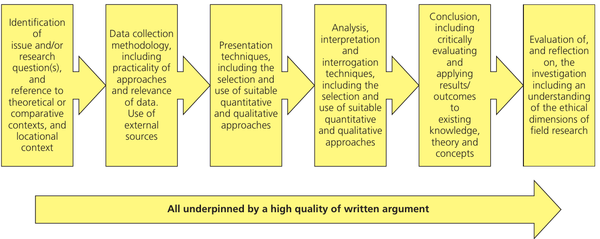
The pathway consists of:
Stage 1: Identification
This initial stage involves identifying your research question or issue and developing clear aims. You need to establish the theoretical or comparative context for your investigation and understand the locational context where you will conduct your fieldwork.
Stage 2: Data collection methodology
Here you plan your approach to gathering information. This includes deciding on your data collection methods, considering the practicality of different approaches, planning how you will use external sources, and ensuring your data collection is both quantitative and qualitative where appropriate.
Stage 3: Presentation
This stage focuses on how you will display your findings. You need to select appropriate presentation techniques, including both suitable quantitative and qualitative approaches to effectively communicate your data.
Stage 4: Analysis and interrogation
At this stage you examine your data in depth. You use suitable quantitative and qualitative techniques to interrogate what your data shows and what patterns or relationships emerge.
Stage 5: Conclusion
This involves drawing together your findings and critically evaluating them. You need to apply your results and outcomes to existing geographical knowledge, theory and concepts, showing how your investigation contributes to broader geographical understanding.
Stage 6: Evaluation and reflection
The final stage requires you to evaluate and reflect on your investigation. This includes considering the ethical dimensions of field research and thinking critically about the strengths and limitations of your approach.
Throughout all these stages, your work must be underpinned by a high quality of written argument. Clear, logical and well-structured writing is essential for communicating your geographical understanding effectively.
Choosing your fieldwork topic
Selecting an appropriate topic for your fieldwork investigation requires careful consideration. Your topic must be linked to an area of the AQA A-Level specification, and the aims of your investigation must be achievable within the constraints of the fieldwork you can conduct.
The main consideration is that your investigation must involve enquiry work outside the classroom that includes actual data collection in the field. This might include:
- Data collected at specialist field study centres
- Information gathered during work experience placements
- Research conducted using the internet
- Evidence from libraries or archives
Teacher guidance is invaluable when choosing your topic. Every student's situation is unique, so you need to select a topic where you can realistically meet the aims you set. Consider practical factors such as accessibility of field sites, safety considerations, and the time available for data collection.
Writing and submitting your report
After completing your fieldwork, you must write and submit a formal report. This report should be between 3,000 and 4,000 words in length and must be based on one or more aspects of your investigations. The report is marked by your teachers and then moderated by AQA to ensure consistent standards.
The topic you choose must be clearly linked to an area of the AQA A-Level specification. Your report should demonstrate your ability to conduct independent geographical research and analysis at an advanced level.
Geographical information systems and fieldwork
Geographical information systems (GIS) are highly effective mapping tools that can greatly enhance your fieldwork investigation. These digital tools allow you to record, visualise and analyse geographical data in sophisticated ways.
A number of websites and programs have great potential for fieldwork applications. Software such as Multimap, Aegis, Digital Worlds, Quikmaps and Google Earth offer different capabilities. Many programs allow you to combine maps and photographs in a single interface. Some software enables you to add annotations to maps, whilst others allow recorded data to be added. The complexity varies - some require training to use effectively, whilst others are more straightforward. The choice depends on your own ICT skill level and the requirements of your investigation.
GPS Technology in Fieldwork
Global positioning systems (GPS) technology is particularly useful in fieldwork. Data can be recorded at points along a transect or using other sampling systems, with the position of each point recorded simultaneously. This GPS-located data can then be fed into a GIS program, bringing your data recording and mapping together in one integrated system.
Big data and ICT skills in geography
Understanding big data and developing ICT skills are increasingly important aspects of geographical fieldwork. Traditional ICT tools such as Excel spreadsheets enable you to analyse data effectively, whilst modern technology like digital maps and remote sensing allows you to present geographical information in engaging and meaningful ways.
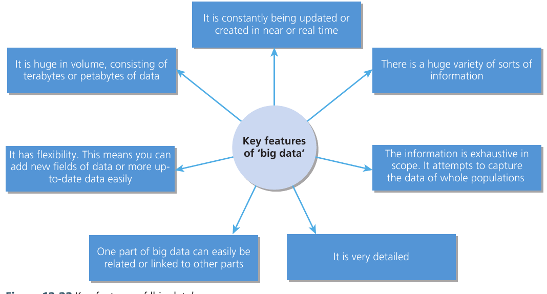
Big data has several key characteristics that make it valuable for geographical research:
- Huge volume - consisting of terabytes or even petabytes of data
- Real-time updates - constantly being updated or created in near real-time
- Variety - encompassing a huge range of different types of information
- Exhaustive scope - attempting to capture data for whole populations rather than samples
- Detailed - containing very high levels of detail
- Relational - one part can easily be related or linked to other parts
- Flexible - new fields of data can be added more easily to update the dataset
Software such as digital mapping tools and remote sensing technology (including programs like Multimap, Memory-map, Google maps, and Google Earth) enables you to present geographical data in interesting and accessible ways. These tools help you visualise spatial patterns and relationships that might not be apparent from raw data alone.

Key Points to Remember:
- You must complete four days of fieldwork covering both human and physical geography topics during your A-Level course
- Your independent investigation must be based on a research question you develop yourself and include both field data and secondary sources
- The fieldwork pathway has six sequential stages: identification, data collection, presentation, analysis, conclusion, and evaluation - all underpinned by high-quality written argument
- Your final report should be 3,000-4,000 words and must link clearly to the AQA A-Level specification
- GIS and GPS technology are valuable tools for recording, mapping and analysing geographical data during fieldwork