Case Study: The Sundarbans, Bangladesh (AQA A-Level Geography): Revision Notes
Case Study: The Sundarbans, Bangladesh
Introduction and location
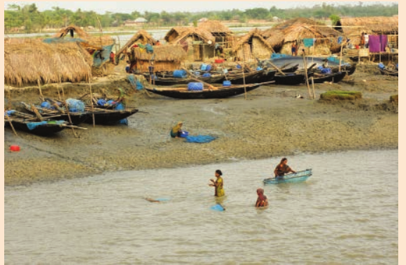
The Sundarbans is a coastal zone located at the world's largest delta, extending over 10,000 km² across southern Bangladesh and India on the Bay of Bengal. This delta has been formed from sediment deposited by three of the world's great rivers: the Ganges, Brahmaputra and Meghna. The natural climax ecosystems of the Sundarbans are mangrove forests and swamps.
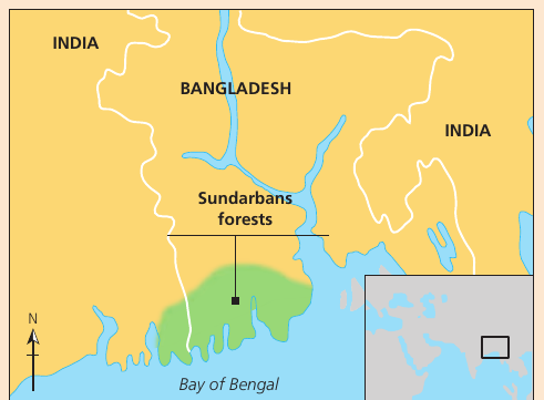
This unique coastal landscape represents millennia of river sediment deposition that has been shaped and maintained by tidal and wave action, creating diverse mangrove forests that have sustained local populations for generations. However, the equilibrium of the natural processes existing here is very delicate, and increasing pressures may be jeopardising its very existence.
The Sundarbans represents one of the world's most significant coastal ecosystems, where the interplay between three major river systems has created a unique and dynamic landscape. This delicate balance between natural processes and human activities makes it a critical area for studying coastal management and sustainability.
Physical characteristics and coastal processes
Tidal action and channel networks
Tidal action is the primary natural process that shapes this distinctive coastal landscape. A dense, well-developed network of interconnecting river channels flows across the clay and silt deposits. The location of the network of main channels remains relatively static because the silts and clays are quite resistant to erosion.
The larger channels are generally straight and up to two or more kilometres wide, flowing generally north to south due to the strong tidal currents. The extensive network of interconnecting smaller channels (called khals) drains the land with each powerful ebb tide.
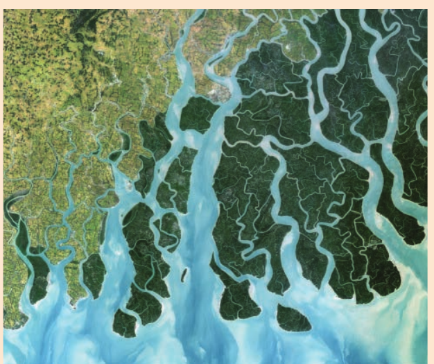
Khals are smaller interconnecting channels that drain land during ebb tide in the Sundarbans delta system. These channels are essential to the drainage system and play a crucial role in maintaining the health of the mangrove ecosystem by regulating water flow and salinity levels.
Sediment dynamics and island formation
Non-cohesive sediments like sand are washed out of the delta and deposited on banks, or chars at the river mouths, where the strong south-westerly monsoon winds then blow them into large ranges of sand dunes. With the protection of the dunes, finer silts washed into the bay are deposited, where wave action then adds and shapes further deposits of sand to form new islands.
Vegetation establishes itself and eventually, if the natural succession can proceed, the dense mangrove forests develop. These forests are home to the endangered Royal Bengal Tiger, for which the area is famous.
The process of island formation in the Sundarbans demonstrates the dynamic nature of deltaic environments. The sequence of sand deposition, dune formation, silt accumulation, and vegetation establishment creates a constantly evolving landscape that supports diverse ecosystems. Understanding these natural processes is essential for effective coastal management.
Ecosystem goods and services
The mangrove forests of the Sundarbans are an extremely important ecosystem for local populations, providing many economic and environmental opportunities. If managed sustainably, this coastal zone provides a wide range of goods and services.
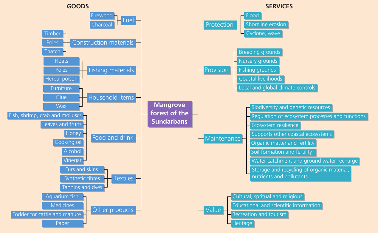
Goods provided
The mangrove ecosystem supplies numerous resources including:
- Construction materials: Timber, poles, thatch
- Fuel: Firewood and charcoal
- Fishing materials: Various equipment and supplies
- Household items: Furniture, glue, wax
- Food and drink: Fish, shrimp, crab, molluscs, honey, cooking oil, alcohol, vinegar, leaves and fruits
- Textiles: Furs, skins, synthetic fibres, tannins and dyes
- Other products: Aquarium fish, medicines, fodder for cattle and manure, paper
Services provided
The ecosystem delivers four main categories of services:
Protection services:
- Flood protection
- Shoreline erosion protection
- Cyclone and wave protection
Provision services:
- Breeding grounds for marine life
- Nursery grounds for fish species
- Fishing grounds
- Coastal livelihoods
- Local and global climate controls
Maintenance services:
- Biodiversity and genetic resources
- Regulation of ecosystem processes and functions
- Ecosystem resilience
- Support for other coastal ecosystems
- Organic matter and fertility
- Soil formation and fertility
- Water catchment and ground water recharge
- Storage and recycling of organic material, nutrients and pollutants
Value services:
- Cultural, spiritual and religious significance
- Educational and scientific information
- Recreation and tourism
- Heritage
Despite this wealth of goods and services, many from outside view this area of coastal Bangladesh as uninhabitable. However, traditionally (and perhaps surprisingly) coastal erosion has not been a problem; the main challenges facing local populations are outlined below.
Challenges facing the Sundarbans
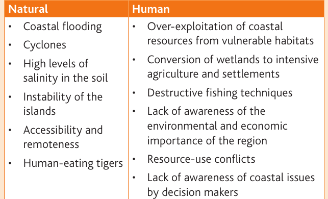
Natural challenges
The Sundarbans faces several natural threats:
- Coastal flooding: Regular inundation from high tides and storm surges
- Cyclones: Severe tropical storms bringing high winds and flooding
- High levels of salinity in the soil: Salt intrusion affects agriculture and freshwater supplies
- Instability of the islands: Dynamic coastal environment with shifting landforms
- Accessibility and remoteness: Difficult terrain and isolation from mainland services
- Human-eating tigers: Royal Bengal Tigers pose a risk to local communities
The natural challenges faced by the Sundarbans are inherent to its geographical location and coastal dynamics. While these threats are significant, local communities have traditionally developed adaptive strategies to live alongside these hazards. Understanding these natural challenges is essential for developing appropriate management and adaptation strategies.
Human-induced challenges
Human activities have created additional pressures:
- Over-exploitation of coastal resources from vulnerable habitats: Unsustainable harvesting of timber, fish and other resources
- Conversion of wetlands to intensive agriculture and settlements: Loss of natural habitat for farming
- Destructive fishing techniques: Methods that damage ecosystems
- Lack of awareness of environmental and economic importance of the region: Limited understanding of ecosystem value
- Resource-use conflicts: Competition between different user groups
- Lack of awareness of coastal issues by decision makers: Poor policy and management decisions
Human-induced challenges often compound natural threats, creating a multiplier effect that significantly reduces ecosystem resilience. Unlike natural challenges that communities have adapted to over generations, these anthropogenic pressures are often recent and escalating, making adaptation more difficult. Addressing these requires both community-level action and policy interventions.
Resilience of the Sundarbans
Natural resilience and protection
The wealth of goods and services has allowed local populations to remain resilient to the challenges of this low-lying coastal landscape. The mangrove forests provide a high level of resilience as they offer significant protection and shelter against:
- Storm winds
- Floods
- Tsunamis
- Coastal erosion
It is said that a density of 30 trees per 0.01 hectares can reduce the destructive force of a tsunami by up to 90 per cent. The coastal communities of the Sundarbans are said to be more resilient to natural disasters than other coastal communities elsewhere in Bangladesh.
Protection Demonstration: Mangrove Forest Impact
Research has shown that mangrove forests act as natural barriers:
- A properly maintained mangrove forest with 30 trees per 0.01 hectares can reduce tsunami force by up to 90%
- The dense root systems stabilize sediments and reduce wave energy
- Even degraded mangrove forests provide some level of protection, though at reduced effectiveness
- Communities behind healthy mangrove forests experience significantly less damage during cyclones compared to exposed coastal areas
Economic and ecological resilience
The fertility of the soil and ecological diversity provide a plentiful supply of a large range of nutritious foods. Despite the constant threats of flooding and storms, the forests have an economic value, even if used for traditional activities such as fishing, gathering crustaceans, or timber and tannin production.
Some estimate that just one hectare of mangrove forest has an annual economic value of over $12,000. This suggests that unlike many other local communities in other parts of Bangladesh, one of the poorest countries in the world, the mangroves could provide resilience against poverty, and opportunities for sustainable economic development for the people living there.
Human responses to challenges
Traditional resilience and adaptation
Traditionally many local populations have lived successful productive lives in the Sundarbans of Bangladesh. Life is not always easy, but by living with their environment rather than against it, they have coped with many of the natural challenges they face.
The traditional approach of working with natural processes rather than fighting against them demonstrates an important principle of sustainable coastal management. This philosophy has enabled communities to thrive in challenging environments for generations, offering valuable lessons for modern adaptation strategies.
Mitigation measures
Although vulnerable to many challenges in the coastal Sundarbans, its people moderate their risk in a number of ways. Some suggest that it is the strength of each community's resources that helps to mitigate the worst impacts of this challenging environment.
Primarily, prior to more recent human pressures like deforestation, overfishing, intensive agriculture and settlement growth, the communities of the Sundarbans could utilise a number of open access natural resources. These included:
Open access natural resources are resources available for use by local communities without individual ownership restrictions. These common resources have historically been crucial for community resilience, providing a safety net during difficult times. However, the shrinking availability of these resources due to privatization, degradation, and over-exploitation threatens traditional livelihoods.
- Khas land: Government-owned lands that are supposed to be protected for use by local populations
- Wetlands and fisheries
- Forests
Physical infrastructure
The ever-present threat of natural disasters has meant that in some areas of the Sundarbans there has been significant investment in the physical infrastructure, including:
- Roads
- Telecommunications
- Schools
- Hospitals
- Cyclone shelters (flood protection and tube wells)
These mitigate the risks communities face.
Social capital and community organisation
Many communities of the Sundarbans are said to have good levels of social capital from the legal frameworks and services provided by a number of formal government and NGO organisations. These work alongside the traditional laws, tenets and social sanctions that communities have used for generations to manage their use of the region.
There is some economic value to the resources of the area and together with financial resources like access to micro-credit, some Sundarbans communities have a greater economic safety net than other vulnerable groups in Bangladesh.
Livelihood assets
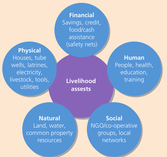
The diagram above summarises the livelihood assets that help mitigate the challenges of the Sundarbans. These five interconnected capital assets include:
Financial capital:
- Savings, credit
- Food/cash assistance
- Safety nets
Human capital:
- People, health
- Education
- Training
Social capital:
- NGO/cooperative groups
- Local networks
Natural capital:
- Land, water
- Common property resources
Physical capital:
- Houses, tube wells
- Latrines, electricity
- Livestock, tools
- Utilities
Declining resilience
In recent decades the level of resilience provided by these livelihood assets may be decreasing as poverty and marginalisation of some coastal communities increases due to:
- Shrinking of the open access resources
- Degradation of ecosystems
- Corruption of both local and national political institutions
- Conflicts over land ownership
- Increasing deaths of tigers (if wives are widowed they can often face very limited opportunities in this male-dominated society, especially as many marry very young before completing their formal education)
The decline in resilience represents a critical turning point for Sundarbans communities. The erosion of livelihood assets creates a vicious cycle where reduced access to resources leads to over-exploitation of remaining resources, further degrading the ecosystem. This trend must be reversed through coordinated action at local, national, and international levels.
Adapting to climate change
In the past it appears that people of the Sundarbans have adapted well to their coastal environment and in some places many have prospered on the natural bounty. However, it is almost inevitable that the impacts of climate change may pose the greatest risk to current and future generations in southern Bangladesh.
Generations of people have been sustained by the coastal mangrove forests of the Sundarbans. However, population pressure and the unpredictable impacts of future climate change may prove too hard to adapt to for many.
Climate change represents an unprecedented challenge for the Sundarbans. Unlike historical environmental changes that occurred gradually, allowing communities time to adapt, climate change is accelerating rapidly. The combination of sea-level rise, increased storm intensity, changing rainfall patterns, and rising temperatures threatens to overwhelm traditional coping mechanisms. Urgent action is needed to support adaptation efforts.
Future challenges and adaptations
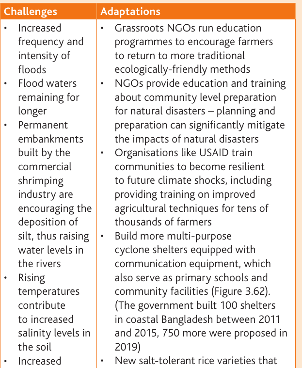
Key challenges:
- Increased frequency and intensity of floods
- Flood waters remaining for longer periods
- Permanent embankments built by the commercial shrimping industry encouraging the deposition of silt, causing water levels in the rivers to rise
- Rising temperatures contribute to increased salinity in the soil
- Increased pesticide and fertiliser use is affecting water quality
- Changes in seasonal patterns of rainfall
Key adaptations:
Education and training:
- Grassroots NGOs run education programmes to encourage farmers to return to more traditional ecologically-friendly methods
- NGOs provide education and training about community level preparation for natural disasters
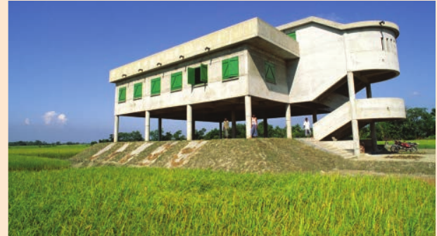
Infrastructure development:
- Building more multi-purpose cyclone shelters equipped with communication equipment, which also serve as primary schools and community facilities
- The government built 100 shelters in coastal Bangladesh between 2011 and 2015, with 750 more proposed by 2019
Agricultural innovation:
- Development of new salt-tolerant rice varieties that can survive being submerged in sea water for over two weeks
- NGOs build latrines on higher ground and educate communities about water and sanitation, and water-borne diseases
Climate resilience programmes:
- Organisations like USAID train communities to become resilient to future climate shocks, including providing training on improved agricultural techniques for tens of thousands of farmers
Water management:
- Installing storage tanks for rainwater in areas at most risk from inundation by salt water
- Distributing water-tight containers to store important belongings and papers during floods
Adaptation Success: Salt-Tolerant Rice
The development of salt-tolerant rice varieties demonstrates how innovation can help communities adapt to climate change:
Challenge: Traditional rice varieties die when submerged in salt water for more than a few days
Solution: Scientists developed new varieties that can survive submersion in sea water for over two weeks
Impact:
- Farmers can continue rice cultivation in areas affected by salt water intrusion
- Reduces food insecurity during flooding events
- Provides economic stability for farming communities
- Demonstrates the importance of agricultural research in climate adaptation
Opportunities for sustainable development
The threats to the mangrove forests and peoples of the Sundarbans may appear bleak, however with timely intervention and careful management there are opportunities for the sustainable development of this unique coastal zone in the future:
- The region has many international and national designations already in place
- There are opportunities for eco-tourism in the mangrove forest and wetland areas
- There has been recent investment to improve communications in the region
The Sundarbans represents both significant challenges and important opportunities for coastal communities in Bangladesh. With careful management and sustainable practices, this unique ecosystem can continue to provide for future generations whilst maintaining its ecological integrity.
Despite the significant challenges, there is reason for optimism. The Sundarbans has demonstrated remarkable resilience over centuries, and with modern scientific knowledge combined with traditional ecological wisdom, sustainable development is achievable. The key lies in balancing economic development with environmental conservation, ensuring that both people and nature can thrive together.
Remember!
Key Points to Remember:
-
The Sundarbans is the world's largest delta ecosystem (10,000 km²), formed by the Ganges, Brahmaputra and Meghna rivers, supporting extensive mangrove forests
-
Mangrove forests provide crucial ecosystem services including flood protection, cyclone defence, biodiversity support, and numerous economic goods (timber, fish, honey, medicines)
-
Communities face both natural challenges (cyclones, flooding, salinity, tigers) and human-induced pressures (over-exploitation, wetland conversion, destructive fishing practices)
-
Traditional resilience comes from five livelihood assets: financial, human, social, natural, and physical capital, though these are declining due to resource degradation
-
Climate change adaptation strategies include building multi-purpose cyclone shelters, developing salt-tolerant rice varieties, community education programmes, and improved water management systems
-
The annual economic value of mangrove forests ($12,000 per hectare) demonstrates their importance for poverty reduction and sustainable development
-
A density of 30 trees per 0.01 hectares can reduce tsunami force by up to 90%, highlighting the protective value of mangrove forests