Coastal Landscape Development - Erosion (AQA A-Level Geography): Revision Notes
Coastal Landscape Development - Erosion
Introduction to coastal landscapes
Coastal landscapes are dynamic zones where land meets the sea. These landscapes are constantly shaped by the interaction of several key factors:
- The geological characteristics and rock types present (lithology)
- Climate conditions affecting weathering and erosion rates
- The nature and power of tides and waves acting on the coastline
No two coastlines are identical. Each location develops unique features based on its particular combination of these factors. Coastal landscapes can be broadly classified in several ways:
- By alignment: Concordant (geology runs parallel to coast) or discordant (geology runs perpendicular to coast)
- By energy level: High energy coasts (exposed to powerful waves) or low energy coasts (sheltered locations)
- By dominant process: Erosion-dominated or deposition-dominated coastlines
Understanding coastal erosion is essential because it explains how many of our most dramatic coastal features form, from towering cliffs to isolated sea stacks standing proudly in the ocean. The processes operating at coastlines create some of Earth's most spectacular landscapes.
Headlands and bays
Formation process
Where a coastline consists of alternating bands of resistant and less resistant rock types running perpendicular to the shore (a discordant coastline), the differential rates of erosion create a distinctive landscape pattern of headlands and bays.
The process works as follows:
- Less resistant rocks (such as clay, sand, or weak sandstone) erode more rapidly under wave attack
- This creates sheltered indentations called bays
- More resistant rocks (such as chalk, limestone, or granite) erode much more slowly
- These harder rocks are left protruding into the sea as headlands
Once this pattern is established, wave refraction plays a crucial role. As waves approach the irregular coastline, they bend around the headlands. This concentrates wave energy on the headland sides, where the most powerful erosion occurs. Meanwhile, the bays receive lower energy waves, allowing sediment to accumulate and beaches to form, which further protects the bay from erosion.
Wave Refraction and Energy Distribution
Wave refraction is the key mechanism that maintains the headland and bay pattern once formed. By concentrating erosive energy on headlands while reducing it in bays, wave refraction creates a self-reinforcing cycle that perpetuates the distinctive coastal morphology.
Case study: Purbeck coast, Dorset
The Purbeck coast in Dorset provides an excellent example of headland and bay formation. Here, the geology consists of alternating bands of rock with varying resistance to erosion.
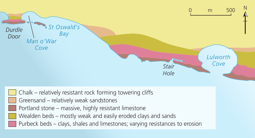
The geological structure includes:
- Chalk: Relatively resistant rock forming prominent cliffs
- Greensand: Relatively weak sandstone that erodes more easily
- Portland stone: Massive, highly resistant limestone
- Wealden beds: Mostly weak and easily eroded clays and sands
- Purbeck beds: Clays, shales and limestones with varying resistance
This alternating geology has created distinctive features including Lulworth Cove (a bay), Durdle Door (an arch in a headland), Man o'War Cove, St Oswald's Bay, and Stair Hole. The sea level rise over the last 10,000 years has slowly inundated valleys running parallel to the coastline, creating the intricate pattern visible today.
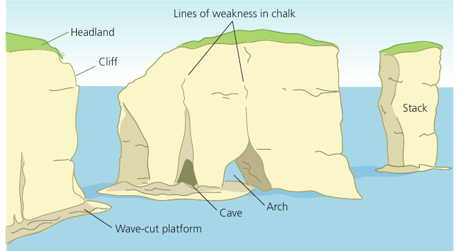
Cliffs and wave-cut platforms
How cliffs retreat
When powerful waves repeatedly break at the base of a coastal cliff, they concentrate enormous erosive energy in a small area. This creates a distinctive erosional feature and sets in motion a cycle of cliff retreat.
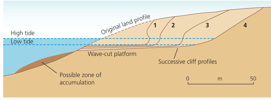
The process occurs in stages:
- Initial wave attack: High-energy waves break at the cliff base, focusing erosive power through hydraulic action and abrasion
- Notch formation: A wave-cut notch develops - an indentation carved into the cliff base
- Increasing stress: As the notch deepens, the cliff above becomes increasingly unsupported and unstable
- Collapse: Eventually the overhanging section collapses due to gravity, often aided by sub-aerial weathering processes weakening the rock
- Platform development: Continued erosion smooths the base, creating a gently sloping wave-cut platform
Wave-cut platform
A wave-cut platform is a gently sloping (less than 5°), relatively smooth marine platform formed by abrasion at the base of a cliff. It extends from the cliff base out to sea. This feature is diagnostic of marine erosion and provides clear evidence of cliff retreat over time.
Platform characteristics
Wave-cut platforms continue to grow wider as the cliff retreats. However, this growth is self-limiting. As waves must travel across increasing amounts of platform before reaching the cliff, they break further out and lose energy through friction. This dissipates wave power, reducing erosion rates on the cliff face and slowing platform growth. Most experts suggest platforms rarely exceed 0.5 km in width.
If the platform remains in the tidal zone, it is continuously exposed to erosion cycles and sub-aerial weathering. This creates a dynamic environment where both marine and terrestrial processes operate together to shape the platform surface.
The surface may develop interesting features:
- Rock pools in depressions
- Fissures and cracks
- Jagged, uneven surfaces
- Areas of smoother rock where erosion is more uniform
Geos, caves, blowholes, arches, stacks and stumps
These erosional features represent a sequence of landform development on cliffed coastlines. They are particularly well-developed on headlands, where wave energy is concentrated.
The erosional sequence
The formation follows a logical progression:
Stage 1: Geo formation
A geo is a narrow, steep-sided coastal inlet. It forms when the sea exploits lines of weakness in the rock - such as cracks, fissures, joints, or bedding planes. Wave action widens these weaknesses, cutting inland to create the characteristic narrow inlet shape.
Stage 2: Cave development
Where a cliff face has a zone of particularly weak rock or a major line of weakness, concentrated wave erosion can hollow out a cave at the cliff base. Caves typically have an opening on one side only (facing the sea).
Stage 3: Blowhole creation
In some circumstances, erosion works both horizontally (forming the cave) and vertically. If the cave is positioned on the side of a headland, erosion may cut vertically upward until it breaks through to the cliff top, creating a blowhole - a hole through which water can be forced upward during high tide or storm conditions.
Blowholes are dramatic features that demonstrate the power of marine erosion. During storms or high tides, water can be forced through the blowhole with considerable force, creating spectacular jets of spray that can reach several meters into the air.
Stage 4: Arch formation
When a cave forms on one side of a narrow headland, wave refraction means similar erosion occurs on the opposite side. If both caves eventually meet, or if one cave erodes completely through the headland, an arch is formed - a natural bridge of rock with the sea passing beneath it.
Stage 5: Stack isolation
Over time, continued marine erosion from below and sub-aerial weathering from above weaken the arch. The arch will eventually collapse due to gravity, leaving an isolated pillar of rock standing in the sea - a stack. The base of a stack often shows evidence of the former wave-cut notch.
Stage 6: Stump remains
Further erosion continues to attack the stack. Eventually, it too will be eroded down to a low stump, which may only be visible at low tide. A small portion of the original wave-cut platform may mark where the stack once stood.
Understanding the Sequence
The progression from geo through to stump represents a continuum of erosion. Each stage naturally leads to the next as marine and sub-aerial processes continue to attack the coastline. This sequence can take thousands of years to complete and demonstrates the relentless power of coastal erosion.
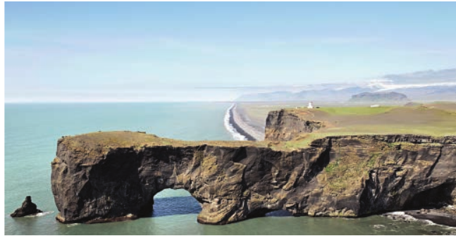
Notable examples worldwide
Spectacular examples of these features can be found globally:
- Cape Dyrhólaey, Iceland: The southern headland features impressive caves, arches and coastal stacks carved from volcanic rock
- Twelve Apostles, Australia: Famous limestone stacks off the Victoria coast
- Old Harry Rocks, Dorset: Chalk stacks on the Purbeck coast, with Durdle Door nearby providing an excellent arch example
- Parus Rock (Sail Rock), Black Sea: A well-known isolated stack
On the Purbeck coast, the sequence from headland through to stacks can be clearly traced. The Portland stone limestone has formed the famous Durdle Door arch, while chalk escarpments in The Foreland contain Old Harry Rocks - detached chalk stacks that demonstrate the final stages of this erosional sequence.
Key Points to Remember:
-
Headlands and bays form on discordant coastlines where alternating resistant and weak rocks erode at different rates, creating a distinctive indented coastline pattern.
-
Wave-cut platforms develop through a cycle of erosion: waves cut a notch at the cliff base, the cliff collapses, and repeated cycles create a gently sloping platform extending seaward.
-
Erosional features follow a predictable sequence: geo → cave → blowhole/arch → stack → stump, representing progressive stages as erosion continues.
-
Wave refraction concentrates energy on headlands, making them particularly vulnerable to erosion and explaining why caves, arches and stacks typically develop on headland sides.
-
Real-world examples are essential for understanding - locations like Purbeck (Dorset), Cape Dyrhólaey (Iceland), and the Twelve Apostles (Australia) demonstrate these processes clearly.