Submergent Coastlines (AQA A-Level Geography): Revision Notes
Submergent Coastlines
What are submergent coastlines?
Submergent coastlines develop when sea levels rise relative to the land, causing coastal areas and valleys to become flooded. This process creates distinctive coastal landforms where the sea has drowned pre-existing landscapes. The main types of submergent features include rias, fjords and Dalmatian coasts.
Rias
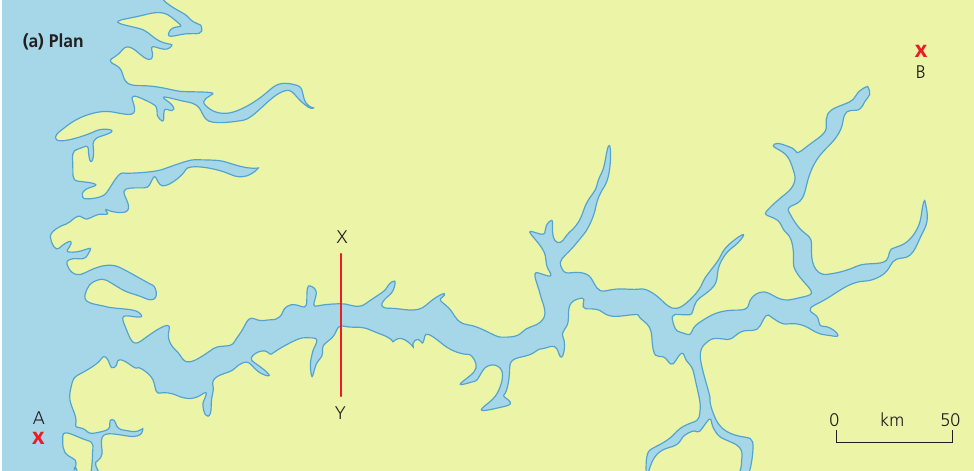
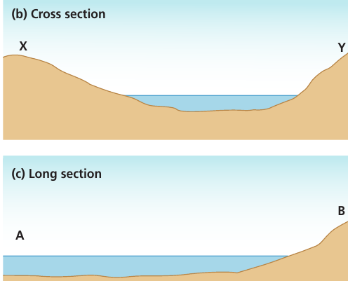
A ria is a flooded river valley created when rising sea levels drown the lower course of a river system.
How rias form
When sea levels rise, they flood river valleys from the mouth upstream. The river's floodplain becomes submerged beneath the advancing waters. However, only the middle and upper course valleys fill with seawater - the higher land surrounding these valleys remains dry, creating the characteristic ria landscape.
The selective flooding of rias is key to understanding their formation. While lower valleys fill with water, the surrounding uplands remain exposed, creating the distinctive branching pattern we associate with these features.
Key characteristics of rias
- Display a dendritic drainage system - a tree-like branching pattern inherited from the original river network
- Have a long section and cross profile that mirrors the original river valley shape
- Show a gradual transition from shallow water near the mouth to deeper water upstream
- Feature irregular, winding coastlines with multiple inlets
Examples of rias
Southwest England provides excellent examples of rias:
Real-World Examples: UK Rias
Fowey estuary, Cornwall - formed when rising seas flooded the River Fowey valley and the uplands of Cornwall
Kingsbridge estuary, South Devon - created when the sea level rose and drowned valleys of rivers flowing off Dartmoor
In both cases, the higher land of Dartmoor and the Cornish uplands remained above sea level, while the lower valley sections became submerged.
Fjords
A fjord is a drowned glacial valley with characteristically steep sides and great depth, formed when rising sea levels flood valleys previously carved by glaciers.
How fjords form
Fjords develop when glacial valleys become flooded by rising seas. These valleys were originally carved by thick ice during glacial periods. When the ice melted and sea levels rose, seawater invaded these deep, U-shaped valleys, creating fjords.
Key characteristics of fjords
Fjords possess several distinctive features that set them apart from other submergent landforms:
- Steep, cliff-like valley sides that plunge almost vertically into deep water
- U-shaped cross section - a characteristic profile inherited from glacial erosion
- Remarkably straight and narrow compared to the winding nature of river valleys
- Extreme depths - often exceeding 1,000 metres
- Hanging valleys on either side - smaller glacial valleys that enter the main fjord high up on the valley sides
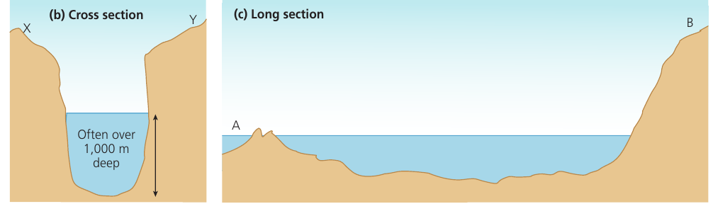
The fjord threshold
An important feature of fjords is the threshold - a shallower section found at the seaward end (mouth) of the fjord. This occurs because:
Understanding the Threshold
The fjord is not deepest at its mouth, but inland where a glacial rock basin was carved. The threshold represents an area where glacial erosion was reduced. This happened as the glacier made contact with the sea and the ice became thinner, reducing its erosive power.
- The fjord is not deepest at its mouth, but inland where a glacial rock basin was carved
- The threshold represents an area where glacial erosion was reduced
- This happened as the glacier made contact with the sea and the ice became thinner, reducing its erosive power
Global distribution of fjords
Fjords are typically found along coastlines in high-latitude regions that experienced significant glaciation:
- Norway - the classic location for well-developed fjords
- Southwestern New Zealand
- British Columbia, Canada
- Southern Chile
- Greenland
- Western Scotland - contains fjords that are less developed than those in Norway because the ice was not as thick and did not last for the same length of time
Scottish fjords are less spectacular than their Norwegian counterparts because the ice sheets covering Scotland were not as thick and did not persist for as long, resulting in less dramatic glacial erosion.
Examples of fjords
Famous Fjord Examples
Sogne Fjord, Norway:
- Nearly 200 kilometres in length
- One of the world's longest and most spectacular fjords
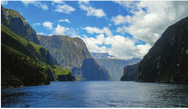
Milford Sound, New Zealand:
- A dramatic fjord featuring towering cliffs and deep blue waters
- Popular tourist destination showcasing classic fjord characteristics
Dalmatian coasts
A Dalmatian coast forms where the topography runs parallel to the coastline. When sea levels rise, valleys that are aligned parallel to the coast (rather than at right angles) become flooded.
How Dalmatian coasts form
Unlike rias and fjords where valleys run perpendicular to the coast, Dalmatian coasts develop where valleys run parallel to the shoreline. When sea level rises, these parallel valleys become flooded, creating a distinctive pattern where islands and peninsulas are aligned parallel to, but just offshore from, the mainland.
Key characteristics
The defining features of Dalmatian coasts include:
- Flooded valleys oriented parallel to the main coastline
- Islands and peninsulas running in elongated strips parallel to the coast
- Valleys run alongside the coast rather than at right angles to it
Example location
The name derives from the Croatian coast along the Adriatic Sea, where this distinctive parallel pattern of islands and coastline is particularly well developed.
Key Points to Remember:
-
Submergent coastlines form when rising sea levels flood existing landscapes, creating distinctive drowned features
-
Rias are drowned river valleys with dendritic drainage patterns - look for examples in southwest England (Fowey and Kingsbridge estuaries)
-
Fjords are drowned glacial valleys with U-shaped cross sections, steep cliff-like sides, and extreme depths (often over 1,000m) - best developed in Norway and New Zealand
-
Fjords have a threshold (shallow section) at their mouth because glacial erosion decreased as the ice thinned near the sea
-
Dalmatian coasts feature parallel patterns where flooded valleys, islands and peninsulas run alongside the main coast rather than perpendicular to it