Biomes (AQA A-Level Geography): Revision Notes
Biomes
What is a biome?
The Earth's surface shows remarkable variation in the types of plants and animals found in different regions. This variation is not random but follows clear patterns linked to environmental conditions. Three main factors shape these patterns: climate conditions, landscape features (topography), and soil characteristics. Together, these factors determine which species can survive in a location and how ecosystems function.
When we group biological communities that share similar climate conditions and characteristic vegetation, we create categories called biomes. These categories help us understand and organise the diversity of life on Earth.
Definition of a Biome
A biome is a large geographical area containing distinctive plant and animal communities that have reached the climatic climax stage of succession. It represents a global-scale ecosystem named after its dominant vegetation type.
Each biome consists of numerous smaller ecosystems. Whilst no two locations have exactly identical species, ecosystems within the same biome share similar characteristics.
Similar Ecosystems Across Continents
Mediterranean scrubland ecosystems in southern California, southern France, Chile, South Africa and Australia all function in comparable ways despite being on different continents. This is because they experience similar climate patterns: cool, wet winters and hot, dry summers.
Factors controlling biome distribution
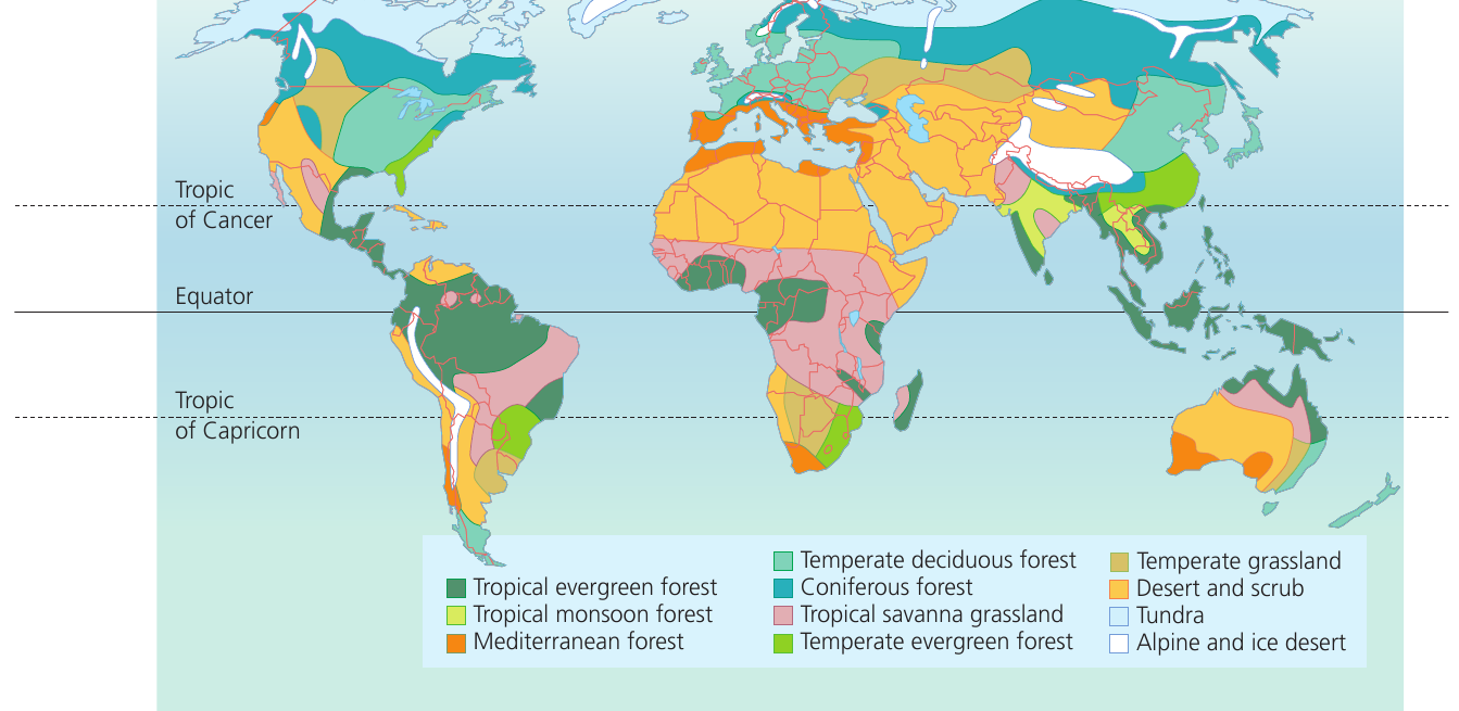
The global distribution of biomes follows predictable patterns because they are fundamentally controlled by climate. Temperature and soil moisture levels, which are largely determined by latitude, create the conditions that favour particular vegetation types. Plants adapted to local conditions become the dominant vegetation, giving each biome its distinctive character.
When examining global maps of vegetation and climate side by side, the relationship becomes clear. Areas with similar climate conditions support similar biome types, even when separated by thousands of kilometres. A third map showing soil distribution at the same scale would reveal further connections between these environmental factors.
The Diversity of Biomes
There are 11 major terrestrial (land-based) biomes recognised globally, along with several marine and aquatic biomes. Each terrestrial biome contains many individual ecosystems whose plant and animal communities have adapted to local environmental conditions over time.
Climate zones and biome patterns
The strong relationship between climate and biome distribution reflects how temperature and precipitation patterns vary across the planet. Different climate zones create the conditions necessary for specific vegetation types to thrive.
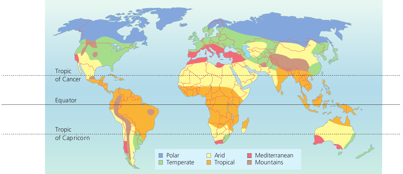
The Climate-Biome Connection
Comparing climate zone maps with vegetation distribution maps reveals striking similarities:
- Tropical climates support tropical forests
- Temperate climates enable deciduous and evergreen forests
- Arid climates result in desert vegetation
This demonstrates how climate acts as the primary control on biome distribution.
Classifying biomes: the Whittaker approach
An American ecologist named Robert Whittaker developed an elegant way to classify biomes based on climate data. He collected temperature and rainfall measurements from locations worldwide and plotted them on a single graph. By examining which biomes occurred at different temperature and precipitation combinations, he created a classification system.
The Whittaker diagram shows how biomes relate to two key climate variables: mean annual temperature (measured along the horizontal axis) and annual precipitation (measured along the vertical axis). This visual representation helps us understand why particular biomes occur where they do.
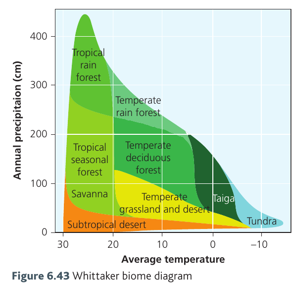
Patterns in the Whittaker Diagram
The diagram reveals several important patterns:
- Biomes requiring high precipitation (such as tropical rainforests) appear at the top
- Biomes adapted to dry conditions (such as deserts) appear at the bottom
- Temperature variations separate tropical biomes on the right from cold-climate biomes like tundra on the left
This classification system demonstrates that biome distribution ultimately depends on the interaction between temperature and moisture availability.
Tropical evergreen forest
Location and distribution
Tropical evergreen forests represent one of Earth's most productive and biodiverse biomes. These forests occur in a belt extending roughly 10° north and 10° south of the Equator. The major areas include:
-
The Amazon river basin in South America, with over half located in Brazil. This region contains approximately one-third of the world's remaining equatorial forests.
-
Equatorial Africa, including extensive areas in the Republic of Congo, the Central African Republic, and Gabon.
-
The Guinea coast of West Africa, with isolated forest pockets stretching from Liberia to Cameroon.
-
Southeast Asia and Oceania, particularly Malaysia, Indonesia and Papua New Guinea.
Climate characteristics
The tropical evergreen forest biome experiences a distinctive equatorial climate that remains remarkably stable throughout the year. Understanding these climate conditions helps explain why such lush vegetation can thrive in these regions.
Temperature patterns
The climate is characterised by consistently high temperatures with minimal seasonal variation. Average temperatures rarely fall below 24°C or rise above 28°C, creating a narrow range that remains stable year-round. The phrase "hot all year round" accurately describes conditions in this biome.
Daily Temperature Variation
During daytime, temperatures may climb above 30°C as the Sun reaches high angles in the sky. However, nights remain very warm, creating a low diurnal (daily) range of temperature. This means the difference between day and night temperatures is small.
The consistently high Sun angle throughout the year, combined with year-round cloud cover that moderates temperature extremes, explains these stable conditions.
Precipitation patterns
Rainfall is abundant and occurs throughout the year, with the statement "wet all year round" capturing the essence of precipitation in this biome. There are no distinct dry seasons, ensuring plants have continuous access to moisture.
Why So Much Rain?
The high temperatures drive strong convection, lifting warm, moist air that produces regular rainfall. Cloud cover is common, contributing to both rainfall and temperature moderation. This creates the perfect conditions for the lush vegetation characteristic of tropical evergreen forests.
Key Points to Remember
-
A biome is a large-scale ecosystem characterised by distinctive vegetation types adapted to specific climate conditions.
-
Three key factors determine biome distribution: climate (especially temperature and precipitation), topography, and soil characteristics.
-
The Whittaker diagram provides a useful classification system showing how biomes relate to mean annual temperature and precipitation levels.
-
Tropical evergreen forests occur within 10° of the Equator and experience consistently hot (24-28°C) and wet conditions year-round.
-
Global patterns show clear correlations between climate zones and biome distribution, demonstrating climate's fundamental role in controlling vegetation types.