Case Study: Ecological Change in the Sundarbans (AQA A-Level Geography): Revision Notes
Case Study: Ecological Change in the Sundarbans
Introduction
The Sundarbans mangrove delta is one of the world's most ecologically important yet vulnerable regions. This vast area faces significant pressures from both human activities and environmental changes, making it a critical case study for understanding ecosystems under stress.
Location and geographical setting
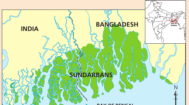
The Sundarbans is located at the mouth of the Ganges River system in the Bay of Bengal. The region spans the border between India and Bangladesh, covering approximately 10,000 km², with 60% of the area lying within Bangladesh.
Key geographical features include:
- Low-lying vegetated islands with elevations between 0.9 and 2.1 metres above mean sea level
- An intricate network of waterways and channels forming a complex delta system
- Spread across West Bengal (India) and southern Bangladesh
- Formed by the confluence of three major rivers: Ganges, Padma-Brahmaputra and Meghna
Climate characteristics:
The region experiences a monsoon climate with distinct seasonal patterns. Between June and September, the monsoon brings heavy rainfall and frequent devastating cyclones. Annual rainfall can exceed 3,500 mm, whilst daytime temperatures during monsoon months can reach 48°C.
Population:
The Sundarbans delta is home to over 4.5 million people, making it both an ecologically fragile and densely populated region. This combination of environmental sensitivity and high human pressure creates significant management challenges.
Biodiversity and ecological significance
The Sundarbans is renowned for having the most extensive mangrove forests in the world, covering over 10,000 km². These forests provide critical ecosystem services and support exceptional biodiversity.
Species diversity includes:
- 334 plant species
- 693 fauna species
- 210 species of fish
- 38 species of crustaceans
Important wildlife:
The region is home to many rare and globally threatened species, including:
- Estuarine crocodile
- Royal Bengal tiger
- Water monitor lizard
- Gangetic dolphin
- Olive ridley turtle
What is an Ecoregion?
An ecoregion is a contiguous area characterised by well-defined similarity in flora and fauna as well as geomorphology, climate and soils. Ecoregions do not follow political boundaries or landscape alterations by humans.
Conservation designations:
The Sundarbans has received international recognition for its ecological importance. The Worldwide Fund for Nature (WWF) has designated it as one of 867 ecoregions globally. Additionally, UNESCO has recognised the area as a World Heritage Site due to:
- Its wide variety of species
- Its role as an example of delta formation
- The subsequent colonisation of newly-formed deltaic islands
- Its associated mangrove communities
Threats to the Sundarbans
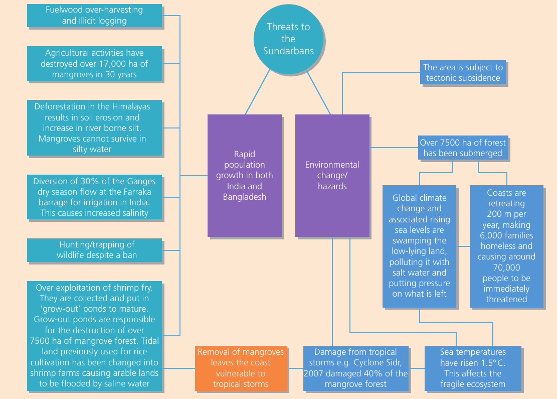
The Sundarbans faces threats from both human activities and natural environmental changes. These pressures are interconnected and often amplify one another.
Human activity threats
Rapid population growth:
Population pressure in both India and Bangladesh has led to increased exploitation of natural resources:
- Fuelwood over-harvesting and illegal logging: Local communities depend on mangrove wood for fuel and construction materials
- Agricultural expansion: Over the past 30 years, agricultural activities have destroyed approximately 17,000 hectares of mangrove forest
- Hunting and trapping of wildlife: Despite legal protections, hunting continues and has contributed to species decline
- Shrimp farming: The collection and cultivation of shrimp has been particularly damaging. Shrimp are collected and raised in grow-out ponds, which has resulted in the destruction of over 7,500 hectares of mangrove forest. Previously, tidal land used for rice cultivation has been converted into shrimp farms, causing arable lands to be flooded by saline water
Water diversion and deforestation:
- The Ganges River has been diverted at the Farakka Barrage for irrigation in India, reducing dry season flow by 30%
- This diversion has caused increased salinity in the delta
- Deforestation in the Himalayas has resulted in soil erosion, and the increased river-borne silt cannot be absorbed by mangroves in silty water
Environmental and natural hazards
Climate change impacts:
- Sea temperatures have risen by 1.5°C, affecting the fragile ecosystem
- Global climate change and associated rising sea levels are submerging low-lying land
- Rising sea levels are polluting freshwater with salt water, putting pressure on remaining habitats
Coastal retreat and displacement:
The coastline is retreating at a rate of 200 metres per year. This rapid retreat has forced 70,000 families to become homeless, and it immediately threatens an additional 70,000 people.
Tectonic subsidence:
The area is subject to tectonic subsidence (sinking), which compounds the effects of sea-level rise. Over 7,500 hectares of forest have been submerged as a result.
Tropical storms:
The region experiences frequent and devastating cyclones. Cyclone Sidr in 2007 damaged approximately 40% of the mangrove forest. When mangroves are removed, the coast becomes vulnerable to tropical storms, creating a dangerous feedback loop.
Issues and impacts arising from threats
The combined pressures on the Sundarbans have resulted in serious ecological and social consequences.
Biodiversity decline:
Threats to the ecosystem have resulted in:
- A decline in the standing volume of the two main commercial mangrove species
- Depletion of biodiversity
- Five mammal species have become locally extinct since the beginning of the twenty-first century: Javan rhinoceros, water buffalo, swamp deer, and probably hog deer
Agricultural changes:
Between 2001 and 2008, the area under agriculture in the Indian Sundarbans reduced from 2,149 km² to 1,691 km², and it continues to fall. This decline is primarily due to rising sea levels and shrinking forest area.
Human-wildlife conflict:
As rising sea levels reduce available space and forests shrink, humans and tigers increasingly compete for territory. Farmers are forced into forests to hunt for honey, fish or collect crabs. This brings them into direct contact with tigers, putting them at risk of attack. Many men have been killed by tigers, creating numerous 'tiger widows' – women who have been forced from their homes because they cannot support their families after losing their husbands.
Fishing decline:
Over-exploitation of aquatic species has severely impacted the fishing industry. In the last 15 years, coastal fishing has experienced a dramatic decline in catch-per-unit effort. Catches have fallen from 150-200 kg per haul to just 58-65 kg per haul.
Population displacement and migration:
- Cyclones alone account for approximately 45% of all deaths in the Sundarbans
- Some islands are far more vulnerable to extreme climate conditions than others
- Plans have been developed to move people from vulnerable areas to more stable zones and urban areas outside the Sundarbans
- This would significantly decrease the at-risk population and allow abandoned land to be converted into protected areas
Economic migration:
It is estimated that roughly 60% of the male workforce in the Indian Sundarbans is moving away from the region. Workers have migrated to:
- Construction and mining jobs in Mauritius
- Indian states of Kerala, Gujarat, Karnataka and Maharashtra
Many women, unable to make ends meet, have turned to work in brick kilns, which have replaced the water bodies that previously dotted the delta.
Infrastructure damage:
Cyclones have badly damaged much of the 3,500 km of river embankments constructed by the British in the 18th century. These embankments were essential for protecting low-lying areas from flooding.
Management responses and conservation efforts
Various strategies have been implemented to address the threats facing the Sundarbans, though population pressure continues to undermine many efforts.
Protected status:
The entire Sundarbans is designated as reserved forest. This protection was established under the Indian Forest Act of 1878, when both India and Bangladesh were part of the British Empire. Since independence, additional wildlife refuge areas have been created on both sides of the border.
Conservation regulations:
These sanctuaries are designed to prohibit:
- Entry of people
- Cultivation of land
- Damage or destruction of vegetation
- Hunting or capturing of wild animals
- Introduction of exotic species
- Straying of domestic animals
- Causing of fires
- Pollution of water
However, much of this protection is not working effectively as population pressure continues to grow.
International recognition:
A large part of this ecoregion has been designated as a World Heritage Site in both India and Bangladesh. This status recognises the area's exceptional ecological value and helps attract international support for conservation efforts.
Fishing management:
The Indian government has restricted the number of boats permitted to fish in Sundarbans waters. This is managed through issuing Boat Licensing Certificates – documents that authorise specific fishing activities. In Bangladesh, fishing regulations have been strengthened with:
- Increased compliance with fishery rules
- Community outreach initiatives
- Harsh penalties and boat confiscations for rule breakers
Temporary fishing camps:
Fishing camps are established every season by local people. These provide a controlled way to ensure a supply of fresh fish to local markets. Men also venture into the forest to hunt, collect honey or cut firewood.
Embankment reconstruction:
The Indian Government has initiated the Sundarbans Embankment Reconstruction Project. This project uses modern machinery to support local efforts to rebuild new and more sturdy embankments, replacing those damaged by cyclones over the years.
Key Points to Remember:
- The Sundarbans is the world's largest mangrove forest system, spanning 10,000 km² across India and Bangladesh, supporting exceptional biodiversity including the Royal Bengal tiger
- The region faces dual threats: human pressures (agricultural expansion destroying 17,000 hectares, shrimp farming destroying 7,500 hectares, overfishing) and environmental hazards (climate change, rising sea levels causing 200m annual coastal retreat, and devastating cyclones)
- Ecological impacts include declining fish catches (from 150-200 kg to 58-65 kg per haul), five mammal species becoming locally extinct, and 70,000 people displaced by coastal retreat
- Management responses include reserved forest status under the 1878 Indian Forest Act, World Heritage Site designation, fishing controls through Boat Licensing Certificates, and the Sundarbans Embankment Reconstruction Project
- Social consequences include the 'tiger widows' phenomenon and mass migration of 60% of the male workforce to find employment elsewhere, whilst cyclones account for 45% of all deaths in the region