Case Study: Helvellyn, Lake District (AQA A-Level Geography): Revision Notes
Case Study: Helvellyn, Lake District
Location and context
The Helvellyn area in the English Lake District provides an excellent example of a glaciated upland landscape. The Helvellyn Range extends approximately north-south for about 11 kilometres, with Helvellyn peak itself reaching 950 metres in elevation. The range forms a ridge of high ground exceeding 600 metres in height throughout its length.
This landscape has been shaped by repeated glaciations over the past 800,000 years. Ice sheets advanced and retreated approximately 11 times during this period, with the most recent glacial maximum occurring around 22,000 years before present (BP). These repeated ice advances profoundly transformed the pre-existing drainage system and created the distinctive glacial features visible today.
Processes shaping the landscape
Glacial erosion and deposition
During glacial periods, ice was the dominant force carving the landscape. Two main erosional processes operated:
- Abrasion - where rock fragments frozen into the base of the glacier scraped and scratched the bedrock beneath, creating smooth surfaces and grooves
- Plucking - where ice froze onto bedrock and pulled away blocks of rock as the glacier moved, steepening rock faces
These processes widened and deepened pre-existing valleys and hollows, creating distinctively U-shaped valleys and armchair-shaped corries. As glaciers retreated during warmer phases, meltwater deposited sediment across the landscape, creating various depositional features.
Understanding the difference between abrasion (scraping and scratching) and plucking (pulling away rock blocks) is essential for explaining how glaciers erode landscapes. These two processes work together to create the dramatic features we see today.
Periglacial and postglacial modification
Between glacial advances (interglacials), the landscape underwent further change through:
- Weathering processes breaking down exposed rock surfaces
- Mass movement transporting material downslope
- Fluvial action by rivers and streams
These processes continue today, alongside human activity, constantly reshaping the glacial landscape features. The current landscape therefore represents a complex assemblage of features created by glacial, periglacial, fluvio-glacial and postglacial processes operating over hundreds of thousands of years.
Landscape features
Corries and tarns
Corrie: An armchair-shaped hollow found in mountainsides, formed by glacial erosion. Also known as a cirque or cwm.
The Lake District contains over 150 corries, demonstrating the extensive glacial activity in the region. In the Helvellyn area, most corries are located on the eastern side of the range. This concentration on the east-facing slopes occurred because these locations were most conducive to snow accumulation during colder periods, as they face away from prevailing westerly winds.
Many corries are found at higher altitudes where conditions were most favourable for snow to accumulate and compact into ice. Named examples in the Helvellyn area include:
- Red Tarn
- Brown Cove
- Nethermost Cove
- Grisedale Tarn
Tarn: A mountain lake occupying the basin of a corrie, typically found at high altitudes.
These tarns fill the over-deepened hollows created by rotational ice movement within the corries. Many corries are positioned adjacent to one another, separated by narrow ridges.
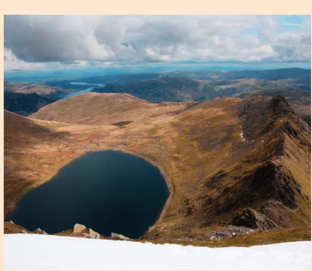
The photograph above shows Red Tarn, one of the most impressive tarns in the area, viewed from Helvellyn summit with the dramatic arête of Striding Edge visible. Notice how the tarn occupies the deepest part of the corrie basin, created by intense glacial erosion.
Arêtes
Arête: A narrow, knife-edge ridge formed between two adjacent corries as glaciers erode backwards into the mountainside from both sides.
Several prominent arêtes are found in the Helvellyn area where neighbouring corries have eroded the rock between them. Two particularly impressive examples are:
- Swirral Edge - a sharp ridge formation
- Striding Edge - one of the most famous arêtes in England, offering spectacular views but requiring careful navigation
Over time, continued erosion from either side has sharpened these ridges, creating the characteristic knife-edge profiles visible today. These features experience ongoing modification through weathering, frost shattering and mass movement on the steep scree slopes flanking them.
Ribbon lakes
Ribbon lakes: Long, narrow lakes occupying glacially over-deepened valleys, radiating outward from former centres of ice accumulation.
Major ribbon lakes in the area include Ullswater and Windermere. These lakes fill valleys that were significantly deepened by glacial erosion as ice flowed outward from accumulation zones in the mountains. The glaciers carved these valleys far deeper than rivers could have achieved, creating the characteristic elongated shape and considerable depth of ribbon lakes.
The lakes occupy sections of valleys where glacial erosion was particularly intense, often where ice flow was concentrated or valley floors were already lower. During interglacial periods, these over-deepened basins filled with meltwater to form the lakes visible today.
Glacial troughs
Valleys such as Grisedale and Glenridding display the classic U-shaped cross-section of glacial troughs. These valleys provide excellent opportunities to examine evidence of glacial erosion processes, including:
- Striations - parallel scratches on exposed rock surfaces showing the direction of ice movement
- Truncated spurs - where interlocking river spurs were sliced off by the glacier, creating steep valley sides
- Hanging valleys - tributary valleys left "hanging" above the main valley floor after over-deepening
- Roche moutonnée - streamlined bedrock features smoothed on one side and roughened on the other
Field Investigation: Identifying Glacial Trough Features
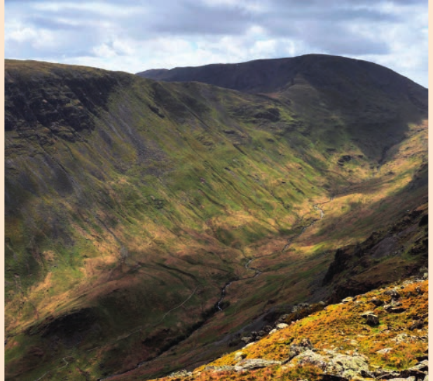
The Grisedale valley, shown above, demonstrates the characteristic U-shaped profile created by glacial erosion. When investigating glacial troughs in the field, look for:
- Valley shape: Wide, flat floor with steep, parallel sides (U-shape)
- Valley sides: Evidence of truncated spurs where the glacier cut through
- Rock surfaces: Striations showing ice flow direction
- Tributary valleys: Hanging valleys entering high up on the valley sides
Compare this to V-shaped river valleys to understand the difference glacial erosion makes to landscape form.
Depositional features
Higher sections of valleys like Grisedale contain numerous moraines - ridges of sediment deposited by glaciers. These moraines originated from various glacial phases and now exhibit evidence of subsequent weathering and erosion since their formation.
Investigating these moraines can reveal information about:
- The distribution pattern across the landscape
- The orientation relative to ice flow direction
- The scale and dimensions of features
Where glacial deposits are exposed, techniques such as till fabric analysis can be employed to investigate the characteristics of the deposited material, providing insights into how it was transported and laid down by ice.
Investigation and fieldwork opportunities
The Helvellyn area offers numerous opportunities for geographical fieldwork and investigation. Many landscape features can be studied using both field observations and secondary data sources such as Ordnance Survey maps.
Features suitable for investigation
Corries and ribbon lakes:
- Measuring and mapping the orientation to identify patterns (e.g., east-facing concentration)
- Recording the length and width dimensions of ribbon lakes
- Measuring the height of corrie headwalls
Arêtes:
- Mapping the distribution of arêtes across the area
- Identifying the relationship between neighbouring corries
- Examining weathering features and scree formation
Glacial troughs:
- Mapping the location and orientation of striations on exposed rock surfaces
- Identifying and measuring features such as valley width, truncated spurs, and hanging valleys
- Recording evidence of post-glacial weathering including frost shattering and scree slopes
Moraines:
- Mapping the distribution across valleys
- Recording orientation patterns
- Measuring the scale and dimensions of moraine ridges
- Analysing deposited material characteristics where exposures exist
Investigation methods
Field investigations can be combined with OS map analysis to build a comprehensive understanding of the glaciated landscape. Maps allow identification of feature distribution across areas that may not be easily accessible on foot, whilst fieldwork provides detailed ground-truth observations of specific features and processes.
This combination of approaches enables students to investigate the full range of glacial processes and their landscape outcomes, from erosional features in upland areas to depositional features in valley locations.
Key Points to Remember:
- The Helvellyn area was shaped by repeated glaciations over 800,000 years, with ice advancing and retreating 11 times
- Over 150 corries are found in the Lake District, concentrated on east-facing slopes where snow accumulated most readily
- Key erosional features include corries (with tarns), arêtes (such as Striding Edge), ribbon lakes (Ullswater and Windermere), and U-shaped glacial troughs (Grisedale valley)
- Depositional features like moraines provide evidence of ice extent during different glacial phases
- The area offers excellent fieldwork opportunities to investigate both erosional and depositional glacial features using field observations and OS maps
- Understanding the difference between glacial processes (abrasion and plucking) is essential for explaining landscape formation
- The current landscape represents the combined effects of glacial, periglacial, and postglacial processes operating over hundreds of thousands of years