Depositional Landforms (AQA A-Level Geography): Revision Notes
Depositional landforms
Introduction to glacial deposition
When glaciers melt, they deposit enormous amounts of rock, sand, clay and other sediment that they have carried during their movement. These deposits create distinctive landscape features that help geographers understand past ice coverage and glacier behaviour.
There are two main types of glacial deposits that you need to understand:
- Lodgement till - material deposited directly by the moving glacier itself
- Ablation till - material deposited when ice melts at the glacier snout
Each type creates different landforms in the landscape.
Lodgement till
Lodgement till is material deposited beneath a moving glacier. As the ice advances, it plasters sediment directly onto the bedrock below.
Drumlins
The most distinctive feature formed from lodgement till is the drumlin. This streamlined hill is created as the glacier moulds and shapes material it has already deposited.
Ablation till
Ablation till is material released when ice melts at the glacier snout (front). This creates several important depositional features.
The main landforms created by ablation till include:
- Terminal (end) moraines - ridges marking the furthest extent of the ice
- Push moraines - ridges created when glaciers advance and push up existing deposits
- Recessional moraines - ridges marking temporary pauses during glacier retreat
Drumlins in detail
The word 'drumlin' comes from the Gaelic term 'druim', meaning a rounded hill. These landforms are sometimes described as looking like 'whalebacks' due to their distinctive streamlined shape.
Key characteristics of drumlins
- Shape: Smooth, oval hills resembling half an egg
- Size: Can reach up to 1.5 km in length, though most are considerably smaller
- Height: Typically 50-60 metres high
- Orientation: Elongated in the direction of ice movement
- Profile: Steeper 'blunt' end facing upstream, gentler 'tapered' end pointing downstream
- Composition: Formed from unsorted till with little internal structure
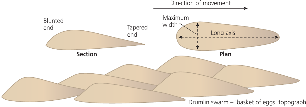
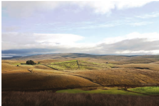
Drumlin distribution
Drumlins rarely occur individually. Instead, they form in clusters known as swarms, creating what is sometimes called "basket of eggs" topography due to their distinctive appearance from above.
Common locations for drumlins include:
- Lowland plains, particularly in central Scotland
- The Ribble Valley, with notable examples at Hellifield
- Lower sections of glacial valleys
- Areas behind terminal moraines
Theories of drumlin formation
There has been considerable debate among geographers about how drumlins form. Three main theories have been proposed:
Theory 1: Ice moulding The glacier shapes pre-existing glacial deposits (ground moraine) that were left during an earlier period of glaciation. The moving ice streamlines these materials into the characteristic drumlin form.
Theory 2: Obstacle moulding The glacier deposits till around an obstruction in the ice or on the valley floor, such as a protruding rock or mass of frozen till. As ice continues moving over this nucleus, it moulds the material into the drumlin shape.
Theory 3: Ice overloading (most widely accepted) The glacier becomes overloaded with sediment and debris, which reduces its ability to carry material. Deposition occurs at the base of the ice, and this material is then shaped by continued glacier movement.
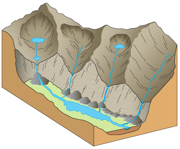
Erratics
Erratics are large blocks of rock that have been transported by a glacier and deposited in an area with completely different underlying geology.
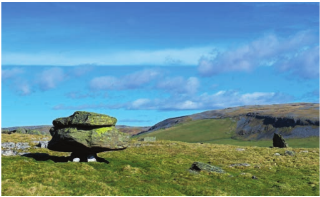
These distinctive boulders can be identified because their rock type does not match the local bedrock. By studying erratics, geographers can track the direction and extent of past glacier movement. For example, granite erratics found on limestone uplands indicate that ice has transported rock from a granite source area many kilometres away.
Moraines
Moraines are ridges or series of mounds consisting mainly of unsorted glacial material. They run across glacial valleys and mark significant points in a glacier's history.
Terminal moraines
Terminal moraines are ridges of deposited material that stretch across a glacial valley, marking the furthest point reached by the glacier snout.
Key features of terminal moraines:
- Form a ridge or series of mounds across the valley
- Elongated at right angles to the direction of ice advance
- Often steep-sided, particularly on the ice-contact face
- Can reach heights of 50-60 metres
- Frequently crescent-shaped or gently curved
- Sometimes moulded into the characteristic form of the glacier snout
Formation Process: Terminal Moraines
Terminal moraines develop when a glacier snout remains stationary for a period of time. Although the ice front is not advancing, ice continues flowing from the accumulation zone upstream.
Step 1: Continuous ice flow The glacier acts like a conveyor belt, continuously bringing material forward from upstream.
Step 2: Deposition at the snout Material is deposited at the snout as ice melts and releases its load.
Step 3: Ridge formation This creates a substantial ridge of unsorted material ranging from fine clay particles to large boulders.
Recessional moraines
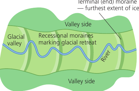
Recessional moraines are ridges formed along a glacial valley that mark positions where the retreating glacier paused temporarily.
As climate conditions change and glaciers begin to retreat, they do not simply melt continuously. Instead, the retreat is interrupted by periods when the ice front stabilises. During these pauses, material accumulates in the same way as terminal moraines, but these ridges form behind the original terminal moraine.
A series of recessional moraines along a valley provides evidence of the pattern and rate of glacier retreat. Each ridge represents a temporary stillstand during the overall retreat phase.
Push moraines
When climate cools and a glacier begins advancing again, it may encounter material that was deposited during an earlier period. The advancing ice pushes this sediment forwards and upwards, creating a push moraine.
These features can be identified by examining the orientation of individual rocks within them. If stones show evidence of being tilted upwards from their original horizontal position, this indicates they have been pushed by advancing ice.
Till plains
Till plains are extensive areas of relatively flat terrain created by widespread deposition from an ice sheet.
These features are typically found:
- Behind terminal moraines
- Towards the margins of former ice sheets
- In low-lying areas
Characteristics of till plains
Till plains cover wide areas of generally flat relief, but the underlying bedrock may be quite uneven. This unevenness is concealed by thick layers of glacial deposits including till, sand, and gravel. The variable thickness of these deposits depends on depressions in the underlying surface.
The poor drainage of till plains means they often contain:
- Bogs and wetland areas
- Lakes and ponds
- Slow-moving, meandering streams
Extensive till plains exist south of the Great Lakes in North America. These mark the margins of the Laurentide ice sheets that covered the region during glacial periods.
Characteristic glaciated landscapes
Regions that have experienced repeated glaciation during the Quaternary Ice Age, such as the European Alps, display landscapes dominated by glacial features. Countries including Austria, Italy, France and Switzerland contain numerous valleys that showcase the landforms discussed in this topic.
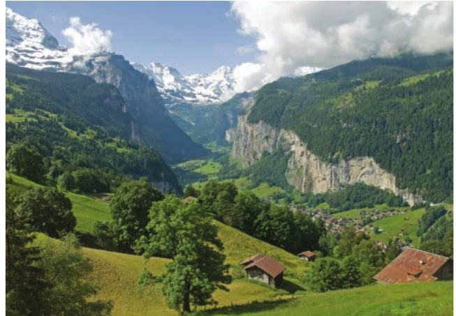
A excellent example is the Lauterbrunnen Valley, located close to Bern in Switzerland. This valley demonstrates many characteristic features of a glaciated landscape, including steep valley sides, a flat valley floor, and multiple depositional features.
The Alps exhibit many valleys with similar characteristics:
- Deep, U-shaped valley profiles
- Steep valley walls
- Flat valley floors with meandering rivers
- Terminal and recessional moraines
- Evidence of multiple glaciation events
- Integration of erosional and depositional features
These landscapes provide valuable evidence for understanding glacier behaviour and the significant role ice has played in shaping our physical geography.
Key Points to Remember:
-
Two types of glacial deposits: Lodgement till (from moving ice) creates drumlins, while ablation till (from melting ice) forms moraines
-
Drumlins are streamlined hills: Blunt upstream end, tapered downstream end, found in swarms creating "basket of eggs" topography on lowland plains
-
Moraines mark glacier positions: Terminal moraines show furthest extent, recessional moraines mark retreat pauses, push moraines indicate re-advance
-
Erratics are out of place: Large rocks deposited far from their source, with geology different from surrounding bedrock
-
Till plains are extensive and flat: Poorly drained areas created by ice sheets, containing unsorted material from clay to boulders