Case Study: Mount Mayon, Philippines (2018) (AQA A-Level Geography): Revision Notes
Case Study: Mount Mayon, Philippines (2018)
Introduction to Mount Mayon
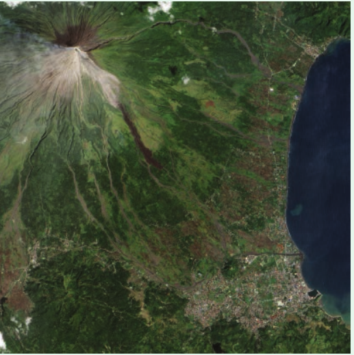
Mount Mayon is a striking example of an active composite volcano in the Philippines. Standing at 2,462 metres above sea level, it holds the distinction of being the country's most active volcano, with documented eruptions dating back over 400 years to 1616. The volcano is situated within a 250 km² national park in Albay province and is surrounded by the city of Legaspi and eight smaller towns.
The volcano is renowned for its near-perfect symmetrical conical shape, which makes it a popular tourist destination. However, this beauty masks significant volcanic hazards that threaten the surrounding population.
Geological setting
Mount Mayon's volcanic activity is directly linked to its tectonic position. The volcano formed as a result of the subduction of the Philippine Sea Plate beneath the Sunda Plate, placing it within the Pacific Ring of Fire. This tectonic setting creates the conditions for regular volcanic activity, with magma generated as the oceanic plate descends into the mantle.
PHIVOLCS (Philippine Institute of Volcanology and Seismology) is the government agency responsible for monitoring volcanic activity, earthquakes, and tsunamis across the Philippines. The organization continuously tracks Mount Mayon's activity to provide early warnings to at-risk communities.
Risk and vulnerability
The population living near Mount Mayon faces multiple volcanic hazards. Understanding these risks is crucial for effective disaster management.
Population exposure
Large ash emissions from Mount Mayon typically settle within a few kilometres of the volcano, directly affecting the nearby city of Legaspi. As the capital of Albay province, Legaspi has a population of almost 200,000 people and serves as a major regional centre for:
- Tourism and education
- Healthcare and social services
- Commerce and transportation
This concentration of population and infrastructure creates significant vulnerability to volcanic hazards.
Types of hazards
Mount Mayon presents several distinct volcanic hazards:
Ash emissions create immediate dangers as fine rock particles settle on roofs, causing buildings to collapse under the weight. In the short term, ash destroys local agriculture by covering crops and contaminating soil. However, over longer periods, volcanic ash actually enriches the soil with minerals, eventually improving agricultural productivity.
Pyroclastic flows (also known as nuées ardentes) are particularly dangerous. These fast-moving currents of hot gas and volcanic material are funneled down the gullies on the volcano's flanks, destroying everything in their path.
Lahars pose a severe threat due to the region's high rainfall. The area receives approximately 3,432 mm of rainfall annually, with January and February being the wettest months. When this heavy rain mixes with loose volcanic ash in the gullies, it creates devastating mudflows that can travel far from the volcano, destroying infrastructure and agricultural land.
Lava flows from the central crater travel down the mountain's flanks, destroying any local agriculture in their path. These flows are typically associated with longer-term andesitic eruptions following initial basaltic activity.
The 2018 eruption: timeline of events
Historical data shows that Mount Mayon's eruption cycles typically begin with ash emissions and basaltic eruptions, followed by more sustained andesitic lava flows from the central crater. The 2018 eruption followed this pattern, with pyroclastic flows and mudflows sweeping down approximately 40 ravines radiating from the summit.
Mount Mayon had erupted regularly throughout the first 20 years of this century, but the 2018 eruption proved to be the most significant event. The following timeline documents how the eruption developed and how authorities responded.
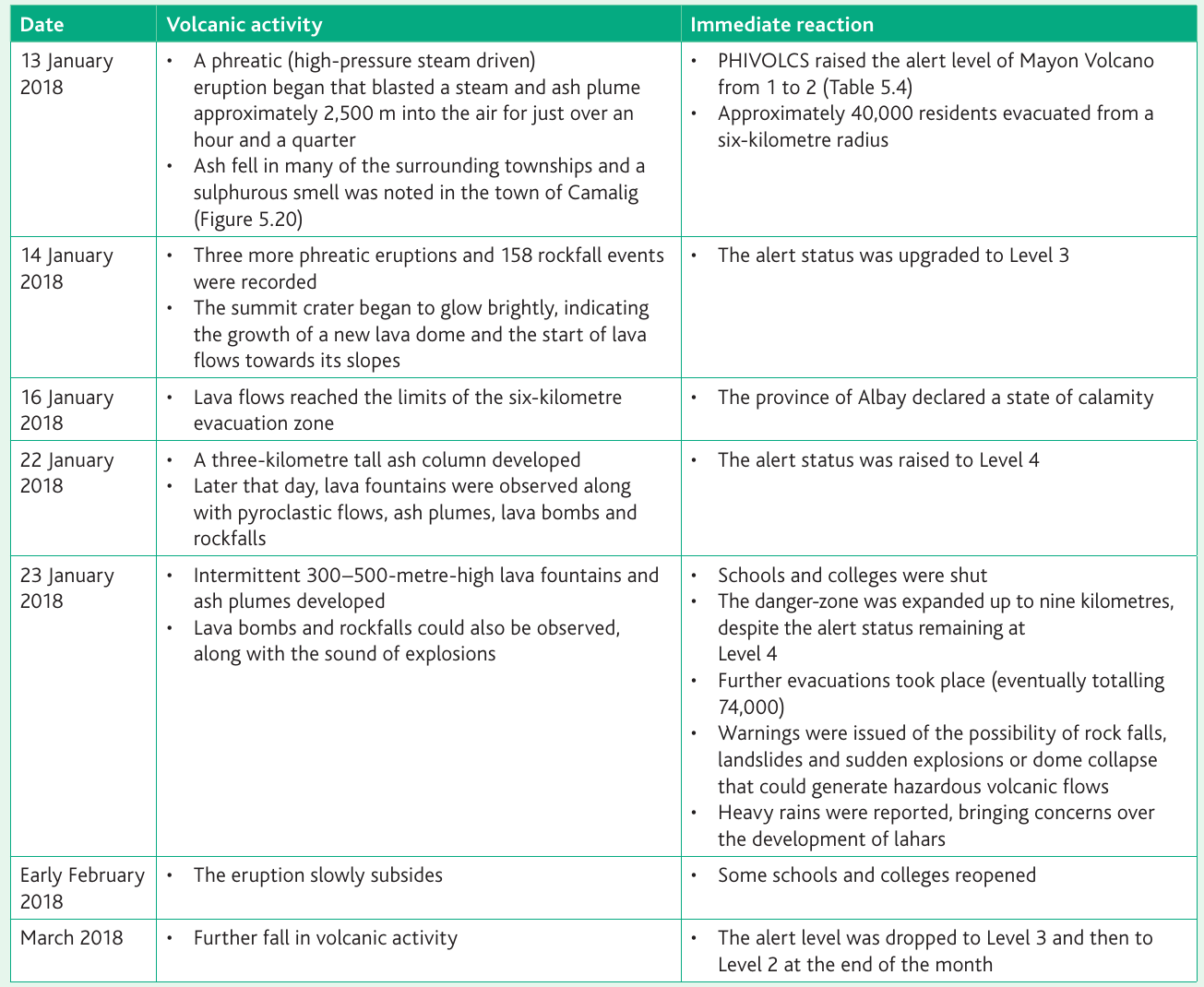
Initial activity (13-14 January 2018)
The eruption began on 13 January 2018 with a phreatic (steam-driven) eruption. This explosive event blasted a plume of steam and ash approximately 2,500 metres into the atmosphere, lasting just over an hour. Ash fell across many surrounding townships, and residents in the town of Camalig reported a strong sulphurous smell.
PHIVOLCS immediately responded by raising the alert level from 1 to 2, recognizing the increased volcanic unrest. Authorities ordered the evacuation of approximately 40,000 residents from within a six-kilometre radius of the volcano.
The following day (14 January), activity intensified. Three additional phreatic eruptions occurred, accompanied by 158 rockfall events. Significantly, the summit crater began to glow brightly at night, indicating that a new lava dome was forming and lava flows had begun moving down the volcano's slopes. This escalation prompted PHIVOLCS to upgrade the alert status to Level 3.
Escalation phase (16-23 January 2018)
By 16 January, lava flows had reached the edge of the six-kilometre evacuation zone, demonstrating that the eruption was continuing to intensify. The province of Albay responded by declaring a state of calamity, unlocking additional emergency resources.
The eruption reached its peak on 22 January when a massive ash column developed, rising three kilometres into the sky. Later that day, dramatic lava fountains were observed, accompanied by pyroclastic flows, explosive ash plumes, lava bombs, and continuous rockfalls. The severity of these conditions led PHIVOLCS to raise the alert status to Level 4—indicating that a hazardous eruption was imminent.
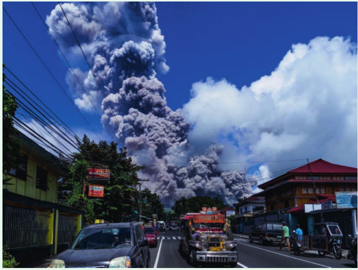
The most intense phase occurred on 23 January, when intermittent lava fountains reached heights of 300-500 metres, accompanied by ash plumes. Lava bombs and rockfalls continued, with the sounds of explosions clearly audible to nearby residents.
Authorities responded decisively to this escalation:
- All schools and colleges were closed
- The danger zone was expanded from six to nine kilometres, despite the alert level remaining at 4
- Further evacuations were ordered, eventually bringing the total number of evacuees to 74,000 people
- Warnings were issued about multiple hazards: rock falls, landslides, sudden explosions, potential dome collapse
- Heavy rains were reported in the area, raising serious concerns about the development of lahars
De-escalation (February-March 2018)
By early February, the eruption began to slowly subside. This reduction in activity allowed some schools and colleges to reopen, though authorities remained vigilant.
In March 2018, volcanic activity continued to decline. PHIVOLCS responded by lowering the alert level first to Level 3, and then to Level 2 by the end of the month, signaling that the immediate crisis had passed.
Understanding the PHIVOLCS alert system
The alert level system used by PHIVOLCS provides a clear framework for understanding volcanic risk and coordinating emergency responses. The system comprises six levels (0-5), each with specific criteria and implications.
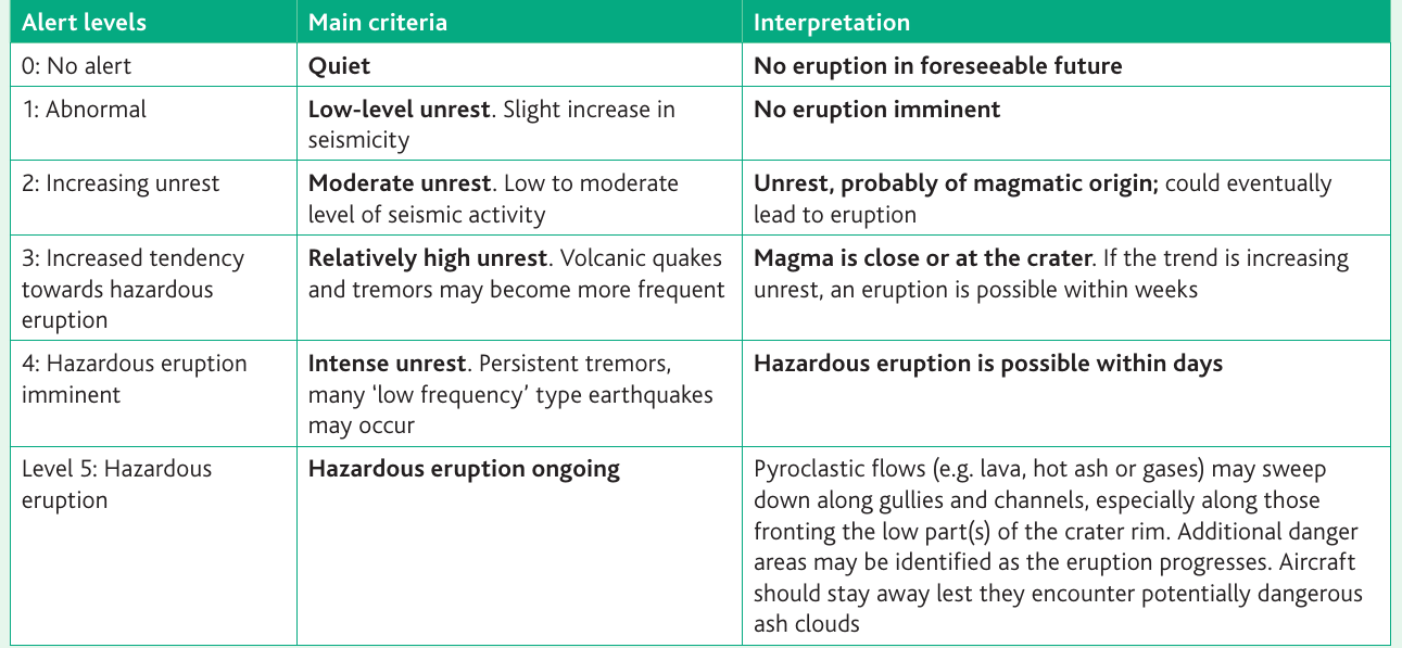
Level 0 (No alert) indicates a quiet volcano with no eruption expected in the foreseeable future. The volcano shows no unusual seismic activity.
Level 1 (Abnormal) signifies low-level unrest with a slight increase in seismicity. However, no eruption is considered imminent at this stage.
Level 2 (Increasing unrest) represents moderate unrest with low to moderate levels of seismic activity. This suggests that the unrest is probably of magmatic origin and could eventually lead to an eruption, though the timeframe remains uncertain.
Level 3 (Increased tendency towards hazardous eruption) indicates relatively high unrest, with volcanic earthquakes and tremors becoming more frequent. At this level, magma is considered close to or at the crater. If the trend continues to increase, an eruption is possible within weeks.
Level 4 (Hazardous eruption imminent) signals intense unrest with persistent tremors and many low-frequency earthquakes. A hazardous eruption is considered possible within days. This is the level reached during the 2018 eruption.
Level 5 (Hazardous eruption ongoing) means that a hazardous eruption is actively occurring. Pyroclastic flows may sweep down gullies and channels, particularly along those facing the lower parts of the crater rim. Additional danger areas may be identified as the eruption progresses, and aircraft are advised to avoid the area due to potentially dangerous ash clouds.
Impacts of the 2018 eruption
The 2018 eruption of Mount Mayon had significant social and economic consequences, though the human cost was remarkably low.
Human impacts
Remarkably, nobody was killed during the eruption. This outcome stands as a testament to the well-organized emergency procedures that had been established in the Philippines. The success of the monitoring and evacuation systems prevented loss of life despite the eruption reaching alert Level 4.
By 5 February 2018, a total of 86,052 people had been affected by the eruption. Of these, 64,895 individuals stayed in 58 designated evacuation centres established by authorities. The evacuation centres provided temporary shelter, food, and medical care for displaced families.
Economic impacts
The agricultural sector suffered significant damage. A total of $3.4 million worth of crops were destroyed, affecting more than 10,000 farmers. The main crops impacted were rice, corn, and abaca (a plant used for fiber production). This damage represented not just an immediate economic loss but also threatened food security and livelihoods for thousands of families.
Infrastructure impacts
Transportation networks experienced considerable disruption. Some roads became impassable due to landslides and accumulated ash falls. The ash in the atmosphere also forced the cancellation of some flights in and out of Legaspi airport, affecting both residents and tourism.
Responses to the eruption
The response to the Mount Mayon eruption involved coordinated efforts at local, national, and international levels.
Local and national response
The Filipino government demonstrated strong commitment to supporting affected communities. It allocated $1 million for a "Cash for Work" programme, which provided employment opportunities for evacuees while also supporting recovery efforts. Additionally, the government supplied hygiene packages to 50,000 families for ten days and provided food packs sufficient for 100 days to those in evacuation centres.
The military played a crucial role in emergency management. Army units were deployed to enforce the evacuation orders and to maintain order if any civil disturbance occurred. This helped ensure that evacuation zones were respected and that people did not return to dangerous areas prematurely.
The Philippine Red Cross established first-aid stations near evacuation centres and set up welfare desks to provide psychosocial support to affected individuals. This support was essential for helping people cope with the trauma and stress of displacement.
The National Council of Churches in the Philippines contributed to relief efforts by providing immediate assistance to 3,446 families, demonstrating the important role of faith-based organizations in disaster response.
International response
Following the declaration of a Level 3 alert for the volcano, international governments took action to protect their citizens. The United States government advised its nationals against travelling to the Mayon area, and the United Kingdom similarly discouraged British nationals from visiting the volcano.
Beyond travel advisories, the United States government provided substantial practical support. Through the United States Agency for International Development (USAID), it committed over $100,000 to the relief effort. This funding was used to:
- Distribute vouchers enabling families to purchase essential items
- Provide hygiene kits to help reduce illness in evacuation centres
- Construct latrines and bathing cubicles to improve sanitation
- Build handwashing stations to promote hygiene
- Develop and distribute educational materials about safe water and hygiene practices
These infrastructure improvements were particularly important for preventing disease outbreaks in crowded evacuation centres.
Evaluation and key observations
The 2018 eruption of Mount Mayon provides valuable lessons about volcanic hazard management. The most striking success was the prevention of any deaths despite the eruption reaching alert Level 4. This achievement demonstrates the effectiveness of PHIVOLCS monitoring systems and the established evacuation protocols.
However, volcanic activity on Mayon has continued, with further episodes occurring in 2020. This ongoing activity reminds us that volcanic hazards in this region are persistent and require sustained vigilance.
An interesting comparison can be made with a 2013 eruption of Mount Mayon. In that earlier event, five people were killed despite the eruption only reaching alert Level 2. The contrast with 2018—when zero people died at alert Level 4—suggests that improvements in emergency management and public awareness have made communities significantly more resilient to volcanic hazards.
Remember!
Key Points to Remember:
-
Mount Mayon is the Philippines' most active volcano, standing at 2,462 metres and formed by subduction processes in the Pacific Ring of Fire. It threatens nearly 200,000 people in Legaspi and surrounding areas with ash, pyroclastic flows, lahars, and lava.
-
The 2018 eruption escalated rapidly from a phreatic eruption on 13 January to alert Level 4 by 22 January, featuring lava fountains up to 500 metres high, pyroclastic flows, and a 3-kilometre ash column before subsiding in February.
-
PHIVOLCS uses a six-level alert system (0-5) based on seismic activity, providing graduated warnings from "quiet" to "hazardous eruption ongoing". The system enables timely evacuations and emergency responses.
-
Effective monitoring and evacuation prevented deaths, with 74,000 people successfully evacuated from expanding danger zones (6-9 km). By contrast, the 2013 eruption killed five people despite only reaching Level 2, highlighting improved emergency management.
-
Impacts were primarily economic and social: $3.4 million in agricultural damage affected 10,000+ farmers, 86,052 people were impacted, and infrastructure was disrupted. International aid (over $100,000 from USAID) supplemented government support through Cash for Work programmes, hygiene packages, and improved sanitation facilities in evacuation centres.